Colne Valley Western Slopes: maximising habitat creation within a large infrastructure project
The Colne Valley Western Slopes (CVWS) is one of the largest and most significant environmental projects on the High Speed Two (HS2) Phase One route and represents a synthesis of innovative landscape and ecological design alongside 21st century engineering excellence.
The CVWS represents a unique opportunity for large scale environmental enhancement with a focus on nature recovery, addressing complex climate change issues, and securing a meaningful project legacy.
The paper expands upon three key tenets of the project: 1) Increasing biodiversity by creating a mosaic of high value habitats from arable land; 2) Building in resilience and adaptability to secure sustainable outcomes and minimising our carbon footprint; and 3) Creating distinctive and accessible green spaces which contribute to health and well-being.
The paper describes the innovative design and construction solutions that have been developed which can be adopted and replicated across other large scale infrastructure projects bringing cost savings, a reduction in carbon impacts, and a focus on nature recovery. This includes the sustainable reuse of construction materials to create soil profiles; maximising carbon sequestration through well-planned soil and habitat creation design; and adherence to rewilding principles to guide landscape establishment, natural regeneration, and sustainable long-term management.
The paper will also describe how a collaborative design approach underpinned by a design vision assurance process has helped to secure integrated, multi-functional and efficient solutions.

Introduction
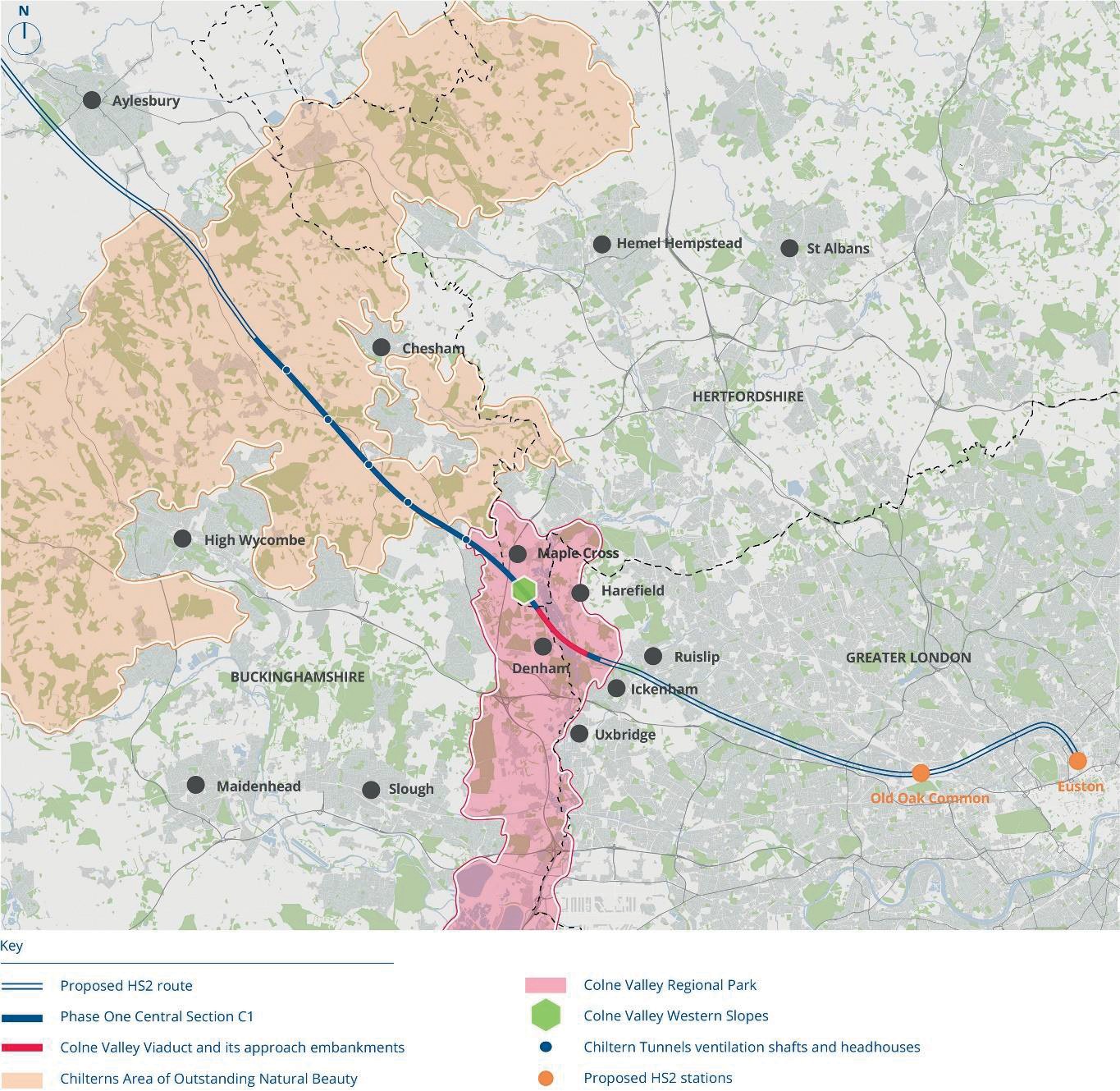
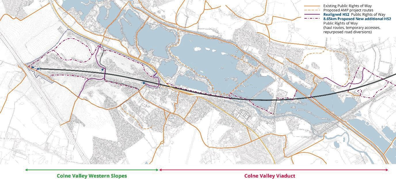
This paper presents consented design work for the Colne Valley Western Slopes (CVWS) project part of the Main Works Civils Contract (MWCC) for the central section of High Speed Two (HS2) Phase One which includes the Colne Valley Viaduct (CVV) and Chiltern Tunnel (Figure 1), being delivered by the ALIGN Integrated Project Team.
The CVWS is located between the Chiltern Tunnel and the CVV and includes the following railway assets: Chiltern Tunnel South Portal; West Hyde Embankment; Tilehouse Lane Cutting; Tilehouse Lane Overbridge; Shire Lane Culvert; and the CVV North Embankment, as well as the central construction hub for Lot C1.
The 140-hectare site extends across a gently sloping chalk escarpment within the Colne Valley, west of London, an area previously used for arable farming and mineral extraction. At the hybrid Bill stage, the CVWS was identified in the Environmental Statement (ES) [1] as an area with the potential for biodiversity and landscape led mitigation.
This paper focusses on interrelated components of the landscape and ecological design rather than that of the built assets of the railway.
The Colne Valley Western Slopes project was approved under Schedule 17 of the HS2 Act by Three Rivers District Council, Hertfordshire County Council and Buckinghamshire Council in June 2021.
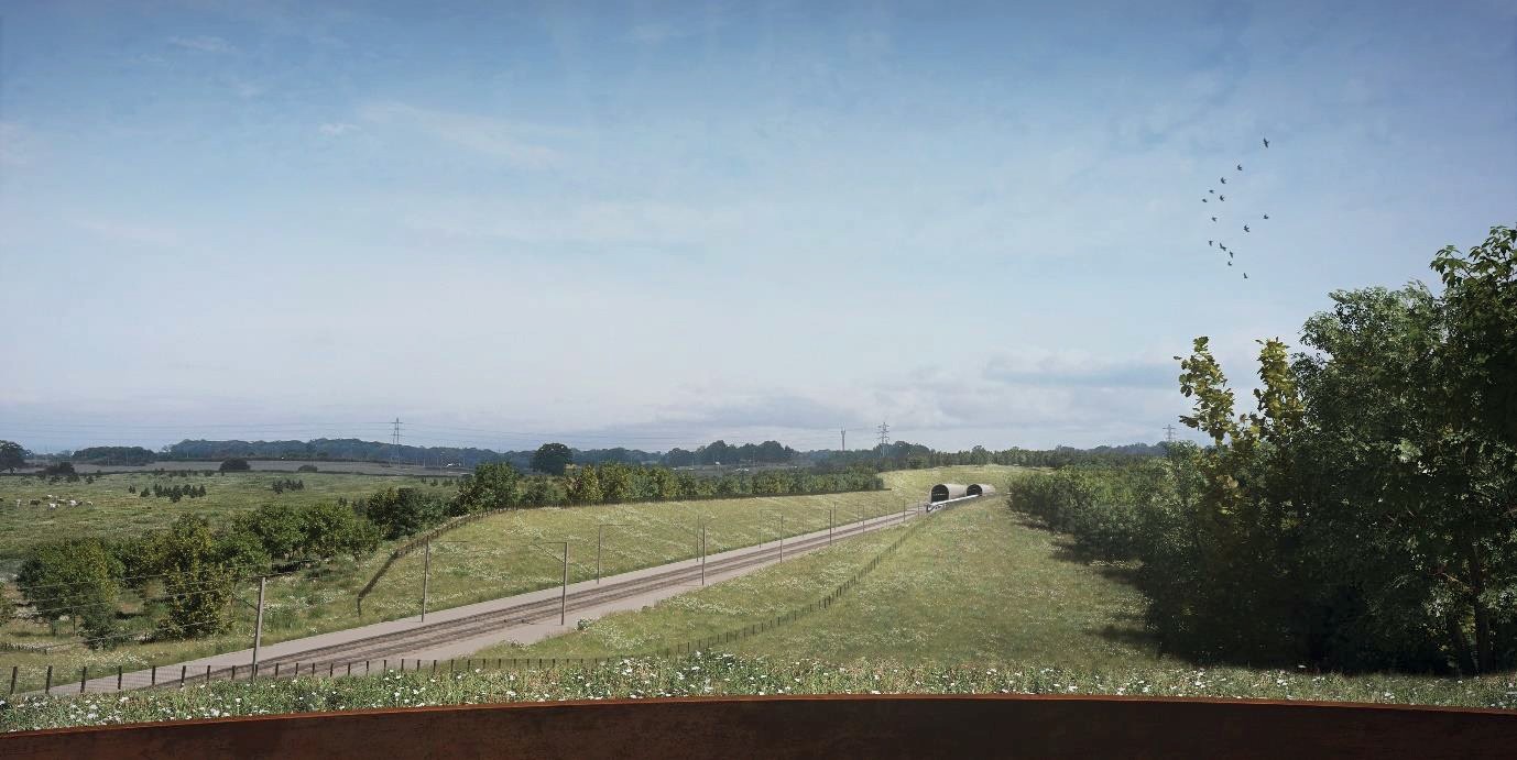
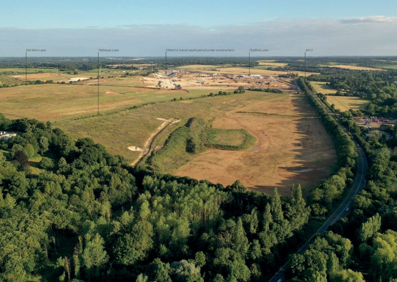
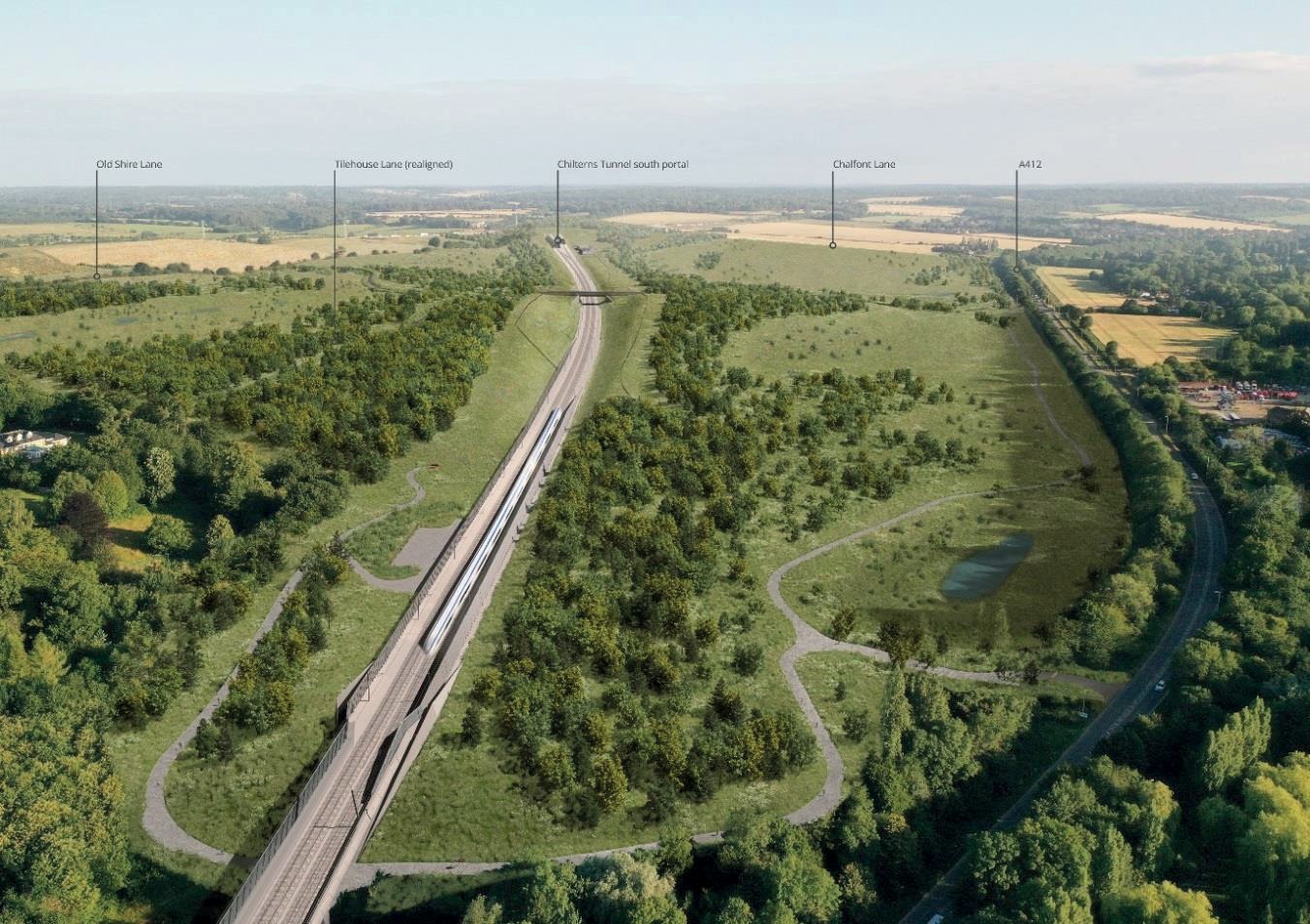
Figures 2 – 4 show key visualisations and a construction phase image of the CVWS.
Opportunities and objectives
The Colne Valley Western Slopes habitat creation project is one of the largest opportunities along the HS2 Phase One route for large scale and transformational environmental enhancement. This opportunity was recognised early in the design process and is underpinned by the ambition to create a landscape centred upon the following key objectives:
- To create a diverse, complex and rich mosaic of semi-natural habitats capable of achieving the highest biodiversity value possible.
- To balance the needs of people and the natural environment, whilst ensuring that the railway can be safely operated, and environmental impacts fully mitigated
- To integrate and connect the site to its surroundings with opportunities for active travel and access to nature; and
- To design an enduring and resilient landscape which makes best use of available resources, helps to mitigate for and adapt to climate change, and which will be managed sustainably over the long-term.
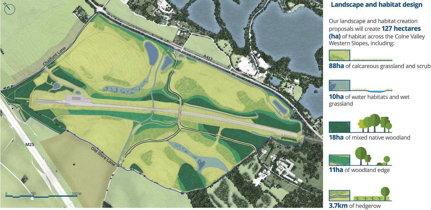
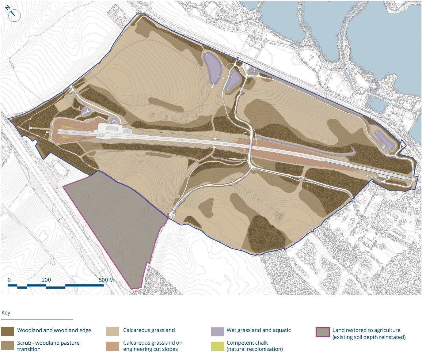
The CVWS masterplan (Figure 5) draws together the component parts of the landscape and ecological design including 127 ha of high value habitat as well as earthworks, buildings and structures, and ancillary infrastructure such as drainage and highways. For each element, the design solution addresses technical challenges; responds to commitments and obligations set by the Act including mitigation of effects; and incorporates HS2’s design and operational standards.
Design process
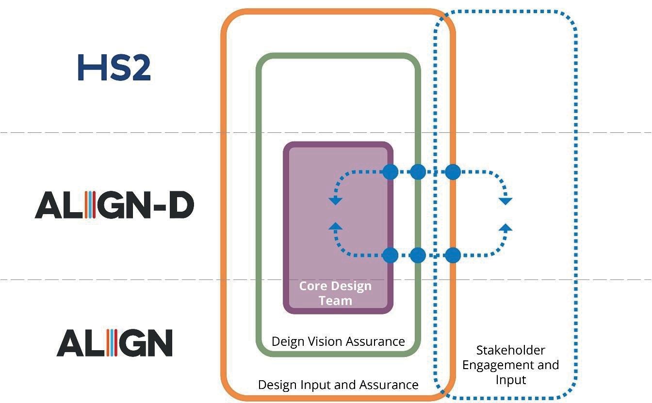
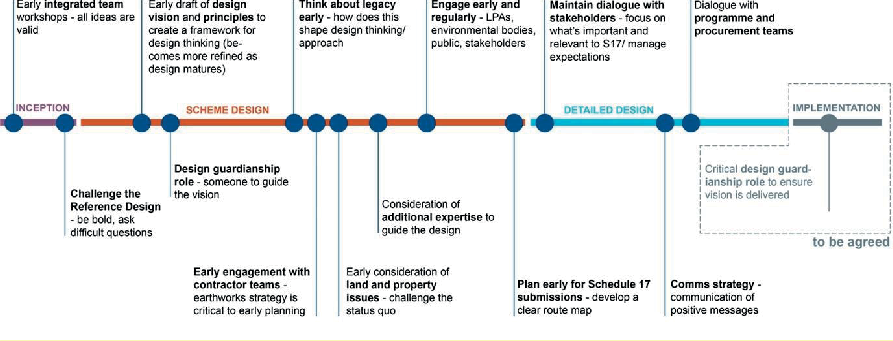
The design has been delivered through an Integrated Project Team (IPT) comprising Align, Align-D and HS2 (see Figure 6). The outcome, in design terms, owes much to a collaborative and holistic approach drawing on expertise from a multi-disciplinary team, with key outputs from ecology, landscape, soils, geotechnical, drainage, hydrology and carbon, and working closely with a variety of stakeholders, including nature conservation bodies and research organisations. Figure 7 illustrates some key lessons learned on a design timeline for the project.
Earthworks design
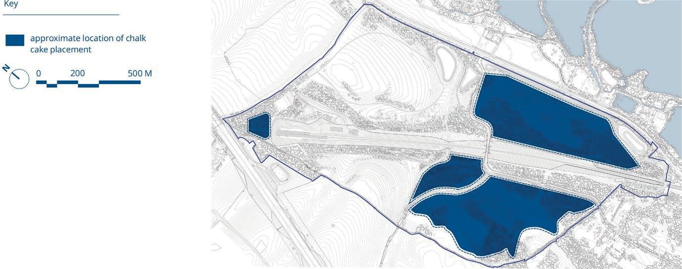
The construction of the 16 km twin-bored tunnels beneath the Chiltern Hills will generate 2.6 million m³ of processed chalk slurry fill material. This will be placed in layers and capped with site-won soils to create the landform.
The ground profiles are achieved by placing most material arising from the tunnel excavation on land within the southern half of the site, with relatively small volumes placed above the south portal area (see Figure 8). This material is referred to as ‘chalk cake’, which comprises artificial blocks of de-structured chalk silt, created by reconstituting the chalk slurry arisings. The placement areas are separate from compounds and contractor work areas and can therefore accommodate the greatest quantity of treated chalk as it is excavated without the need to store prior to placement. The land parcels within the northern half will be re-instated when the construction platforms are dismantled.
A key objective is to retain tunnel arisings on site, requiring a complex and multi-faceted earthworks design and construction methods strategy to secure a contextually appropriate solution which delivers multiple benefits. At the Hybrid Bill stage the earthworks design included a partial infilling of the chalk valleys using the tunnel arisings. This was challenged at scheme design and a more sustainable solution developed. This includes preserving the morphology of the ridges and valleys; maintaining natural hydrological and hydrogeological processes; creating suitable topography for public access; and providing complexity in slope profiles and aspect to support diverse flora and fauna.
Preserving natural drainage patterns
The existing shallow ridges and valleys are important flow paths for surface water. Several tributary valleys coalesce into a single ‘outfall’ valley in the centre of the site which connects to land within the River Colne flood plain. The developed earthworks design retains and replicates the existing ridge and valley typology to create natural conduits for surface water and groundwater. Additional shallow valleys have been formed in the landscape that are connected to wetland areas and drainage basins to achieve an integrated and multi-faceted drainage solution (Figure 9).
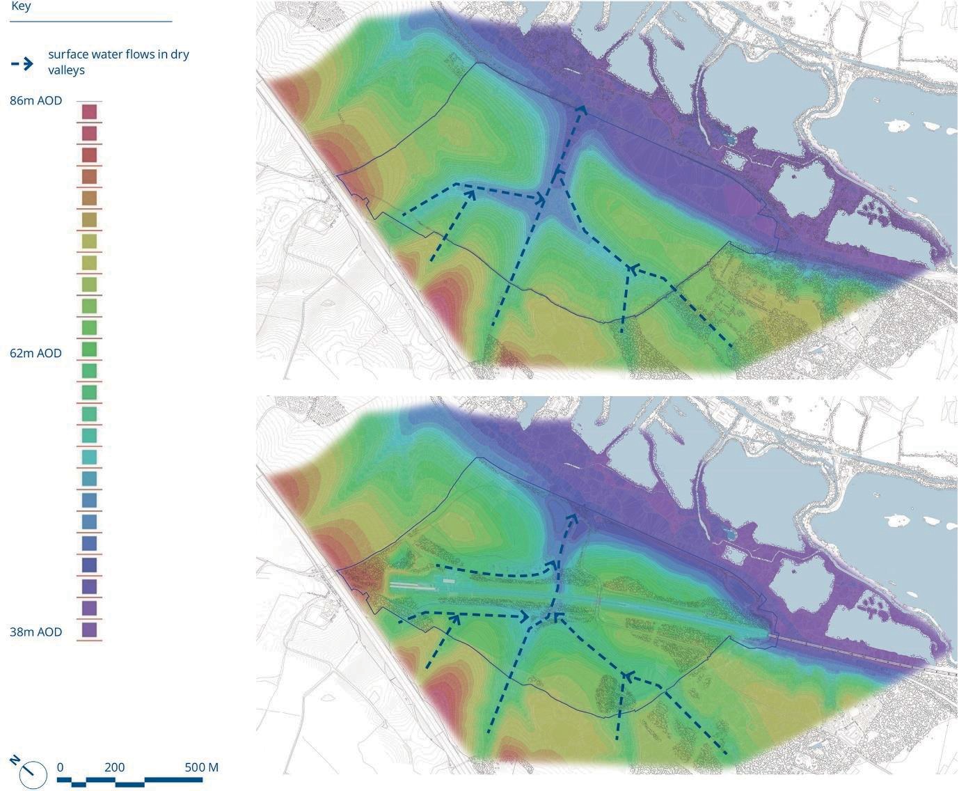
The manipulation of earthworks to achieve an efficient hydrological solution has reduced the reliance on built drainage structures. By example, the main culvert under the railway has been shortened from 630 m at early concept stage to 28 m in the developed design, providing a carbon saving of over 50 % or 482 tCO2e for this structure alone.
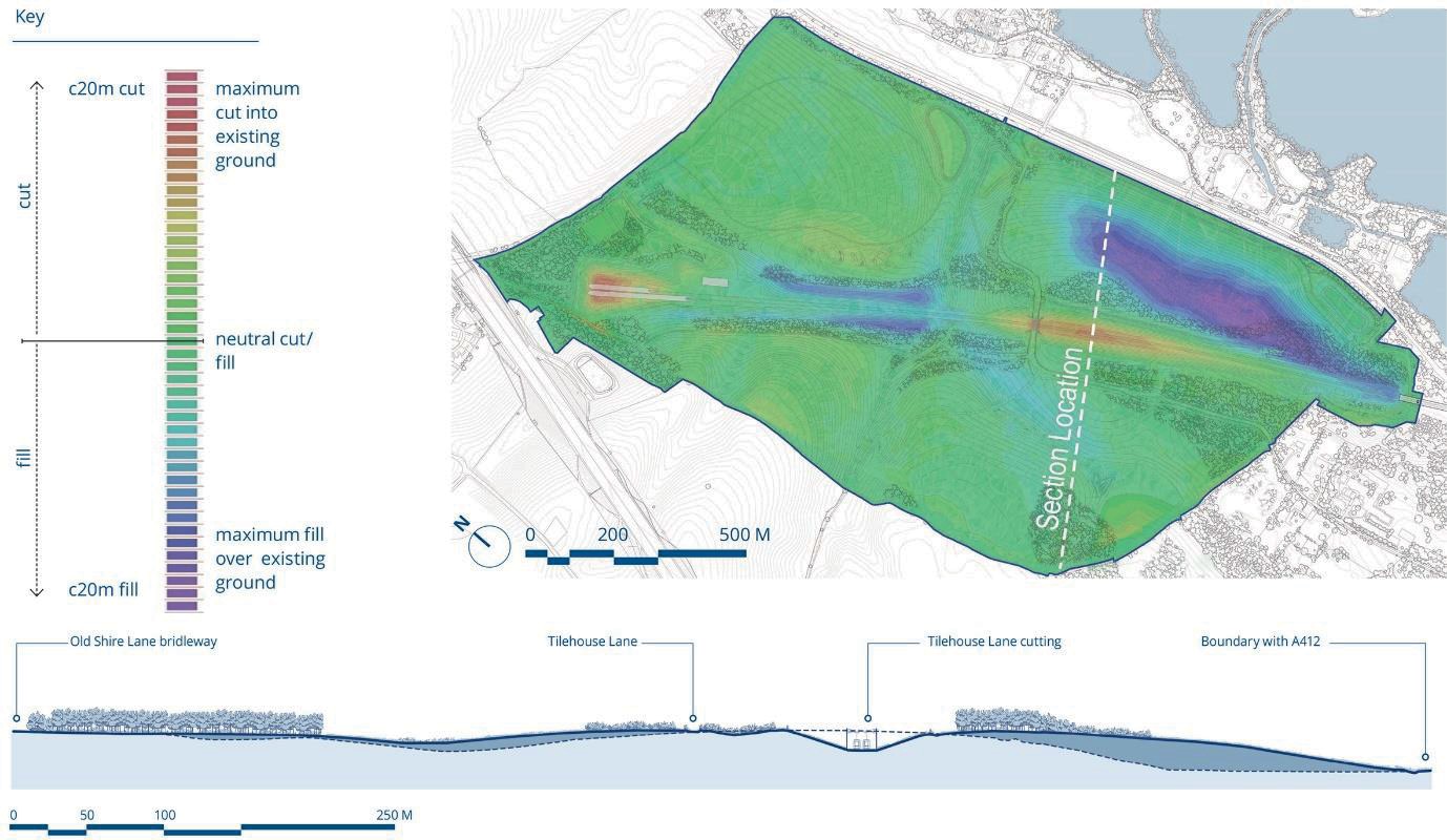
Integrated landform
The distribution of fill has been carefully considered to avoid over steepening of slopes; creating excessively engineered profiles; or impacting the visual amenity of the closest receptors. Analysis and option testing has been underpinned by ground investigation surveys and detailed construction programming.
Figure 10 shows changes in topology from earthworks placement. In addition to tunnel arisings, site-won material from the excavated cuttings will be reused to create other notable landforms including the CVV North Embankment and the false cutting at the West Hyde Embankment.
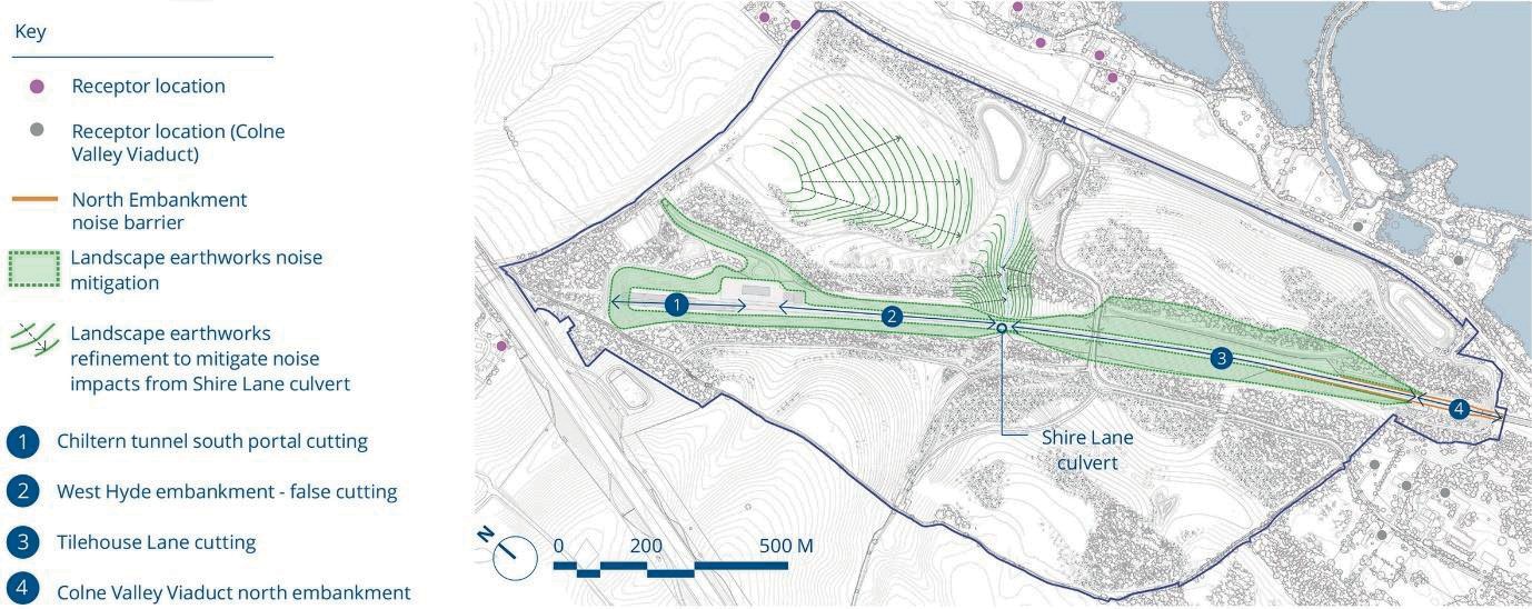
Noise mitigation
The earthworks design has sought to mitigate noise from the trains as they pass through the open route. The earthworks design and acoustic assessment has been a collaborative and iterative process between the landscape and noise teams, to achieve the best combination of acoustic screening performance without affecting the landscape and visual context and operational demands on the land.
Overall, the adapted earthworks design has achieved the acoustic performance levels assessed by the ES without the need for additional noise barriers. The earthworks which provide a noise attenuation function are illustrated in Figure 11.
Soil profiles
Soils contain a high proportion of terrestrial biodiversity and are critical to ecosystem functions. The physical and chemical characteristics of the soils lead to the development of diverse communities of soil organisms interacting within complex food webs that are intimately linked to plants and above ground fauna.
The habitat creation designs have been led by the soils and substrate design, considering the inherent properties of the soils on site, and identifying modifications to soil profiles to provide the best conditions for each of the target habitats. Achieving a soils mass balance is a key tenet of the design, alongside looking for opportunities to sustainably and intelligently reuse site-won chalk filter cake and temporary works materials (concrete and limestone aggregate) to enhance the soils for the planned habitat types.
When the soils are restored across the CVWS, they will partly function over the chalk filter cake placed during construction. Large volumes of aggregates and concrete will be needed during construction for haul roads and compounds. An environmental assessment of the benefits of using virgin limestone aggregate over recycled aggregate for haul roads and compound surfaces concluded that use of the former is preferred for several reasons [2]. This material will be retained and re-used within the calcareous grassland soil profiles helping wider construction materials sustainability and a reduction in the carbon impact of the project.
Technical solutions
To provide the right conditions for the proposed habitats to thrive, soil profiles have been designed for each habitat type (see Figures 12 and 13).
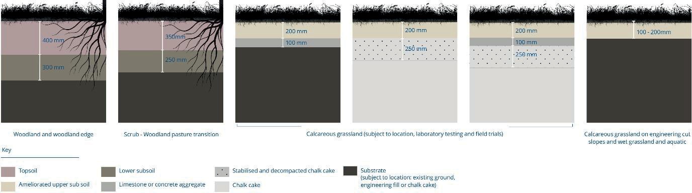
For woodland areas, fertile, nutrient-rich soils will be created with sufficient depth for rooting, over chalk ‘cake’, or drift deposits. Beyond the woodland will be transitional woodland edge and scrub habitats, where the soil profiles gradually thin and reduce in fertility through to calcareous grassland. This gradation will promote succession within the woodland habitats (accelerated through selective planting) and inhibit succession within the calcareous grassland, increasing biodiversity.
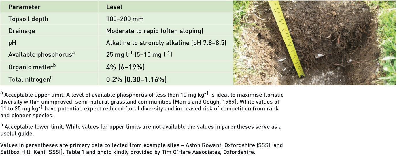
The key technical challenge is creating the necessary conditions for high quality calcareous grassland. They typically develop on shallow, low-fertility, lime-rich soils over calcium carbonate-rich bedrock, i.e., chalk or limestone [3] [4]. The soils tend to be dry, with moderate
to rapid drainage, high organic matter contents and low concentrations of nutrients, particularly available phosphorous (P) [5]. The soils usually exert moderate stress on plants through either steep slopes of >16 ° (29 % or 1 in 5.6) or drought via shallow profiles
(10−20 cm above rock), stoniness (36−70 % stones) or light textures (sand or loamy sand to
>30 cm depth or above rock) [6] (see Table 1).
From HS2 soil surveys of the site it has been identified that the upper subsoil is broadly suitable in most respects but that calcium carbonate levels are variably insufficient and phosphate levels higher than desirable to create high-quality calcareous grassland. The chalk filter cake is considered to constitute a ‘slowly permeable layer’ not inherently suitable with respect to drainage.
Solutions have been identified to these challenges, including the sustainable reuse of temporary works materials to improve the chemical and physical properties of the soils. A Technical Note [7] was prepared to detail remaining uncertainties and a research project has been commissioned by HS2 and ALIGN, in partnership with Cranfield University and Tim O’Hare Associates, to resolve these technical challenges and limit risks for the habitat creation.
Resilience through innovation
The Technical Note and proposal for the research project [8] should be read in conjunction to understand the full background and rationale for the soil profile trials. The project aims include:
- Further characterise the upper subsoil, chalk filter cake, limestone aggregate and crushed concrete.
- Identify requirement, and suitable gradings, for the potential calcareous aggregate drainage layer.
- Identify suitable material gradings, application rates and methods for the available calcareous ameliorants.
- Evaluate the efficacy of cake decompaction methods.
- Identify suitable cultivation techniques.
- Determine the requirement for, and design of (including spacing), vertical trench drains.
- Verify the performance of the soils for the habitat post-restoration.
The study scope includes the key stages illustrated in Figure 14:
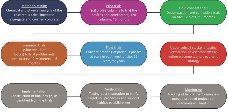
This research will be of wider applicability, both within other parts of HS2 and for other projects where species-rich grasslands are proposed.
In addition to ongoing research to inform the final restoration, there is a need to manage the soils appropriately during construction to ensure that they are maintained in a suitable condition for the proposed landscape works. Align’s works follow protocols set out within the Area C1 Soil Resource Plan [9] and HS2’s Technical Standards and specifications to maintain soil quality, and monitor compliance.
Selecting and establishing habitats
The Habitat Management Plan [10] prepared for the CVWS provides details on all target habitat types as well as planting and seeding species, a rationale for selecting those habitats as appropriate targets, as well as initial and long-term management measures.
The design team engaged extensively with the Hertfordshire and Middlesex Wildlife Trust and Natural England on all details of the landscape and ecological design.
No Net Loss
The HS2 Environmental Minimum Requirements [11] seek to achieve the goal for HS2 Phase One (London-West Midlands) of no net loss (NNL) in biodiversity for replaceable habitats at a route-wide level. In addition, there is an Assurance (no. 2097) that states:
“The Promoter will consider an area within the Hillingdon, Denham, Ickenham, Harefield and Ruislip environs within which a no net biodiversity loss target will be applied.”
This area is contained within Lot C1 and the western extent of Lot S2 and is taken to be the area between the Northolt Tunnel Western Portal and the M25 adjacent to the Chiltern Tunnel South Portal.
To gauge progress towards the goal of NNL, HS2 (in consultation with Defra and NE) developed a modified version of the Defra pilot biodiversity offsetting metric [12] (‘the HS2 metric’). The HS2 metric uses habitats as a proxy for considering losses and gains as
measured in ‘biodiversity units’ [13]. The NNL calculations generated from this metric provide the overall percentage loss or gain figures, which can be used to broadly compare different options.
Habitat creation in the CVWS area has a vital role in achieving these commitments as there is currently an 81 % gain in biodiversity units within the CVWS area in comparison to a much smaller overall gain for Lot C1 overall of ca. 10 %.
Climate change resilience
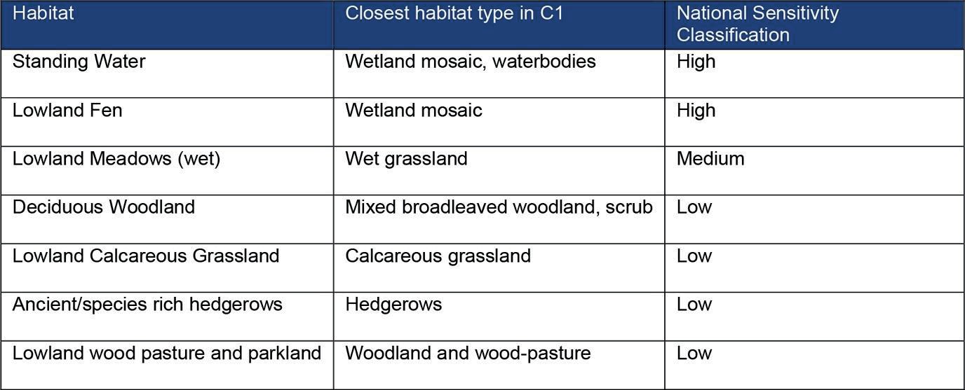
Climate change resilience has been considered during the selection of habitats and plant species to be introduced, as has the ability of those habitats to sequester carbon over the long-term (see carbon section). It is considered that the habitats and plant species are widespread across temperate Europe, and most are likely to be resilient to climate change impacts, accepting that there is significant uncertainty in predicting both potential impacts and the resilience of habitats.
Natural England and RSPB (2019) [13] includes a classification of habitat types according to their relative sensitivity to climate change. Table 2 includes those classifications for habitats selected for the CVWS project.
Calcareous grassland
The selection of habitat types reflects the topography, geology, and soils at the site and in the surrounding area. As the CVWS lie over chalk bedrock the objective is to create habitats that naturally occur over chalk, for example the mosaic habitats of grassland, woodland and scrub that occur in chalk downland type habitats.
Calcareous (usually chalk or limestone) grassland is one of the richest habitats found in Western Europe sometimes containing over 40 plant species per square metre [14]. It is a unique, and fragile habitat of international conservation importance, with the UK holding 50 % of the world’s unimproved chalk grassland; however, the habitat has declined significantly over the past 50 years, with more than 80 % loss since the Second World War [15]. The Chiltern Hills Area of Outstanding Natural Beauty (AONB) contains over 700 ha of chalk grassland [15] with the national and European importance of these areas recognised through the designation of some as Special Areas of Conservation (SACs), under the EU Habitats Directive [16].
Calcareous grassland will occupy the largest proportion of the site of any habitat type, equating to approximately 88 ha. This area would provide around 20 % of the Hertfordshire 50-year Biodiversity Action Plan target to increase chalk grassland habitat from 177 ha to 600 ha [17].
A single commercially available seed mix will be used. This will start the natural development of the grassland which will tend towards one or other of the National Vegetation Classification (NVC) [18] vegetation types listed below depending on physical and chemical parameters across the site, as well as management. This can subsequently be augmented by further seeding, addition of green hay or plug planting.
The target plant communities for open dry grassland are as follows:
- CG2 Festuca ovina-Avenula pratensis grassland
- MG5 Cynosurus cristatus-Centaurea nigra grassland
- MG1 Arrhenatherum elatius grassland
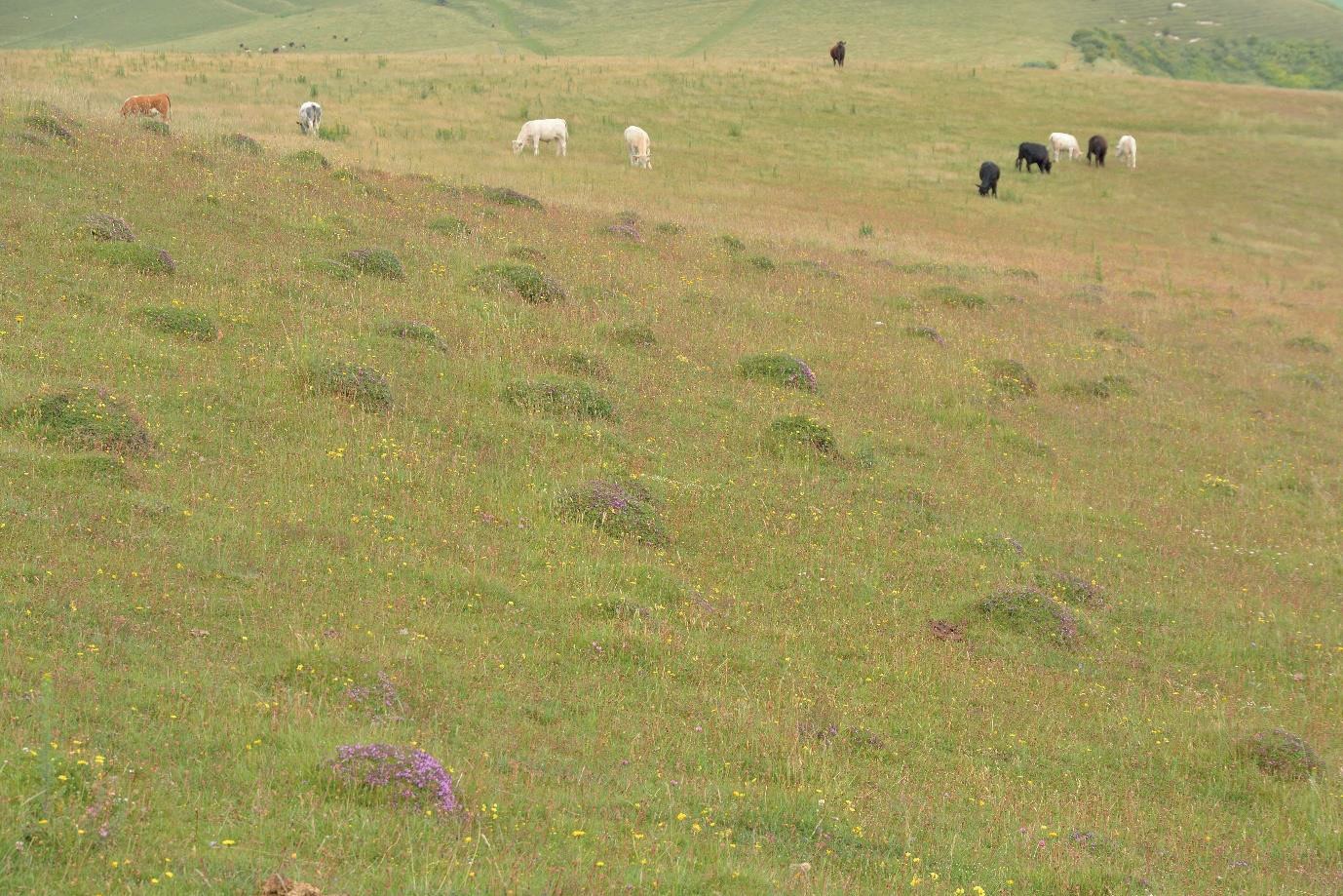
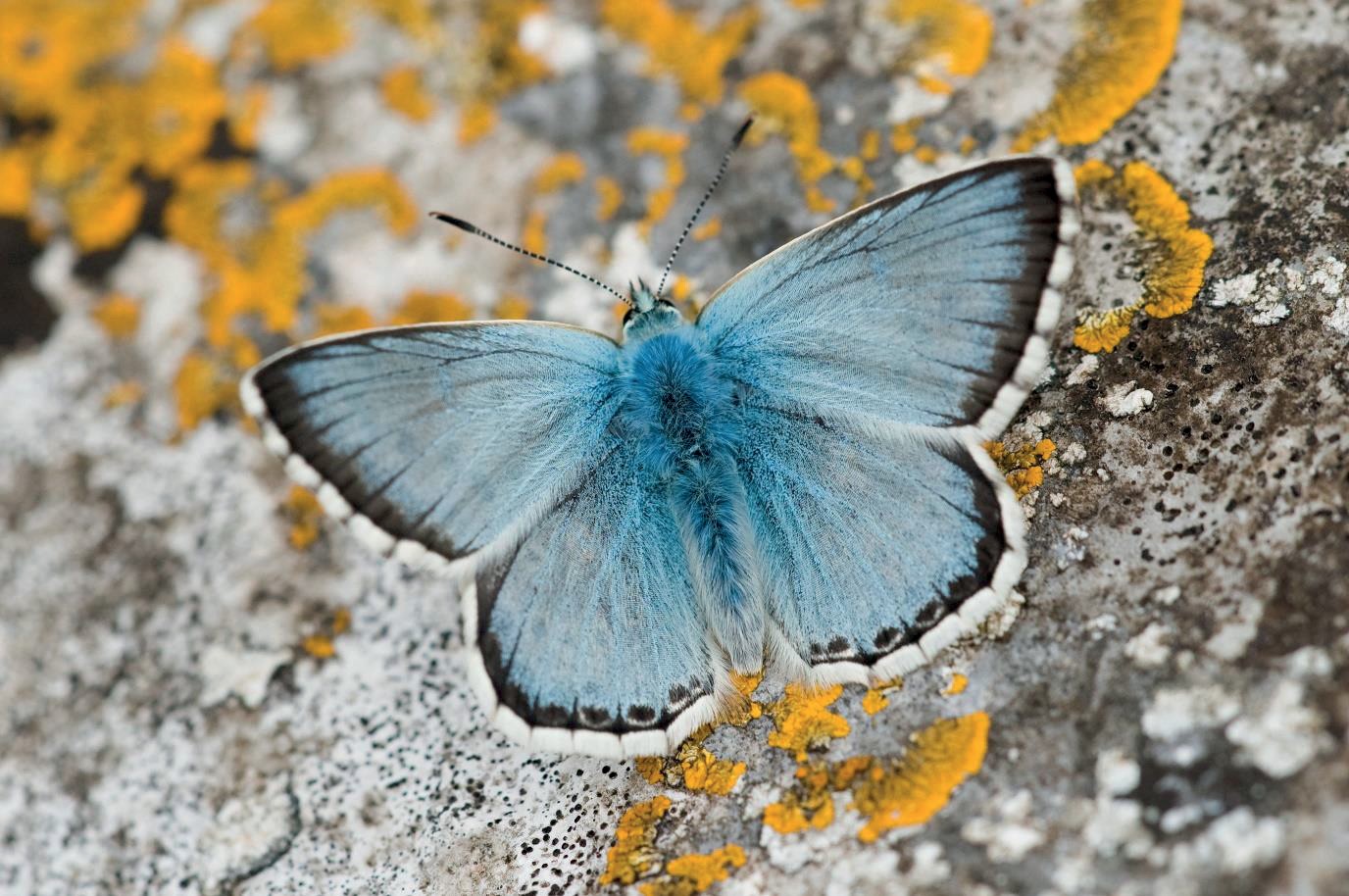
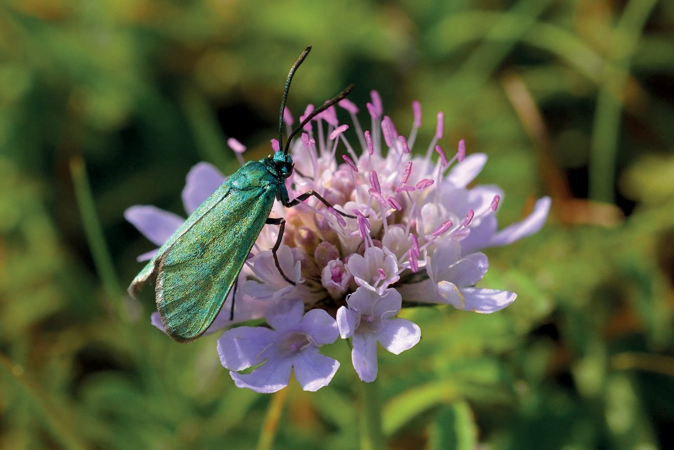
There are many key faunal species associated with calcareous grassland. The high diversity of plants that this habitat supports in turn supports a high diversity of other trophic levels particularly invertebrates, reptiles, amphibians, mammals, and birds. Figures 15-17 show a typical calcareous grassland and two invertebrate species that depend on this habitat.
Woodland
The areas initially planted as woodland will equate to approximately 26 ha. It is difficult to accurately predict how woodland planting areas will develop and look over time as it takes decades or even centuries for this habitat to mature. For this reason, specific plant communities and faunal species have not been targeted.
The species mixes have been carefully selected to reflect the context as well as the substrate/soil types, for example the inclusion of species like box Buxus sempervirens, hornbeam Carpinus betulus, common whitebeam Sorbus aria, yew Taxus baccata, and beech Fagus sylvatica.
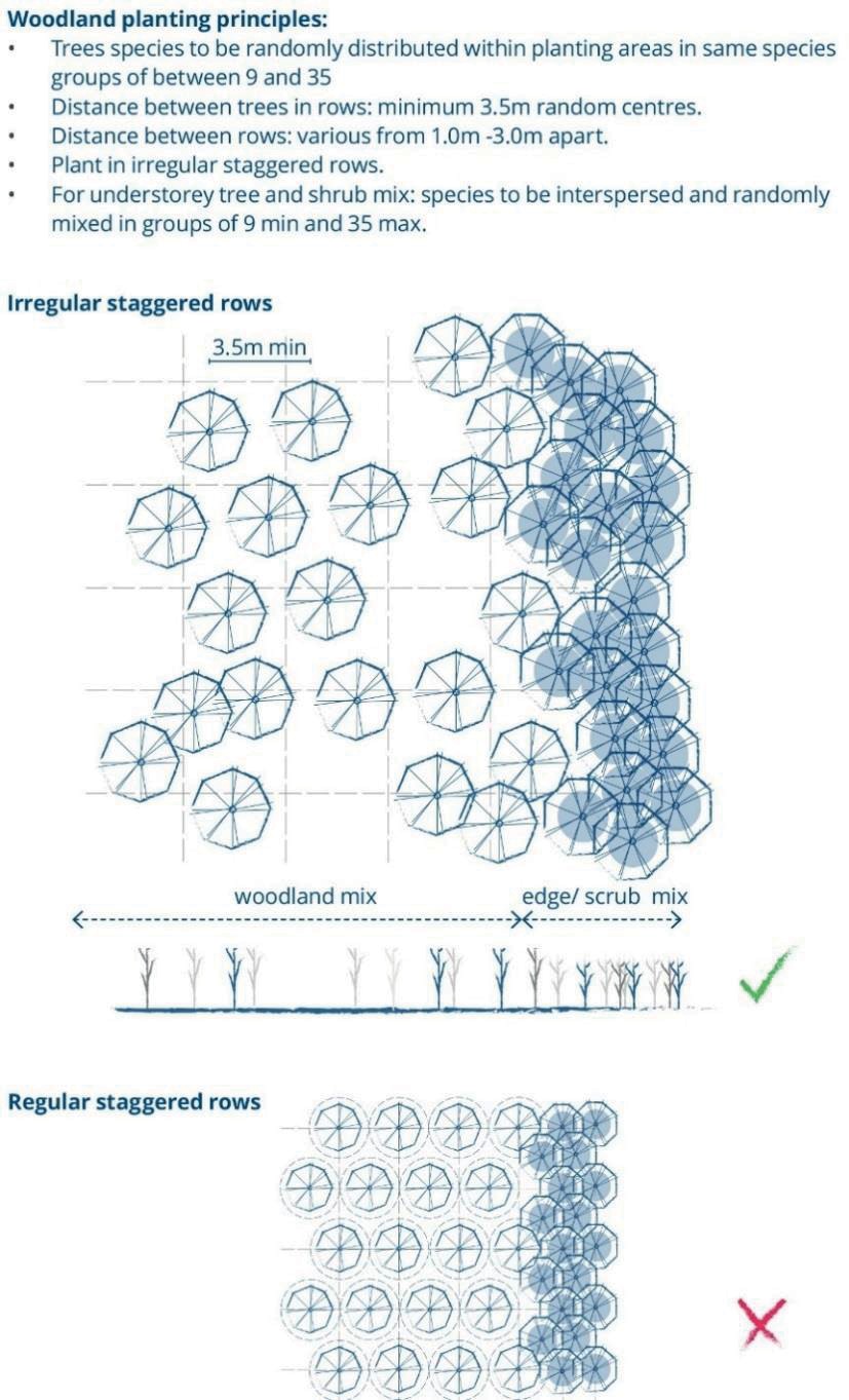
Variations in the frequency and density of planting species (for all woodland and scrub types) have been incorporated between distinct planting areas to avoid uniformity and to try to replicate a natural wooded landscape. In addition, the layout of planting will use wide planting centres and avoid geometric grids and other uniform spacings to simulate natural woodland succession (Figure 18).
Woodland edge and scrub
Woodland edge habitat has been included as a transitional habitat that will soften the edges between woodland where a closed canopy type habitat is expected to develop and scrub, where scattered vegetation will establish. As such, woodland edge planting does not conform to standard target habitat types, for example in relation to NVC communities. In terms of quantifying the areas, the initial planting of woodland edge species will equate to approximately 10.6 ha, with approximately 19.4 ha planted as scrub.
For scrub a varied mix, typical of the area, is included that are on both deeper, more fertile soils, e.g., hawthorn Crataegus monogyna, blackthorn Prunus spinosa, and bramble Rubus fruticosus, as well as on shallow, calcareous soils including: juniper Juniperus communis, common privet Ligustrum vulgare, purging buckthorn Rhamnus cathartica, sweet briar Rosa rubiginosa, wayfaring tree Viburnum lantana and guelder rose Viburnum opulus.
It is expected that scrub species will colonise areas of grassland over time but that this will be limited by the thin and poor soils, establishment of the grassland sward and by grazing pressure.
Scrub habitat is important to a wide range of species, especially when part of a diverse habitat mosaic. Key target species include species of declining ‘farmland’ birds which are naturally found in highest densities in invertebrate and seed-rich grassland and scrub mosaics, for example corn bunting Emberiza calandra, turtle dove Streptopelia turtur, linnet Linaria cannabina, and yellow hammer Emberiza citrinella. In addition, scrub supports many species of invertebrates, common reptiles, and small mammals.
Hedgerows
Hedgerow planting will include retaining and enhancing all existing species-rich native hedgerows on site and creating approximately 3.4 km of additional sections of hedgerow within the area, typically forming field boundaries and edges to roads and footpaths. The mix draws suitable species from the woodland and scrub mixes to establish some commonality.
Wetland including wet grassland
There are several reasons why the design includes wetland habitat in dry valleys which would not naturally hold water:
- Freshwater habitat dramatically increases biodiversity, especially when it interacts with other biodiverse habitats.
- Natural areas for livestock watering would be provided that will benefit from their interaction with those grazing animals; and
- There is an opportunity to use chalk from the tunnel to create an impermeable substrate that will hold water through chalk puddling.
The construction method will be trialled on site in 2022 to ensure that chalk-puddling using the chalk cake will provide a suitable impermeable liner for 10 ha of wetland habitat. Chalk and clay-lined waterbodies will be created adjacent to each other to compare the two methods.
A series of ponds, scrapes and small channels will form wetland mosaic habitats in two valley areas of the site. The aspiration is to create permanent and ephemeral/seasonal waterbodies surrounded by a wider area of wet grassland.
A diverse seed mixture which includes moisture-loving species for sowing in wet grassland areas with another for aquatic seeding has been selected. Both the wet grassland and aquatic mixtures are intended to develop into a sward most closely resembling MG8 Cynosurus cristatus-Caltha palustris grassland [18], grading from luxuriant pond-edge vegetation into damp grassland surrounding this.
The larger balancing ponds providing land drainage are also designed to function as habitat features and cattle watering points. The principles of the wetland habitat design are illustrated in Figure 19.
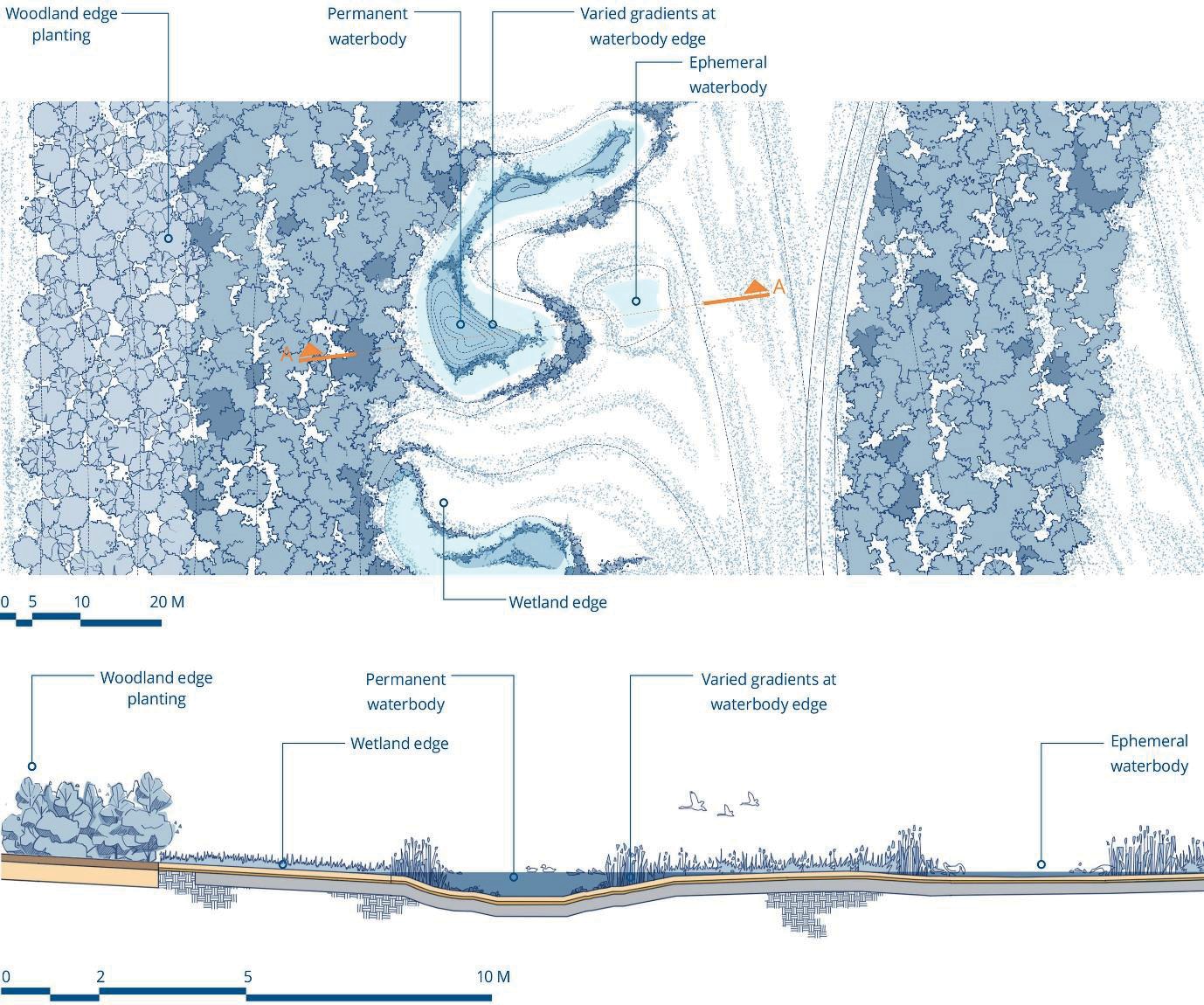
Creation of these wetlands will provide high quality habitat for a wide range of aquatic invertebrates and herpetofauna and provide feeding and nesting areas for birds such as lapwing Vanellus and reed bunting Emberiza schoeniclus, bats and other mammals.
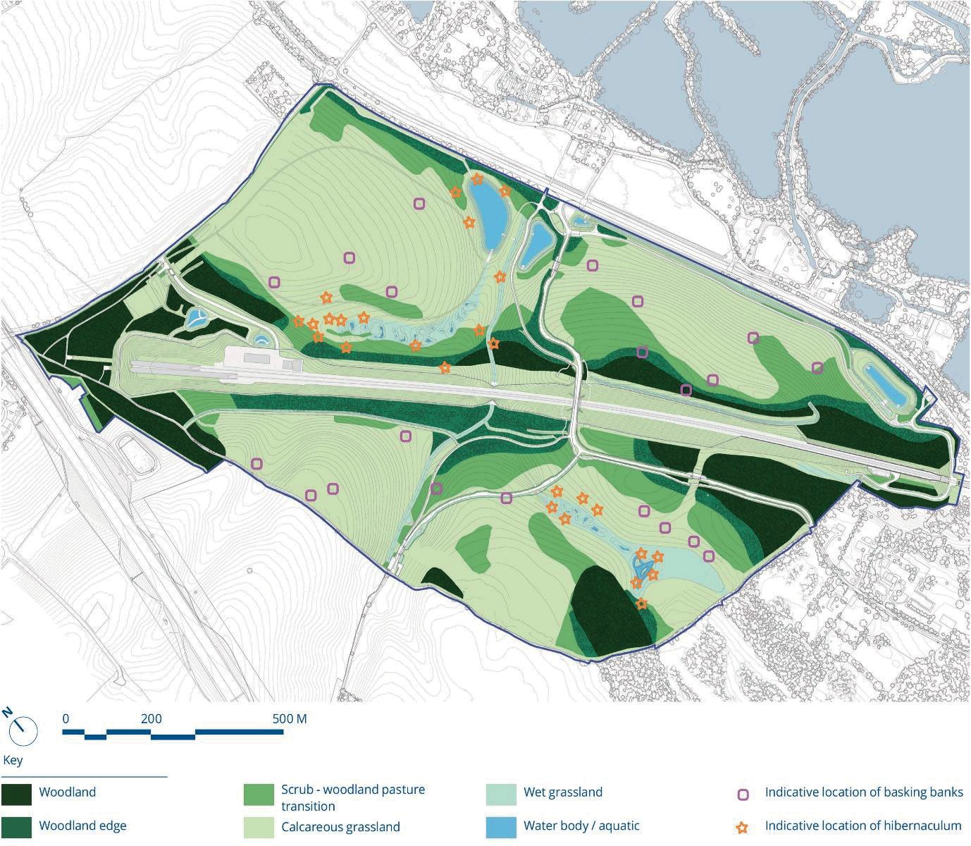
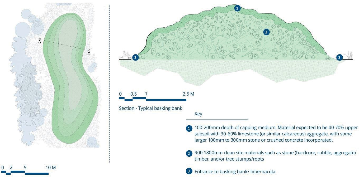
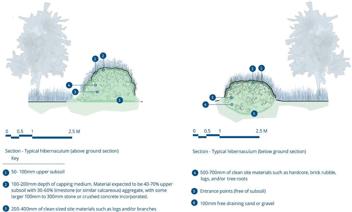
Habitat features
Micro-scale habitat features will also be included as part of the habitat design (locations for these are shown in Figure 20). Two types have been designed: reptile and invertebrate banks and hibernacula. These features will not be seeded but left to colonise naturally.
Illustrations of these features are shown in Figures 21 and 22.
In addition, there is a general aspiration to avoid even and smooth finished profiles through creating heterogeneity in habitat profiles and variation in soil depths, slope, aspect etc.
Localised variations in the slope profile will be achieved through site supervision and instruction to the contractor, rather than through detailed prescriptive specifications.
Initial management
There will be a five-year maintenance period geared towards the introduction of grazing animals once the grasslands have established sufficiently. The tree and scrub planting areas will take longer to mature sufficiently to survive grazing pressure and will be fenced for approximately ten years after planting.
The key tasks to be delivered during this stage of the project include:
- Establishment of seeded areas.
- Cutting of grasslands prior to grazing, with arisings collected and removed. Cutting will be rotational leaving small-scale mosaics of cut and uncut patches.
- Establishment of planted trees and shrubs with replanting of failed plants where necessary.
- Annual maintenance checks of hibernacula and reptile and invertebrate banks.
- Monitoring and management of vegetation growth and sedimentation in wetland areas.
- Control of invasive plants.
- Maintenance of temporary and permanent fencing and livestock infrastructure.
The consideration of climate change and the associated resilience of the planting/seeding has been an important driver in both the choice of species and approach to management, and to the procurement process [19] [20] [21] [22].
Long term management
An adaptive management approach will be used, with broadly defined rather than unnecessarily prescriptive target habitat types. This approach recognises the uncertainty of habitat creation and the long timescales over which the target habitats will develop and allows for natural processes to operate and to develop over time.
The habitat creation is designed to support the needs of long-term management, and specifically extensive conservation grazing, the key management tool. Consideration of the limitations and constraints of the site has led to a mature design that can deliver natural habitats that support largely un-managed free-roaming livestock that would not require supplementary feeding or watering year-round. This ‘rewilding’ approach to grazing is known to be important to help establish natural processes that lead to high biodiversity and increased carbon sequestration [23] [24].
The following general principles will be followed:
- Cattle are the preferred livestock currently, at a density of ca. 0.5 head per hectare, with stocking managed to optimise levels of grazing and welfare.
- Supplementary feeding and watering will not be provided, unless deemed essential for animal welfare reasons.
- Livestock will be present year-round with minimal management.
- Livestock should be able to move freely around the site without human intervention, although the necessary infrastructure to allow managed and un-managed movement is available, if the need arises.
- Fencing of tree/scrub planting areas will be removed or opened, when appropriate, to allow wood pasture habitats to develop.
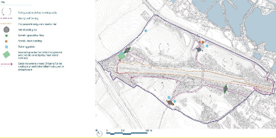
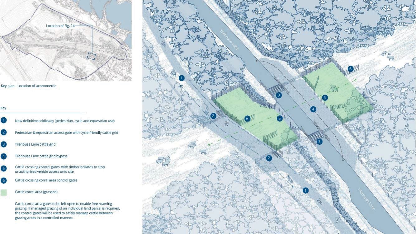
Infrastructure necessary to manage livestock will be provided as part of the main contract works and will include four corrals; three pairs of cattle grids (on Tilehouse Lane and the quarry access road); stock fencing and gates; and water troughs. The location of these features is illustrated in Figure 23, while a typical arrangement and principles of corrals and cattle grids is illustrated in Figure 24.
Passive provision for a larger cattle management area is provided in proximity to the Chiltern Tunnel South Portal. Additional infrastructure such as cattle shelters will also be considered as part of later and separate applications.
Carbon
Habitat creation potentially influences the carbon footprint of the project in two ways:
- Carbon sequestration: the habitat type for each land parcel influences the amount of carbon that can be stored within the soil; and
- Carbon impacts: result from embodied carbon of the materials, transporting them to site, reprocessing them on site, and the carbon from plant and equipment used to place the materials on site.
Full details of the sequestration and carbon impact analysis are provided in the CVWS Option Appraisal report with the results summarised below.
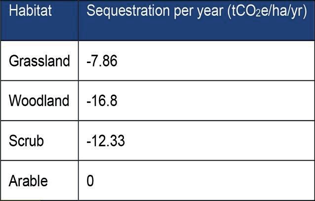
Tables 3 and 4 show that creation of natural habitats in place of arable land dramatically increases sequestration with an additional -54, 317 tCO2e sequestered – estimated to be ca. 7 % of the Lot C1 carbon impact. The additional sequestration of -12,799 tCO2e between the Scheme Design and Detailed Design stages results from an increase in land reinstated to natural habitats.
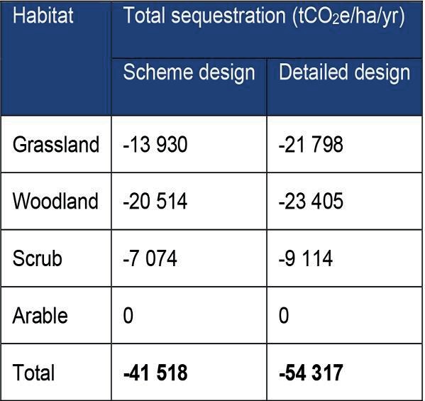
In comparison the carbon impact related to the embedded carbon of the materials as well as their transportation and processing is estimated to be +4,681 tCO2e.
A place for people
The CVWS represents an opportunity to create, at scale, a well-connected and diverse community space which provides access to the natural environment, and which can contribute meaningfully to promoting health and well-being and active green travel.
Proposals include several new footpaths, a cantering track, cycle routes and bridleways together with the realignment and partial upgrade of existing rights of way impacted by the railway. These routes will be connected to the wider footpath and cycle network where they interface with the CVWS boundary and will form part of a broader recreational offer which will be delivered by the HS2 project (see Figures 25-26).
In addition to designated public rights of way and informal paths, there will be areas of open access land for informal recreation. It is assumed that access to the west of the railway will be restricted, to prevent human disturbance of natural habitats. This will be decided by the land management organisation on an ongoing basis, informed by monitoring.
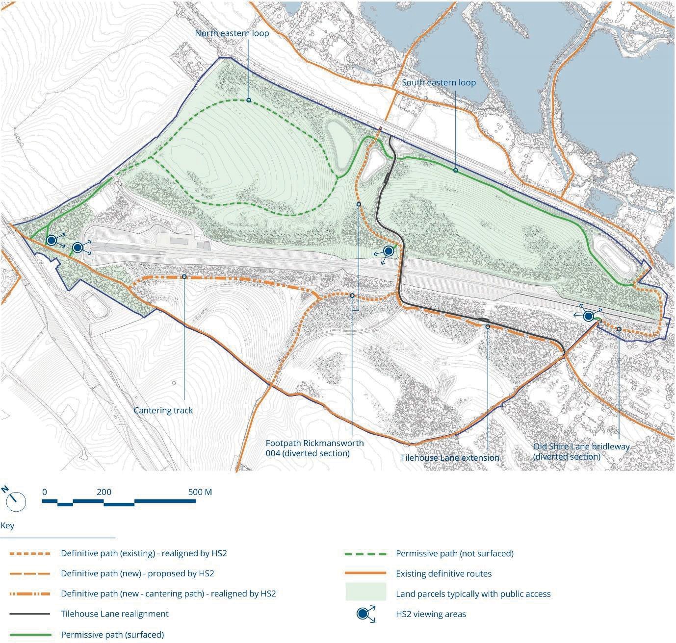
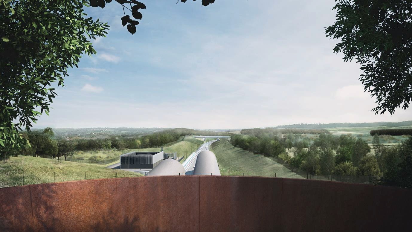
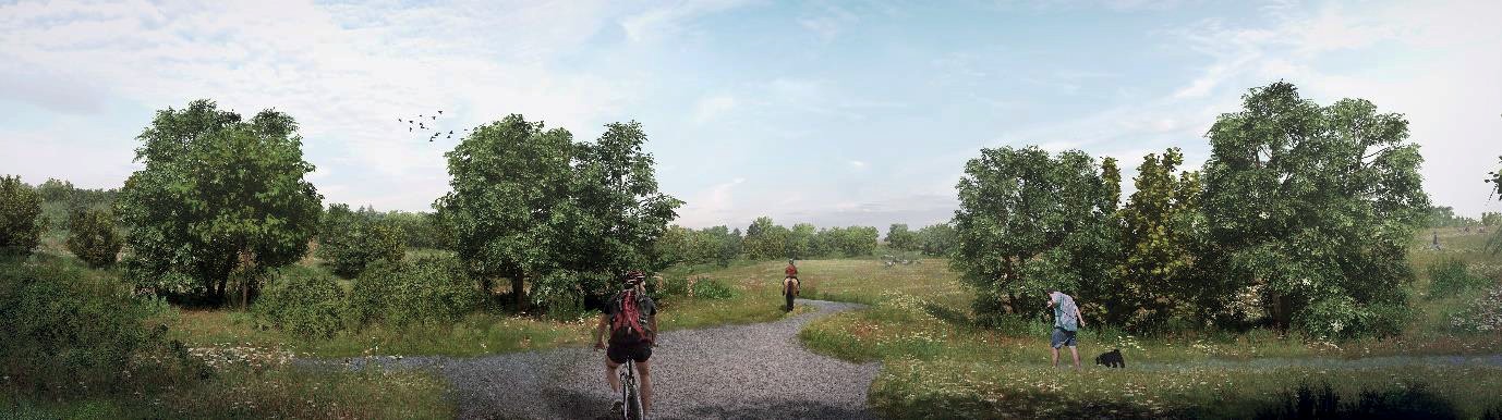
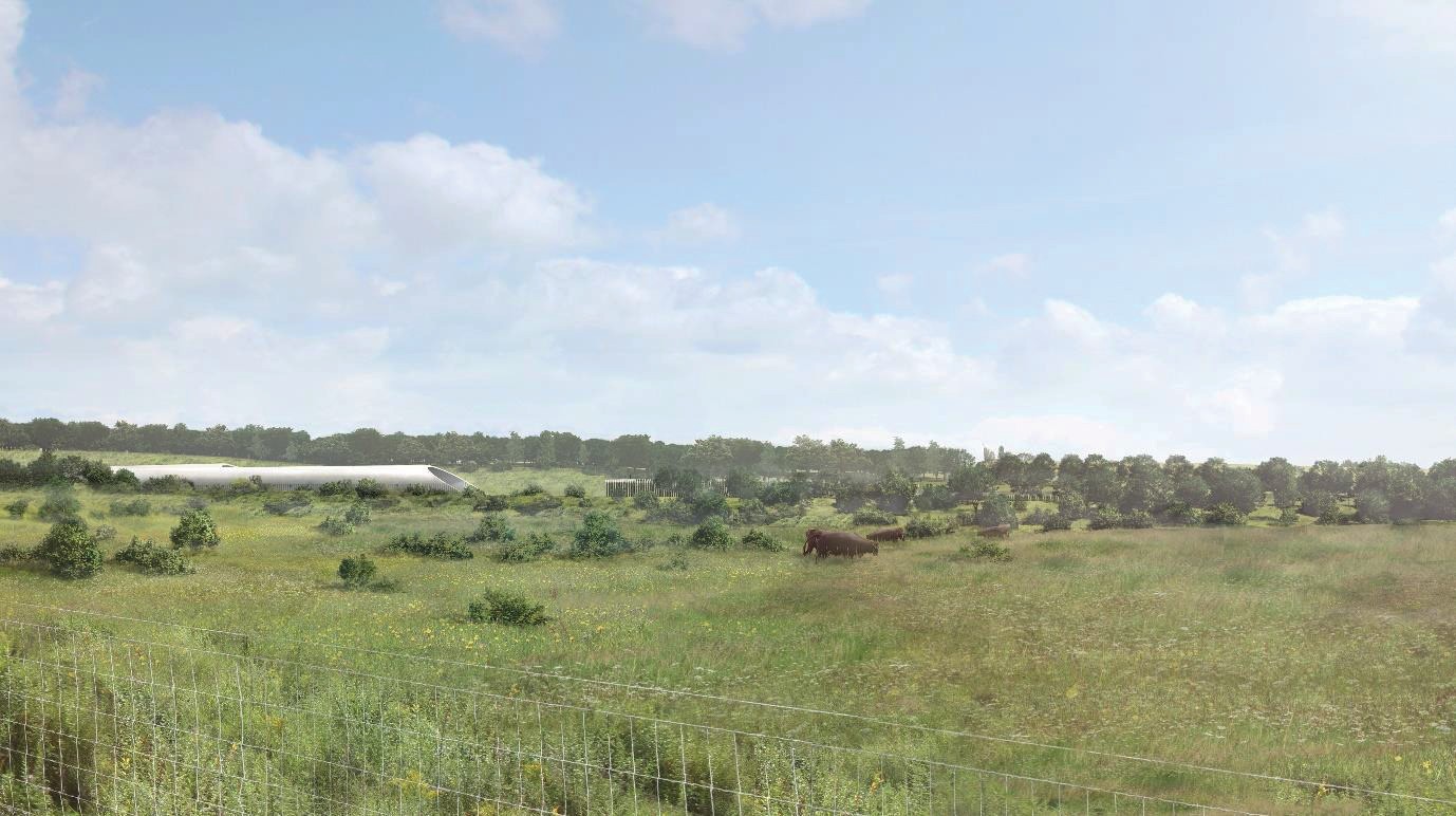
The ‘visitor experience’ will include opportunities to view the railway from three ‘set piece’ locations, connected by the footpath network, at the Chiltern Tunnel South Portal; adjacent to the Tilehouse Lane Overbridge; and at the CVV North Embankment. Views of the CVWS from the wider landscape have also been considered. Figures 27 to 29 provide a snapshot of the visitor experience at year 15 after construction.
Project legacy
The design is predicated on a compelling narrative about landscape scale change which when implemented will contribute positively to much broader challenges including climate change and biodiversity resilience; sustainable use of natural resources; health and well- being; importance of place, community, and identity; and working with nature and natural processes to craft a landscape which will endure. The design is fully grounded in the practicalities of delivery and long-term management and strikes a balance between public amenity, operational requirements for the railway and protection of nature.
The design is underpinned by a collaborative and multi-disciplinary approach, drawing knowledge and expertise from key stakeholders, research organisations and professional bodies. The team has sought to deliver innovative design and construction solutions which can be adopted and replicated across other large scale infrastructure projects bringing cost savings, a reduction in carbon impacts, and a focus on nature recovery. This includes the sustainable reuse of construction materials to create soil profiles; maximising carbon sequestration through well-planned soil and habitat creation design; and adherence to rewilding principles to guide landscape establishment, natural regeneration, and sustainable long-term management.
The project has been the subject of recent national media attention[26] and was also included as an exemplar of sustainable infrastructure design within HS2’s submission for the COP26 summit held in November 2021.
The project was shortlisted within the Environment and Sustainability Initiative of the Year at the British Construction Industry Awards 2021 and was a finalist in the Excellence in Sustainable Infrastructure category of the Landscape Institute Awards 2021.
References
- High Speed Two Limited, (2013a). HS2 Phase One environmental statement volume 2: CFA7 Report – Colne Valley. November 2013.
- Align (2020). Use of limestone aggregate in preference to recycled aggregate for haul roads and compounds. Document no: 1MC05-ALJ-EV-REP-C001-000077
- Blakesley, D. & Buckley, P. 2016. Grassland Restoration and Management. Exeter: Pelagic Publishing, UK.
- Rodwell, J.S., Morgan, V., Jefferson. R.G et al. 2007. The European context of British Lowland Grasslands. JNCC Report, No. 394.
- Forest Research. 2014. Lowland Calcareous Grassland: Creation and Management in Land Regeneration.
- Natural England. 2010. Higher Level Stewardship: Farm Environment Plan (FEP) Manual. Technical guidance on the completion of the DEP and identification, condition assessment and recording of HLS FEP features (Third Edition).
- Align (2020). Technical Note on Habitat Creation Designs for Western Valley Slopes. Document no: 1MC05-ALJ-EV-NOT-CS01-210014
- Align (2021). Research Proposal – Soil Profile Trials to Support Calcareous Grassland. Document no: 1MC05-ALJ-EV-REP-C001-000104
- Align (2021). Area C1 Soil Resource Plan. Document No. 1MC05-ALJ-EV-REP-C001- 610273
- Align (2021). Habitat Management Plan Colne Valley Western Slopes. Document no: 1MC05-ALJ-EV-REP-CS01_CL02-214001
- Gov.uk – HS2 Environmental Minimum Requirements
- Defra (2012) Biodiversity Offsetting Pilots: Technical Paper: the metric for the biodiversity offsetting pilot in England. Defra
- HS2 (2017) No net loss in biodiversity calculation – methodology and results (2017 baseline). Document no: 2DE02-ACI-EV-REP-L000-000005
- Natural England and RSPB, 2019. Climate Change Adaptation Manual – Evidence to support nature conservation in a changing climate, 2nd Edition. Natural England, York, UK.
- National Trust – What’s Special About Chalk Grassland
- The Chilterns Conservation Board – About Chilterns Chalk Grassland
- Council Directive 92/43/EEC of 21 May 1992 on the conservation of natural habitats and of wild fauna and flora. Available from:
- Biodiversity Partnership (2006). A Biodiversity Action Plan for Hertfordshire – A 50-year vision for the wildlife and natural habitats of Hertfordshire.
- Rodwell J.S. ed. (1992) British Plant Communities Volume 3 – Grassland and Montane Communities, Cambridge University Press
- HS2 Technical Standard – Climate Change Adaptation and Resilience. Document no: HS2‐HS2‐SU‐STD‐000‐000003
- HS2 Technical Standard Plant Procurement Specification. Document no: HS2-HS2-EV-STD-000-000018
- HS2 Plant Procurement Strategy. Document no: HS2-HS2-EV-STR-000-000005
- HS2 Technical Standard – Lawn, Meadow and Wetland Plant Procurement Specification. Document no: HS2-HS2-EV-STD-000-000019
- Rewilding Europe (2015). Natural Grazing Practices in the rewilding of cattle and horses.
- English Nature (2005). Large herbivores in the wildwood and in modern naturalistic grazing systems English Nature Research Reports, Number 648.
- Alonso, I., Weston, K., Gregg, R. & Morecroft, M. 2012. Carbon storage by habitat – Review of the evidence of the impacts of management decisions and condition on carbon stores and sources. Natural England Research Reports, Number NERR043.
- The Guardian (3 Mar 2021) –HS2 to ‘rewild’ 127 hectares around its 10-mile Chilterns tunnel
Peer review
- David GreenHS2 Ltd
- David Prys-JonesHS2 Ltd
- Declan RooneyHS2 Ltd
- Patricia HawesHS2 Ltd