Fundamentals of Habitat Creation: Wildlife Ponds and Woodlands on HS2
This document outlines good practice and lessons learned during the design and creation of ponds and woodland for wildlife mitigation and compensation on HS2.
The Enabling Works Contractors (EWC) on Phase One designed and created new woodlands equivalent to over 245 football fields and created over 180 new wildlife ponds to mitigate and compensate for the impacts of the scheme on wildlife.
There have been many successes, and there are some areas of design, programming and construction which can still be further optimised across the industry. These points are explored in the paper.
This information will help inform future work on HS2 and will be of interest to other people and organisations involved in environmental design, planning, and implementation.
- Written by
-
Clare Pugh (AtkinsRéalis/HS2 Ltd (EDP))

-
Tom Stroud (Arup/HS2 Ltd)

- Resource type
- Resource type: Technical Paper
- Tags
- environment posts
Background and industry context
Inevitably, the construction and delivery of HS2 will leave a footprint on the countryside. This is something that is carefully managed during its design and construction, including the delivery of long-term improvements to the environment. HS2 is building a Green Corridor which will integrate the high-speed railway into the surrounding landscape, and create a network of bigger, better-connected, climate resilient habitats and new green spaces.
Providing habitats to mitigate and compensate for impacts on wildlife is common to most development projects and infrastructure schemes, but the scale of HS2 sets it apart. HS2 has already planted new woodlands equivalent to over 245 football fields and created over 180 new wildlife ponds, before a single train has started running.
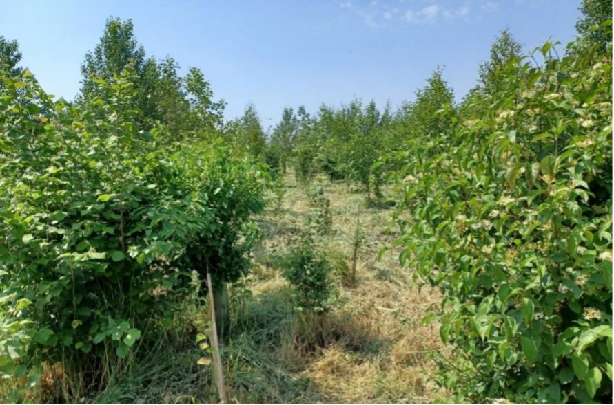
These early sites were primarily designed to act as receptor sites for protected species, such as great crested newts and reptiles, and to provide foraging habitat, roosting opportunities and flightlines for bats. Finham Brook Valley ecological mitigation site in Warwickshire, is an example (see Figure 1), covering approximately 4.0 hectares (ha) of previous agricultural land where six new ponds have been created for great crested newts to breed in, species-diverse grassland has been created to support local wildlife, and over 6,200 new trees have been planted featuring native locally occurring species such as English oak, hazel, common hawthorn, and holly.

Approach and Outcomes
HS2 has been designed to avoid or reduce adverse impacts on habitats, protected species, and other features of ecological value, where reasonably practicable. Where adverse impacts cannot be avoided, mitigation and compensation measures have been included to reduce effects on species and habitats. These mitigation measures are specific to the nature of the impact and species affected and are detailed in the Environmental Statement[1].
Impacts on some protected species, such as great crested newts, can be mitigated by translocating the individuals to newly created habitats to maintain their favourable conservation status. New habitats need to mature before they can receive translocated protected species. For example, the HS2 Phase One route-wide great crested newt licence[2] contains a condition that all compensatory habitats must be created a minimum of six months in advance of its required use, with only months within a plant growing season counting towards this minimum period (March – September inclusive). It also takes time for woodland and scrub planting to establish and support species, and therefore early planting was completed wherever possible. Due to the lead-time required, the design and creation of early habitat creation sites was carried out by the Enabling Works Contractors (EWC), who were appointed in 2017 and created wildlife habitats between 2018 and 2021. The location of early sites was
constrained as they needed to be within the range of species populations affected and within the HS2 Act [3] limits, where they would not be subject to other construction works, such as temporary stockpiles. The habitat creation sites include, but are not limited to, woodland, wildlife ponds, grassland, hibernacula (refuges) and basking banks. These sites are spread across the scheme, but they will eventually be linked as part of the Green Corridor by Main Works Civils Contractor (MWCC) planting which is the following, and largest stage, of habitat creation where lessons learnt, particularly on the design and creation of wildlife ponds and tree planting, will be implemented.
Wildlife ponds
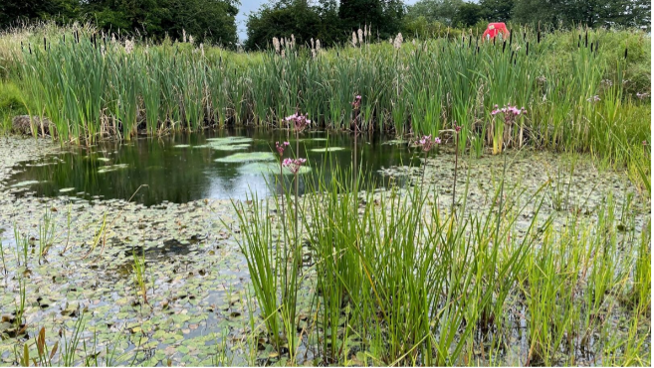
Many of the newly created ponds have been successful, with good water levels and established aquatic and marginal planting (see Figures 2 and 3). Establishing new ponds is harder in cases where there are low water levels and associated poor aquatic plant establishment, as well as high nutrient levels and associated algal growth.

Ponds were established in challenging conditions, having been built in 2018, between periods of severe drought in 2018 and 2019. With increasing impacts from climate change and variation in rainfall intensity, low pond water levels are an issue for wildlife that rely on ponds to hold water for much of the year and in successive years. Ideally, ponds would be built before the winter, so they fill with winter/spring rain although this does not ensure ponds will hold water permanently.
Bringing water in tanks by road to fill ponds was avoided wherever possible due to cost, sustainability, the lack of access in rural locations for large machinery and the lack of sources of unchlorinated/treated water. A very few ponds were filled from local waterbodies such as streams and agricultural reservoirs using pipes and pumps. It is possible to abstract up to 20 cubic metres per day from waterbodies without needing an abstraction licence from the Environment Agency[4], although the water sources need to be close enough to facilitate pipes and pumps into the pond and filters may be required to prevent undesirable species such as fish from entering the ponds. This also needs to take account of local conditions; in drought conditions abstracting from watercourses which already have low water levels may affect the local aquatic habitats, even at low volumes.
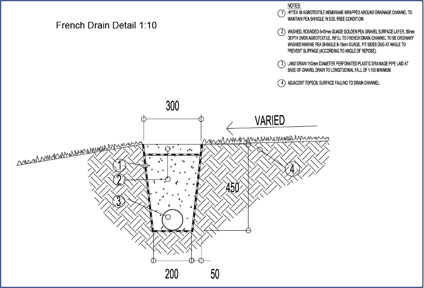
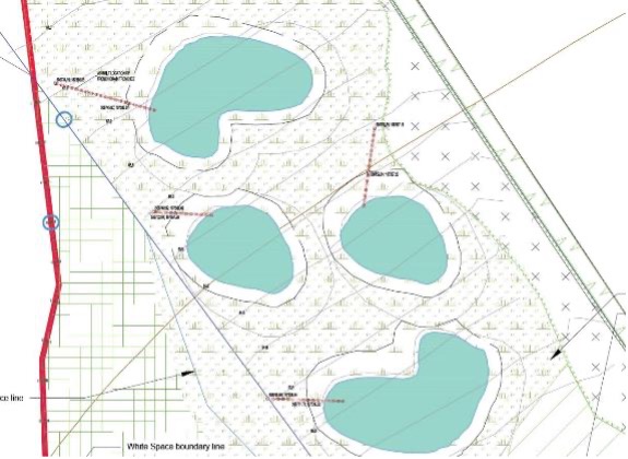
Costain Skanska Joint Venture (CSJV), one of the Enabling Works Contractors (EWC), were tasked to design and build an ecological mitigation site in Greater London. The site was designed as grassland with four wildlife ponds and two hibernacula. Construction started in April 2018. Issues with ponds retaining water to a satisfactory level were recognised throughout their establishment period in 2018 and 2019. The designers advised use of subbase material as lining, which was subsequently found to be inadequate to hold water. A bentonite liner was subsequently installed to rectify the problem. However, the location of the ponds did not encourage natural water fill from surface drainage so French drains were installed on three of the four ponds to intercept surface water run-off and channel this to the ponds, reducing the need to import water (see Figures 4, 5 and 6).

As part of continuous improvement, an attenuation tank system to control pond water levels was trialled on Phase 2a (see Figure 7). This involved the design and installation of shallow Geocellular attenuation tanks to provide resilience to the pond water levels. The tanks harvest direct rainfall from the tank surface area, and store this, with a direct connection to the pond to release stored water and maintain a minimum water level of 50 cm. This system was only used as a last resort on constrained sites, where hydrological assessments suggested they were required.
Some ponds on Phase One were designed with steep sides and few shallow edges. This created a large drawdown zone on the banks which can cause drying out and failure of marginal plants. Ponds with shallow, marshy edges are likely to be less affected by marginal plant failure. To help aquatic plants to stay wet, one option is to plant aquatics over two seasons, for example plant at one level in the first season and then at a higher level in the second season as water level rises.
Natural England’s Great Crested Newt Mitigation Guidelines [5] suggest that ponds for great crested newts should have a surface area of 100 m2 – 300 m2. HS2 have found that although the positioning of ponds is key, larger ponds are more successful and are less likely to dry out due to their greater water holding capacity and high volume to surface area meaning they are less subject to water losses through evapotranspiration.
HS2 avoided aggressive plant species in the planting specifications, such as bulrush or great reedmace (Typha latifolia) and common reed (Phragmites australis), as these can quickly fill open water, overshade and outcompete desirable plants, and have a high water demand, exacerbating the issue of low water levels. However, these species colonised naturally within some of the ponds (see Figure 8), particularly those with lower water levels, and needed to be addressed as part of the maintenance and management activities.
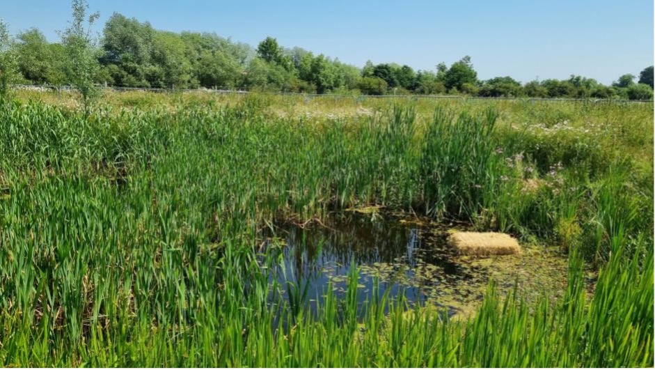
Algal blooms were experienced at some of the ponds, during the summer months, due to nutrient rich conditions (particularly where ponds had been built on previous agricultural land) and these were treated with barley straw (see Figure 8). For longer-term management, it is important to consider the land use in the catchment area. If the catchment area is currently or historically agricultural, algal blooms in ponds are likely to be exacerbated by nutrient-rich runoff.
In cases where ponds which were not required to mitigate or compensate for great crested newts, were not holding water, even after remedial measures, the ponds were reclassified as ephemeral scrapes. Although such ponds still have value for wildlife they are not considered as wildlife ponds.
Using the above key lessons learnt on HS2, a pond design checklist (Table 1) has been created to aid future design.
Table 1: Pond design checklist
| Consideration during design | Further information |
| Rainfall and evaporation rate | If designing rain fed ponds, the rainfall needs to be higher than potential evaporation rates for the site. If it is not, there will be reliance on runoff from surrounding fields, which in turn will depend on catchment and topography. The design may need to incorporate surface drainage or earthworks to encourage runoff to flow towards the ponds. Very small sites may not have enough catchment area to collect the water required to fill the ponds. Estimates of rainfall and evaporation rates on sites can be determined through consultation with the guidance document “Estimation of Open Water Evaporation”, published by the Environment Agency [6]. With knowledge of the site location, the MORECS square and thus the average evaporation rates from grassland and open water can be determined. Rainfall data can be gathered from various sources online, either from the MET Office, Environment Agency, or National River Flow Archive [7]. |
| Topography of site and catchment areas of each pond/pond cluster | If the design relies on rain or surface fed ponds, the design should ensure the topography of the site falls toward the pond and that there is enough to keep the pond topped up. If there are other natural or man-made ponds in the area upstream of the proposed pond location, they may intercept any surface water run-off before it can get to the pond. If a site is designed with several ponds, siting is important so that the first ponds downslope do not intercept all the drainage, before it reaches other ponds. Where there are several ponds on a single site, spillways or simple channels between ponds could enable water to be “shared” more equally. Ideally, detailed topographic survey information will either have been collected prior to, or as part of the pond design process. Failing this, LIDAR data [8] can be used to give an oversight of the shape of the site in question; the National Library of Scotland has an online map viewer with 1m resolution DTM files available [9]. When considering the catchment area of each pond, any pre-existing land drainage needs to be considered. Similarly, if the existing topography will not encourage surface water runoff to gather in the pond(s), the inclusion of drainage networks, either piped or simply through the incorporation of shallow scrapes and channels will augment flow to the pond(s). |
| Vegetation cover of catchment | Be aware that the surface (or roughness) of the ground will affect how quickly surface water will run toward the pond (rougher ground such as woodland or grassland will slow run-off and infiltration to ground may occur before the water reaches the pond). Sources of information: Land use cover, aerial photography, ecological baseline surveys. |
| Infiltration rates of underlying soils and superficial geology | Ground investigation will determine what materials are in the ‘dig zone’ and whether these are likely to hold water. Granular material below the surface will allow water to seep away. The need for liner should be determined on a site-by-site basis subject to local conditions using information on soil conditions and permeability tests to input to the design. HS2 have a hierarchy of preference, from best to worst, of unlined ponds > puddled clay > bentonite clay > plastic or butyl liners, with the latter only considered as a last resort. It is very difficult to make accurate estimations of infiltration rates without site-specific testing. An understanding of the anticipated soils and superficial deposits present on site (using the data sources detailed later in this table) will potentially give bulk permeability figures that can be used to calculate infiltration rates, but these may result in either over- or under-estimations of these rates. As a minimum, a soakaway test should be carried out at the site of the proposed wildlife pond(s); for small sites, a single test may be sufficient but larger sites may require further tests to suitably characterise the ground conditions across the site. The soakaway tests should be carried out according to the guidelines of BRE 365[10]. |
| 4Ground water levels | If the proposed ponds are to be groundwater fed, information is needed on the likely groundwater levels throughout the year. In summer groundwater could drop below the base of the pond leaving it dry in summer and conversely it could overtop in winter. Information is also required on the geology in the location, such that it will allow groundwater to reach your pond and will not be blocked by local variations. Ground investigations should be a source of information. Borehole logs will provide information on the soil and superficial geology encountered, along with the level of any groundwater strikes. If monitoring standpipes have been installed, it should be possible to retrieve long-term monitoring of groundwater levels. The British Geological Survey (BGS) provide detailed geological maps online, along with scans of historical borehole logs[11]. Soil data can also be found online [12]. |
Tree planting and woodland creation
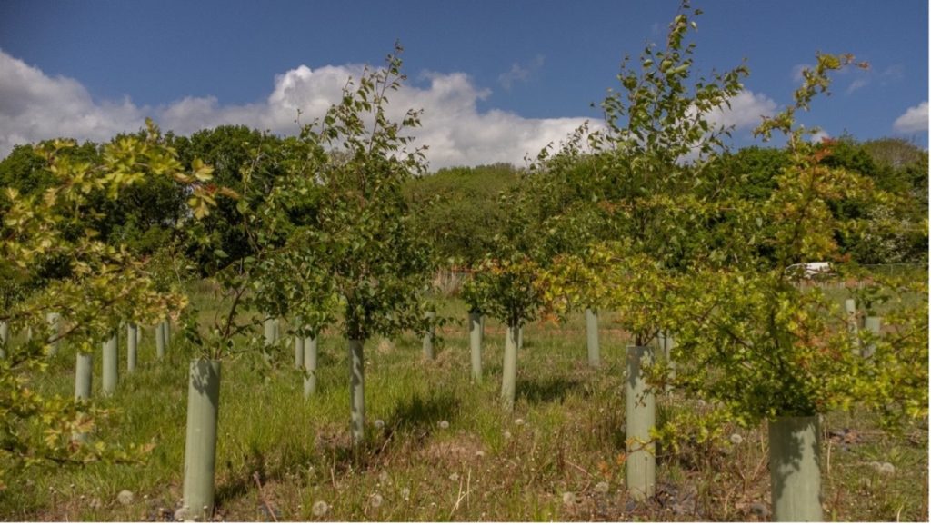
It can be surprisingly hard to plant and successfully establish trees and shrubs which meet the intended objectives in an expected timeframe, especially when undertaking a planting programme on the scale of HS2. There have been many successes (see Figures 9 and 10), but equally there have been several areas with low tree and shrub success rates which have needed replanting.
There are numerous reasons why tree establishment may not be successful such as issues in design and layout, choice of species and availability of trees, timing of planting, aftercare and grazing pressure. It can be difficult to prove which of these factors, or combination of factors, was the key reason for tree failures on a specific site. The following sections discuss key lessons learned from the HS2 Phase One design and implementation of tree and shrub planting, including how HS2 is managing the procurement and supply of large qualities of trees and shrubs.
The Right Team
It is critically important to have an experienced and knowledgeable design team who understand the practicalities of habitat creation, the complexities of tree planting, and how landscape specifications and the implementation of large-scale planting programmes should work. This may involve ecologists, landscape architects, soil scientists and hydrologists.
Experience has identified challenges when programmes are led by delivery focused managers without the input of such specific subject matter expertise, who typically do not understand the seasonality and practicality of habitat creation and the requirements for ongoing habitat management.
To mitigate this issue, to raise awareness of the risks, and upskill the knowledge of the team ahead of the planting programme, the whole team needs to be informed of the procurement timescales, the proposed implementation programme (including clarity of the planting seasons), and the potential risks and pitfalls associated with tree planting. This should be done at an early stage of the project and can be undertaken using some simple presentations that are presented by subject matter specialists.
Programme and procurement
Hitting the planting season (typically November to March) is fundamental to the success of large-scale tree implementation and establishment. During the planning stages, balancing programme requirements and advanced tree stock procurement is one of the most important (and difficult things) to get right on a large project with multiple conflicting pressures.
Programming and procurement need to be considered early to ensure successful implementation so that the habitats created have the best chances of success. Typically, across the early habitat creation sites, optimal planting seasons were targeted, but were not always achieved, largely due to land access issues.
Following the design stages, the process of planning for tree planting can be split into two core areas: the advanced forecasting and procurement of tree stock, and the process of programming the physical planting of the trees.
There are large lead times for tree procurement on HS2 (or any such major infrastructure project), and as such this needs a high level of advanced planning. Growing Instructions (schedules of plants) are required by the nursery two to three years in advance of the required planting season to facilitate a suitable timescale for seed gathering and the subsequent growing of the trees to specification. Where detailed designs are not available with tree planting specifications, the order needs to be based on professional judgement of plant species and sizes likely to be needed.
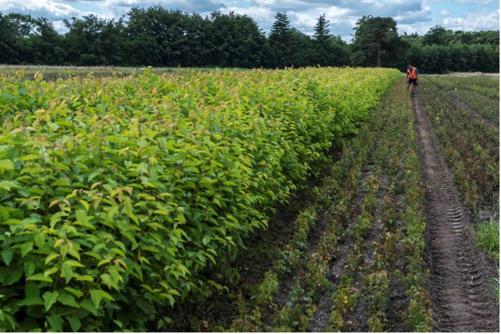
HS2 facilitated this process with one single nursery supplier to provide the plant material across the route. All HS2 trees and shrubs are grown from native seed in the UK by Crowders, a nursery based on a 140-hectare site in Lincolnshire. This has helped control the consistency of plant quality and biosecurity, and equally this has aided the simplicity of stock logistics using a single source. Figures 11 and 12 show the nursery and some tree stock growing for HS2. HS2 Contractors must confirm and call off the plant orders with the nursery confirming species, numbers, and sizes at least three months in advance of site delivery to inform the logistics of tree lifting and delivery.
The tree planting season is generally acknowledged as November to March given a suitable window of preferable climatic conditions. Ideally planting would be carried out in early November, or at least before Christmas, when soils are still warm and will get wet. Planting later in the season (January to March) although achievable, can lead to cold, hard, dry soils, which if followed by a dry spring or summer can increase failure rates. In this scenario root establishment will compete with the trees growing foliage or flowers, and this competition will jeopardise the establishment of roots and the overall survival chances of the trees. This is particularly risky in relation to planting bare root whip stock. A whip is a plant with single stems/centre leader, between 40 and 90 cm tall and with few or no sideshoots/side branches.
Late or out of season planting, can lead to increased maintenance demands, such as the requirement for increased watering, which is expensive, not sustainable, and ultimately it can be easier to selectively replace small volumes of failed plant stock. However, seasonal and location specific flexibility does need to be considered, for example, 2022 was a hot and long summer, therefore in some scenarios the late autumn/winter planting season slipped due to challenging and unworkably hard ground conditions.
Should a potential delay introduce risk to the success of the planting season, consideration needs to be given to whether the tree planting programme should be deferred to the next planting season to prevent the risk of tree failures. Deferring until the next planting season may result in less cost and programme pressure than progressing compromised implementation programmes which would risk high failure rates.
The right tree for the right location
It is important to understand the site conditions and design with the locality and site objectives in mind but be flexible where necessary. Creating the right environment for plants to survive requires a real understanding of site conditions. Understanding the topography, hydrology, drainage of a site, the soil conditions and the prevailing wind conditions are all key considerations in understanding where to locate planting and the likelihood of successful establishment. Knowledge of the local landscape character, and the typical local native plant species should inform the proposed species selection and where on the site you locate them.
This is a default and informed planting approach that has been taken across all the HS2 planting sites. However, there may be situations where the design deviated from local conditions to achieve specific outcomes. For example, in Buckinghamshire for some bat mitigation planting beech was used that would be better for roosting bats when mature, and which Bechstein’s bats show a preference for[13], but which are not represented as a key component in local woodlands. This needed negotiation between HS2, Natural England and the local authority.

On HS2 during the five-year maintenance period, tree assessment surveys (beat-ups) are carried out annually in late summer or early autumn on each site to determine numbers and species of trees which have been successful, and which have failed. Industry standards for tree failures are approximately 10% to 20%, although failure rates aren’t consistent across all sites. Within the maintenance period HS2 replace failed plants as early as possible within the next planting season and have contingency stock pre-procured to accommodate this.
When replacing failed trees contractors have adapted planting lists to reflect species that have responded well at that location/site, rather than trying to keep replanting according to the original species list. For example, near Cubbington in Warwickshire a mix of trees suitable for wet woodland were planted on the banks of a watercourse. Following successive flooding of the area alders (Alnus glutinosa) and willows (Salix cinerea, Salix fragilis, Salix alba) fared better than other planted species. The replacement planting mix was changed to increase the percentage of those species which had higher survival rates. Locating these on lower wetter ground reduced the percentage of the species with lower survival rates than locating these on higher drier ground.
Tree layouts
How tree planting is designed, set out and arranged, dictates how tree planting will be implemented, and is directly linked to their establishment success and the associated requirements for on-going maintenance.
Planting trees at an overly high density, when there is no requirement led by a visual screening objectives, introduces unnecessary competition between species in relation to both light and water and introduces higher chances of tree failure. Higher densities also equate to higher material and labour costs, and introduce maintenance complications which prohibit efficient automated operations which are a critical consideration when planting at scale.
Typically, large-scale tree planting is based on a matrix using whips (see Figure 14). Matrix planting is beneficial as it simplifies the specification and randomises the geometry of the planting (avoiding homogenous repetition, symmetry, and grids of trees), but it can mix up the tree species which can introduce undesirable competition. Faster growing dominant species tend to thrive drawing light, water, and space away from slower growing species, swamping them out and resulting in a less diverse habitat.
When planting on a large scale (akin to the typical HS2 tree planting plots), it is more effective to plant in staggered or offset rows, avoiding overly repetitive geometric grids which can look unnatural and unsightly, rather than adopting a fully randomized planting approach. The benefits of planting in staggered rows facilitates ease of maintenance and can lead to reduced competition.
If the planting matrix approach is more clustered in terms of species selection, with slower growing trees grouped in a cluster, and faster growing trees grouped together (possibly within separate “fast” and “slow” growing matrix groups), they tend to thrive in their respective groups rather than compete against each other. These clusters can be thinned out as required later allowing groups of trees to thrive independently. The process of thinning can also help naturalise a grid matrix planting approach.
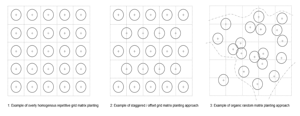
Randomised matrix planting has benefits and has its place, but over very large areas, it can create complicated planting arrangements which are tricky to maintain with grasslands and surrounding planting having to be predominantly maintained by hand (which is costly and time-consuming), rather than machinery. Randomised matrix planting is best implemented to woodland edge areas, or across targeted smaller planting plots to create open and organic treatments.
Tree planting typologies need to vary to ensure the best fit for the site, provide a variety of habitats and to avoid homogonous tree planting. Species variation informed by local context, with variety in densities for woodland edge, woodland core, woodland screening will create a variety of habitats which in turn will attract varied flora and fauna. The inclusion of features such as rides and glades, i.e. breaks in woodland coverage (see Figure 15), will offer contrasting sunnier habitats to the denser core woodland areas and offer variations in habitat.

Factoring in management and creating an environment for plants to thrive
Successful habitats are dependent on on-going management. At HS2 a management plan is produced at the design stage, which should consider access to facilitate long-term management. General grass cutting, weed suppression, and thinning are all critical to reduce competition, and create the best possible environment for plants to thrive.
In advance of tree planting, early ground preparation and the cultivation of soils can assist in establishing a strong grass sward (an area covered with grass) which will also help in general weed suppression and in creating good soil conditions. The early habitat creation sites were typically planted into existing agricultural ground which were subject to drying in drought conditions. The main works planting will typically be in ‘made-ground’ profiles, where the process of soil cultivation and grass sward establishment will be key.

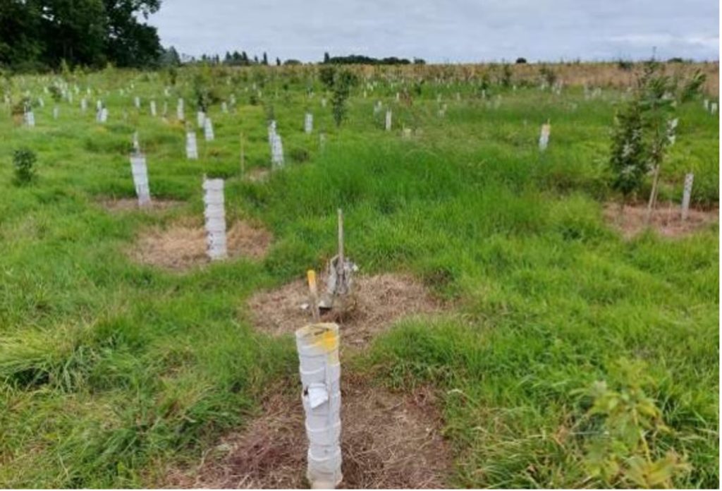
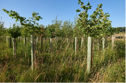
Absence or breaks in maintenance (which can occur for example when there is a change in supply chain), can lead to competition and over shading which can result in tree failures. Smaller tree stock is particularly susceptible to this risk and can easily become swamped or suffocated by grass. Regular strimming around trees has generally proved very beneficial (see Figure 16), although it was often found that tree guards and stakes were damaged by over enthusiastic strimming to the detriment of the trees they were trying to protect. Specifying the reduction of grass around trees by other means has also been successful, with the use of wood chippings (bark mulch) not only supressing grass/weed growth but aiding insulation and improving water retention. Mulch mats have been used on early habitat creation sites as an alternative to control weeds, but these can be expensive and difficult to install and remove. Herbicide application (spraying) is another traditional weed suppression method (see Figure 17), but this might not always fit with the ecological objectives of the site. Tree guards can provide protection from the application of herbicides when supressing weeds around the base of trees, as well as offering a sheltered micro-climate, general weathering and maintenance activity protection, and the obvious protection from animal predation.
Protection from grazing
The UK deer population is currently at its highest level for 1,000 years and is threatening the establishment of new woodlands and the diversity and structure of existing woodland. Experience across the early habitat creation sites has shown that although tree guards can successfully protect individual trees should they be of an appropriate height (see Figure 18). The absence of perimeter stock-proof fencing leaves shrub and tree planting prone to heavy predation. Tree guards at 1.2 m high will typically protect against rabbits, hares, muntjac and Chinese water deer, but they will not protect against large species like roe deer, fallow deer, sika and red deer, all of which are present along the HS2 route. These species will need tree protection ranging from 1.5 m to 1.8 m high (the latter for sika and red deer).
Protection from animal predation should be provided based on the perceived likelihood of damage from grazing versus the impacts the potential damage may pose to the habitat objectives for the site. It may be more economic and/or sustainable not to provide high levels of tree protection and replace or accept low levels of plant loss dependant on the volume of trees in question, the known predation risk level, and/or the site access and ownership arrangements.
In some areas, the use of fencing may be the best approach noting the balance in costs of tree guards vs fencing. However, beyond the capital cost, consideration also needs to be given to the ongoing maintenance and replacement costs, consenting requirements and the costs for removal and disposal.
A review of the animal predation risk (particularly deer risk) should be undertaken at the outset of the design stage, to inform the protection method and the associated height of any tree guards and/or stock proof fencing. HS2 are using the results of grazing pressure on the early habitat creation sites to inform protection approaches for the main works planting.
Conclusion and Recommendations
This document outlines good practice and lessons learned during the design and creation of ponds and woodland in over 100 areas of habitat for wildlife mitigation and compensation on the HS2 project.
In terms of successes, maintenance inspections and monitoring has shown that the early habitat creation sites are being used by translocated species and species which have colonised the sites naturally. These sites are already contributing to the HS2 Green Corridor. The lessons learned from these early habitat creation sites will be applied to future habitat creation work. Most of the habitat creation on HS2 will be completed at the end of the main construction works.
Some of the key outcomes and recommendations to promote success include:
- Integrated teams of the right specialists, inputting from early in the design phase,
- Ponds designed in the right place with the correct sizing to ensure they establish and hold water,
- Allow sufficient procurement time for tree planting and implement at the correct time of year within the predefined growing season and within a window of preferable weather and ground conditions,
- All ground preparation should be undertaken in advance of tree planting with establishment of a grass sward where possible,
- Trees should be planted with appropriate protection (fencing and/or guards),
- Mulching and watering should be applied as required, but watering can be mitigated as practical by planting small juvenile stock and using best practice workmanship, and
- Planting implementation programmes should de-risk potential construction delays, and give due consideration to lead times, facilitate grass establishment, and target achievable planting seasons.
These principles will help future HS2 work and the wider industry in more efficient approaches to habitat creation and will be of interest to people involved in environmental design, planning, and implementation.
Acknowledgements
Contributors: David Thompson, HS2 Senior Environment Manager (and formally Landscape Lead) and James Agg, former HS2 Groundwater and WFD Specialist.
References
[1] HS2 Phase One environmental statement: documents. Department of Transport and HS2 Ltd, November 2013. Available at:HS2 Phase One environmental statement: documents – GOV.UK (www.gov.uk)
[2] Licence WML-OR25 Issued to: HS2 Ltd and to persons authorised by HS2 Ltd under this licence Great Crested Newt – HS2, Phase 1 London to West Midlands. Available at: Natural England: Wildlife Licences and HS2 – HS2
[3] HS2 Act – High Speed Rail (London – West Midlands) Act 2017. Available at: High Speed Rail (London – West Midlands) Act 2017 (legislation.gov.uk). Accessed 14 April 2024
[4] Water resources licences: when and how you are charged. Environment Agency, July 2023 Available at: Water resources licences: when and how you are charged – GOV.UK (www.gov.uk) . Accessed 14 April 2024
[5] Great crested newt mitigation guidelines (NEWT1): Natural England 2014. Available at: [ARCHIVED CONTENT] Great crested newt mitigation guidelines – NEWT1 (nationalarchives.gov.uk). Accessed 14 April 2024
[6] Estimation of Open Water Evaporation. Environment Agency, October 2001. Available at: https://assets.publishing.service.gov.uk/media/5a74b4bae5274a3f93b4823a/sw6-043-hb-e-e.pdf . Accessed 14 April 2024
[7] Rainfall Data. National River Flow Archive. Available at: https://nrfa.ceh.ac.uk/rainfall-data . Accessed 14 April 2024
[8] Light Detection and Ranging -LiDAR is a technology that uses laser beams to measure distances and create 3D maps of the Earth’s surface or objects. National LIDAR Programme, Environment Agency March 2024. Available at: National LIDAR Programme – data.gov.uk . Accessed 14 April 2024
[9] Online Map viewer, National Library of Scotland. Available at: https://maps.nls.uk/geo/explore/#zoom=5.0&lat=56.00000&lon=-4.00000&layers=1&b=1 . Accessed 14 April 2024
[10] BRE 365 – Available online. BRE documents are behind a paywall, but other summary documents are freely available
[11] British Geological Survey Maps: Available at: https://mapapps2.bgs.ac.uk/geoindex/home.html?layer=BGSBoreholes&_ga=2.81286622.815477055.1668686534-1210126151.1668686534
[12] UK Soil Data. Available at: UK Soil Observatory (bgs.ac.uk) . Accessed 14 April 2024
[13] Singer, D., Hondong, H., Dietz. M. (2021) Habitat use of Bechstein’s Bat (Myotis bechsteinii) and woodpeckers reveals the importance of old-growth features in European beech forests. Forest Ecology and Management, Volume 498, 15 October 2021.