HS2 Area North Route Map Tool
The Route Map was developed to provide an oversight of the entire works of the Main Works Civils Contract (MWCC) Area North with detailed summaries of each sublot, enabling stakeholders to better understand the works across the BBV Integrated Project Team (IPT).
Information Management, Sublot Directors and the Communication team worked together to develop the Map which was continually improved by responding to feedback and providing additional functionality. The document has become a valuable tool for both inductions and as a reference document. Being able to quickly identify key contacts for each site helped the teams stay connected, which on a 90km long route can otherwise be challenging. Information provided enables better knowledge share between teams and this is critical when sharing Health and Safety related lessons.
This paper will be of interest to any project working across multiple teams and sites to ensure clarity and understanding of all requirements and to maintain health and safety standards.
Background and industry context
The BBV Integrated Project Team (IPT) are delivering the Main Works Civils Contract (MWCC) for the northern section (AKA Area North) of High Speed Two (HS2) Phase One which includes Long Itchington Wood Green Tunnel to Delta Junction and Birmingham Spur and the Delta Junction to the West Coast Main Line (WCML) tie-in.
Due to the length and complexity of the Area North route, compared to that of previous projects encountered by the companies that make up the BBV integrated project team, it was accepted that a more detailed tool would be needed to support the context of HS2’s work. With nine locations, each a major infrastructure project in their own right, the contact and address information detail needed would go beyond the site contact sheets previously relied on for other projects.
Approach
With over 90km of route and sites setting up at pace during a pandemic, the need to provide IPT Area North with access to key information of their route, beyond a contact list by job roles or locations, soon became a key tool for the Communications team to develop. The brief was simple: provide a document that would enable delivery, promote safer journeys between sites, (at a time when journeys were restricted to key workers only), and promote efficient communication between colleagues.
The input of the Information Management team, Sublot Directors and the Communications team concluded that the first phase of the Route Map document should:
- Contain an overview for each Sublot highlighting the major works and challenges for the works on site and, where appropriate, details of key stakeholders
- Contain key features and assets for each Sublot
- Include the contact information for Health & Safety Managers, and both BBV and HS2 Site Directors to further promote the desired IPT ways of working
- Be a tool that is accessible to all IPT Colleagues (overcoming issues of accessing platforms outside of a colleague’s parent company parameters)
Whilst creating the document, there was feedback from contributors of the issue with some of the postcodes for the main locations. Often the postcodes would cover such a broad area resulting in delivery vehicles or visitors driving on to private driveways or farms. The inclusion of What3Words, provided a safer way of getting people directly to site. The additional benefit to using this location tool is that it is approved and used by the emergency services teams and would increase the opportunity for a quicker response should a colleague need medical attention whilst on site.
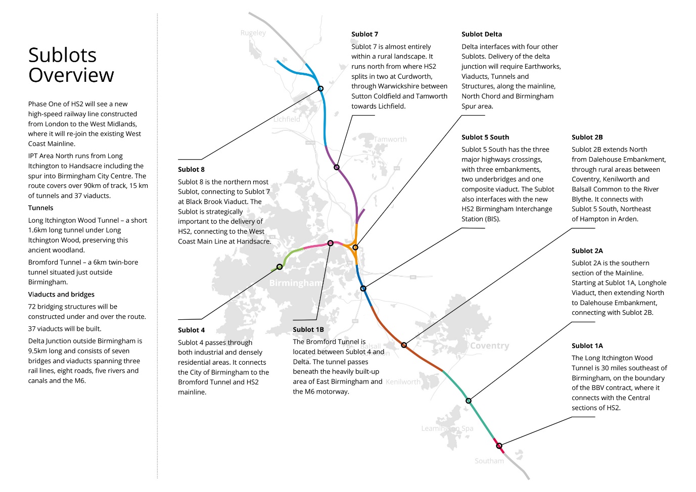
With teams ‘locked down’ to their specific Sublots in line with COVID-19 requirements, it soon became apparent that an image showing the geographic extent of the route, highlighting the number of / location of the Sublots and the significant urban conurbations that the route ran through would help colleagues, Client, and Stakeholders to understand the wider route in the absence of being able to visit the sites.
Outcomes
The first edition of the Route Map was launched in December 2021 via an all hands call for all IPT colleagues. Accessibility for all IPT Area North colleagues, regardless of their parent company, was key to its success and was achieved by hosting the document on the BBV SharePoint and giving all IPT colleagues (DJV, HS2, SB3 and Construction Family members) guest access.
Sign off of the original document had been challenging, with many revisions being made to contact details as the project progressed. The arduous work in ensuring the document contained the most up to date information was incredibly well received. The Communications team concluded that the Route Map should contain links to other important IPT documents such as Our Blueprint (which sets out the IPT values, guiding principles and ways of working – as well as an overview of each team) and Enabling our Sublot Delivery (which gives clear guidance on how all teams work together to support the successful delivery of the project) and the ability to give feedback directly to the Communications team via the team email address. Promoting the desired two-way communication between IPT teams.
Learnings and Recommendations
The Route Map was embraced and promoted by the Learning and Development team and became a key tool reviewed during both staff and supplier inductions.
The HS2 Media and parent company communication teams welcomed the Route Map as an important crisis communication tool which could put them in touch with key site colleagues if needed.
Readership of the key documents of Our Blueprint and Enabling our Sublot Delivery increased, and encouraged positive feedback, including suggestions for improvements for future editions.
A key lesson learnt was to engage with the Design team (for assets) and Personal Assistants and Facilities team members at each site (for contact and address information), rather than being reliant on input from the Sublot Director. Often, they were busy with delivery works and this, originally, contributed to a slow start to the document.
Learning Outcomes and Usage
Colleagues use the route map tool to source the relevant H&S representative to oversee any visits, filming or events on-site. Their presence during filming and events has ensured that the H&S best practice is followed and that we really do keep safety at the heart of what we do.
Alongside this, the document helps guide colleagues, suppliers and visitors efficiently to site, giving accurate location information through What3Words. Precise location information helps reduce driving time and unnecessary mileage, reducing wasted time and carbon emissions.
The document has been enhanced with the latest iteration, itemising individual major structures with contact information for satellite compounds and the relevant H&S representative for that area.
Conclusion
Early in the process of setting up the IPT it was obvious that a more detailed, comprehensive route map was a fundamental requirement to ensure our colleagues go to the right place first time and safely.
Given the complexity of the line of route, its continual development and not least given the 169 construction starts due to take place in 2023, the detail provided in the route map has proved to be essential to those working on a project of this size and invaluable to those just starting out in their career journey with BBV.
Acknowledgements
The Route Map was designed and managed by the BBV Communications team with contributions from Site Directors for BBV and HS2, Health and Safety, Logistics and Facilities teams.