Innovative use of drone technology for Enabling Works surveys
Engineering surveys for the Area South enabling works on High Speed Two (HS2) were required to capture 3D data of sites for use in design and as-built surveys. There are inherent safety risks in traditional survey approaches such as working as height, works in confined spaces and hazardous environments. The latest engineering survey technology was used to reduce the amount of at-risk working hours.
This report highlights the engineering survey team’s development and implementation of the drone technology for surveys including pre-demolition and dilapidation surveys, and shaft inspections. The team worked with all different disciplines on site to utilise the latest innovative drone technology to provide better deliverables while increasing safety and cost and time savings.
This learning legacy will be of interest to future projects considering their approach to engineering surveys and budget planning.
Introduction
Area South of the Enabling Works Contract (EWC) is the southern section of High Speed Two (HS2) phase one, delivered by the Costain Skansja joint venture (CSjv). The works include demolition of buildings within the wider Euston area, utility diversions, environmental and ecological monitoring and a programme of historic environment and archaeological activities.
The main focus of the engineering survey team for the Area South EWC has been to survey and capture 3D data of sites, for use within design and as-built surveys.
A dedicated in-house team enabled all of the drone operations to be fully managed internally ensuring all of the surveys fulfilled a strict quality assessment and all flights met the legal requirements set out by the Civil Aviation Authority (CAA).
The sections below present examples of how drone technology has been used to reduce the amount of at-risk working hours in three key areas, describing what was done and the benefits that were achieved.
Pre-demolition survey
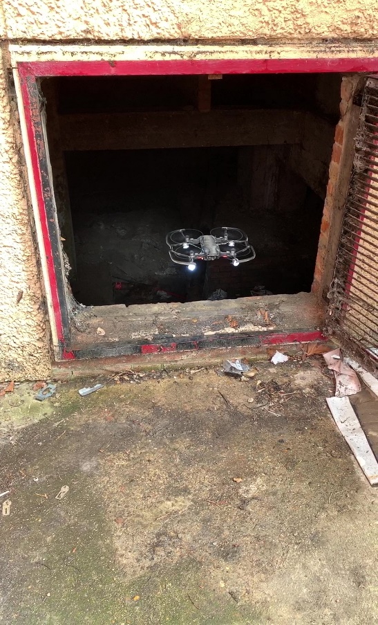
Pre-demolition surveys of a 20th century structure, including a basement with confined space access requirements, were undertaken using an unmanned aerial vehicle (DJI Mavic Air) with custom lights mounted. The engineering survey team deployed drones into basements to negate the need for people to enter a space where the presence of asbestos and overall occupational health risks were unknown and a high-risk working environment was anticipated.
A trained and competent engineering survey team were able generate video data to assess the presence, extent and location of asbestos.
Benefits:
- Zero confined space access – 16 person hours of confined space working avoided.
- Video data which can be checked and referenced off site during planning and RAMS creation.
- Generation of high-resolution visuals for use during training and start of shift/RAMS briefings.
- Interdisciplinary shared learning between Tier 1 contractor and subcontractor.
Dilapidation survey
A complete dilapidation survey was undertaken to identify structural issues, such as cracking and movement of non-designated railway assets, constructed in the 1880s as part of Euston Railway cutting. The team deployed 3 drones with 3 pilots across a 300m long, 6m tall asset in mass gathering data exercise to minimise impact on working railway and live construction site.
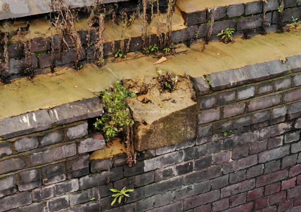
All necessary data was gathered within 1.5 hours, generating 5500 high resolution images which were then incorporated into a 3D model using photogrammetry.
Benefits:
- Reduced impact on construction programme.
- Zero working at height.
- Zero additional plant required.
- Zero additional carbon produced.
- Saved months of on-site work and planning, reducing costs by £10,000’s.
Shaft inspections
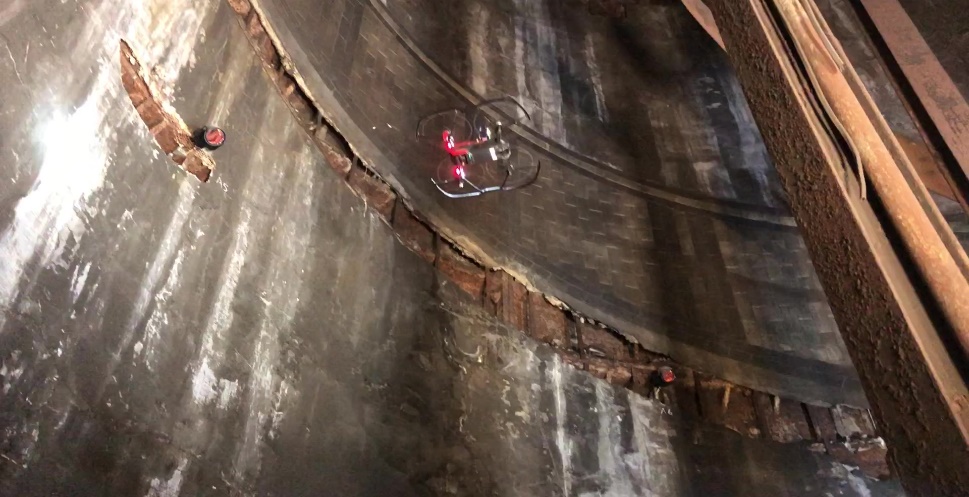
Drones were utilised during a shaft inspection in the historic London Underground Euston station – now a traction sub-station. The team deployed drones within the shaft to provide a full condition survey of the structure. This was in advance of design changes to incorporate new ventilation and connections to the replacement traction sub-station.
Operations consisted of a vertical flight from base of shaft to top of shaft capturing M&E, condition and access arrangements. Surveyors collected footage to capture key structural elements.
Flight testing and operations were completed in 4 x 20-minute flights by one drone surveyor.
Benefits:
- No procurement for scaffold or scaffold design.
- Zero temporary works inspections.
- Saved £10,000’s in costs and working hours.
- Zero working at height.
- Zero manual handling.
- Condition record generated to form part of Health and Safety file.
Lessons learned and successes
The engineering survey team have been able to provide leading edge survey capability for all of the sites and packages within the Area South EWC. Having experts in-house to instantly deliver this service has removed overhead costs and downtime, and even mitigating the need for additional operatives on site has helped reduce the site’s carbon footprint by reducing unnecessary travel.
Various uses of drone technology within confined space and hazardous environments greatly reduced the at-risk working hours for the project.
By starting the project with the right budget and the right people, the engineering survey team have been able to provide an industry leading drone survey capability while reducing costs and making the working environment safer.
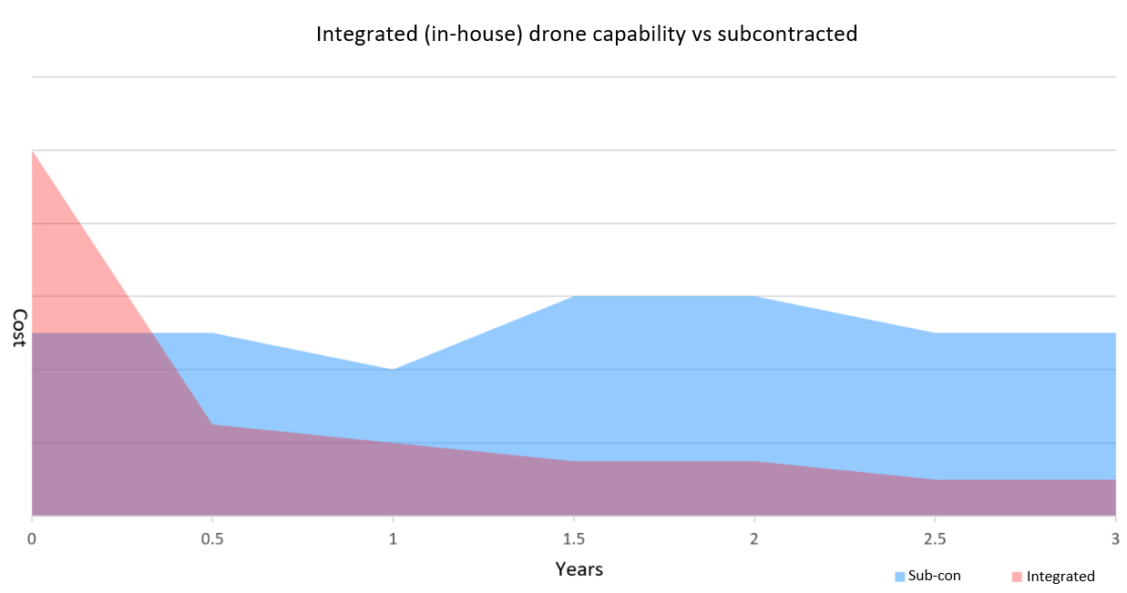
Drone technology has led to considerable cost savings compared to the industry standard approach. Generally, it becomes more expensive over time to continually rely on a subcontractor to deliver a survey service; and misunderstandings in scope or contract can lead to additional costs. Example of costs over 3 years for drone survey capability:
By starting the project with the right budget and the right people, the engineering survey team have been able to provide an industry leading survey capability, whilst reducing costs and making the working environment safer.
Recommendations for future projects
The initial cost of setting up the right engineering survey capability often deters sites from implementing the right technology and people at the start of a project.
The engineering survey team is a good example of getting the budget correct at the start and then relying on the expertise of your team to deliver a high standard of surveys.
Conclusion
Having an integrated approach enables the engineering survey team to respond to site requirements in hours instead of days. Having prior knowledge of the site and creating a relationship with the site managers and surrounding community ensures surveys, such as drone flights, can be quickly implemented in a safe and controlled manner.