Monitoring the quality of surface water during the HS2 Enabling Works, Area South
Many watercourses in London are historically culverted and built over. The main watercourses that needed to be monitored during the High Speed Two (HS2) Enabling Works Contract (EWC) were between West Ruislip and Newyears Green. To ensure water quality was not affected by construction works, a risk-based monitoring strategy was designed for the western watercourses that comprised 11 sampling points, monitored on a monthly basis over a period of 12 months. The monitoring was designed to provide HS2 and the Environment Agency (EA) with a high degree of confidence in the data produced. As such, the design delivered sampling in line with industry best practice for sampling methodology and quality assurance. The methodology has subsequently been implemented by the follow-on Main Works contractor and will be of use to other projects.
Background and industry context
The focus of this paper is the Enabling Works Contract (EWC) on the southern section of High Speed Two (HS2) phase one, which includes demolition, surveys, utilities diversions, vegetation clearance, archaeological excavations, exhumations/reburials and tree planting delivered by the Costain Skanska joint venture (CSjv).
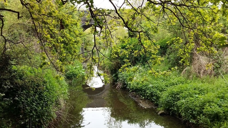
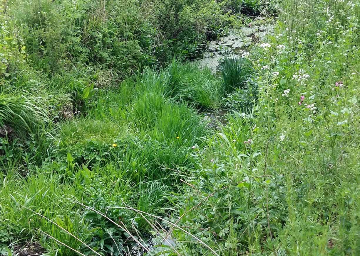
Through the southern section of the project, a large part of the HS2 route through London is by tunnel from the outskirts of Euston to the tunnel portal in West Ruislip. In addition, many watercourses in London have historically been culverted and built over. Therefore, the main watercourses that needed to be monitored during the enabling works were in the west of Sector S2 (West Ruislip to Newyears Green). These watercourses included the Ickenham Stream (a tributary of the Yeading Brook flowing from West Ruislip Golf Course), the River Pinn (Figure 1; a low baseflow watercourse channelling rainfall running off the London Clay/Lambeth Group geology and prone to seasonal flooding) and the Newyears Green Bourne (Figure 2; a stream seasonally fed with Chalk groundwater that is prone to winter flooding because its headwaters receive ‘flashy’ runoff from the London Clay to the north).
As outlined above, the EWC southern section covers the route from London’s Euston Station to the edge of the Colne Valley to the west of London. As documented within the EWC Water Framework Directive Assessment Update [1], the enabling works activities represented a relatively low risk to surface water quality along the route, but did include localised construction work and excavation that required mitigation and monitoring where the HS2 route is above ground in the far west of the southern section.
Design and implementation of the monitoring
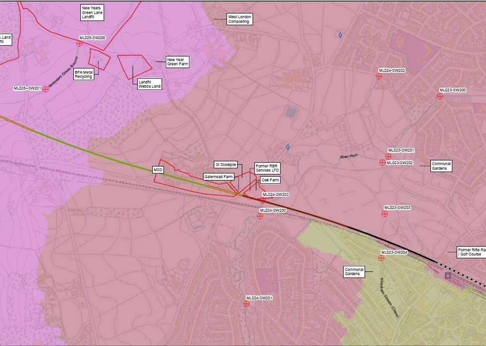
A monitoring strategy was designed for the watercourses in the western part of the southern section that comprised 11 sampling points (Figure 3), which were monitored on a monthly basis over a period of 12 months to detect elevated concentrations of construction-related chemical parameters from enabling works activities. A risk-based suite of chemical parameters related to common pressures and impacts from construction activities was implemented, for example pH impacts from cement/concrete leachate, Total Suspended Solids to detect inputs of silty water, oil/hydrocarbons and heavy metals.
The aim was to design the monitoring in a way that provided HS2 and the EA with a high degree of confidence in the data produced. Care needs to be taken when designing water sampling to be mindful of laboratory standard operating practices, which do not always align with best practice when it comes to recommended sampling methodologies. This can lead to concentrations of parameters like ammonium and dissolved metals being either underestimated or overestimated; an outcome that could lead to a greater number of exceedances of the Environmental Quality Standards (EQS) (a measure of potential pollution) not being identified. If this were to happen, an inaccurate and low quality EWC dataset would be generated.
The British Standard for Water Quality – Sampling [2] requires that water samples are preserved in the field in order that concentrations of redox sensitive or pH-sensitive chemical parameters do not alter during transit to the laboratory via volatilisation, oxidation, adsorption or precipitation in the bottle [2, 3]. For example, for ammonium (indicative of sewage or landfill leachate), the sample bottle for this parameter will contain a small volume of sulphuric acid to hold concentrations of ammonium in solution to prevent it transforming into ammonia gas. For dissolved metals (including aluminium, chromium and copper that can leach from concrete), water samples must be filtered at the sampling point and preserved in a bottle containing a small amount of nitric acid to prevent dissolved metals adsorbing to the inside of the sample bottle.
Another important aspect of ensuring that there is a high degree of confidence in the final laboratory concentrations report is undertaking a thorough quality control of the data to check for errors that could affect the interpretation of water quality. Physico-chemical measurements (e.g. pH, dissolved oxygen, etc.) recorded in the field need to be checked as soon as possible against laboratory data to pick up any errors. If discrepancies are identified, repeat analysis of the sample should occur before the sample exceeds its laboratory holding time (effectively its shelf life). The simplest way of picking up errors is by comparing samples against results of previous samples at the same monitoring point or other sampling points in the area. Another way of detecting issues is to include quality assurance samples in long-term sampling programmes. Therefore, the design of the monitoring for the southern section included various measures for quality control including monthly contractor self-assurance of the data against a number of pre-defined checks (e.g. ionic balance, agreement between field versus laboratory measurements, agreement with previous samples) and provision of 10% of samples as quality assurance samples to check for sample contamination (e.g. field blanks) and reproducibility of the data (e.g. split duplicate samples).
Under the contract between CSjv and the sampling contractor, the contractor was required to self-assure their sampling; quality assurance samples had to be checked and the data quality controlled each month, presented to the Water Specialist in a concise monthly report and teleconference. This approach was an integral part of providing HS2 with confidence that the data produced were of the best possible standard. The monthly reports are referenced within the Interpretive Report [4] for the monitoring.
Outcomes and learning
The results of the monitoring highlighted water quality in these watercourses that exceeded the EQSs. However, rather than the ‘exceedances’ being for construction parameters like pH, suspended solids and fuel hydrocarbons, the results exceeded the EQS for dissolved oxygen, ammonium, phosphate, nitrates and trivalent chromium. These are parameters more commonly associated with impacts from either landfill, agricultural or urban diffuse pollution (for example sewage), with signs of slight historical industrial or railway contamination. This indicated no water quality impact from the EWC in the southern section, but instead defined with accuracy the pre-construction baseline for water quality in the Pinn and Newyears Green Bourne (the Ickenham Stream was frequently too dry to sample), prior to Main Works Civils Contract (MWCC) engineering and construction.
EQS exceedances occurred in both the River Pinn and Newyears Green Bourne, with the highest concentrations having occurred in the Newyears Green Bourne. Closer examination of the pollution pressures that already exist in the catchment of these watercourses shows that impacts can be attributed to a number of possible sources including nearby historic landfills, former pharmaceutical uses, a former rifle range, the embankment of the Chiltern Main Line railway, allotments, consented discharges to ground and highway drainage entering watercourses (Figure 3). However, the interpretive report concluded that the greatest effects observed are likely to result from the Newyears Green Lane Landfill, (beneath which the Newyears Green Bourne flows through a culvert) and diffuse urban pollution (from leaking water mains and sewerage pipework) in the River Pinn catchment.
Upon completion of the monitoring and reporting, the EWC data were provided to MWCC to contribute to their baseline surface water quality data set. The approach with regards to best practice sample preparation methods (which are not fully detailed in the HS2 Technical Standard for water monitoring [5] but are outlined in the CSjv Surface Water Monitoring Plan [6] and detailed in the British Standard [2]) and the need for careful quality control and assurance was presented to both HS2 and the MWCC. Following this work, the MWCC have changed the laboratory delivering the analysis of their surface water samples to one that is compliant with the British Standard [2]. In addition, they have also introduced field blanks and duplicates into their monitoring in order to assure the quality of the data to HS2.
Recommendations
The EWC monitoring was designed to avoid issues of poor sample preparation and the key objective was to achieve data of a high quality for HS2. The potential pitfalls of receiving third party data that has not been collected to this standard are:
- Receiving inaccurate water quality data that could suggest pollution is occurring when the issue is actually data quality.
- Receiving unchecked data containing errors. Whether for surface water or groundwater sampling, the importance of carefully designing the sampling to maximise the quality of the sampling cannot be overstated.
Another essential point is the importance of thoroughly checking data provided by a sampling contractor (too often this is not done) as soon as it is received, in case any checks of potential errors are needed with the laboratory or even the need for repeat analysis before the sample holding time expires and it is too late. Therefore, it is recommended that the design of HS2 water sampling should be carefully made to be compliant with the requirements of the British Standard [2]. In addition, HS2 water sampling in other parts of the HS2 route should include quality assurance samples and thorough, recorded quality control checks to check for sample contamination or analysis errors.
Conclusion
This approach and the resulting accuracy not only satisfied the requirements of the HS2 Technical Standard [5] and the up-to-date British Standards (for water sample preparation and preservation [2]), but also allowed CSjv to assure HS2 with confidence that any elevated or non-compliant chemical concentrations detected during the EWC would demonstrate a real environmental impact.
The benefit of this work has been twofold: firstly, to provide HS2 and the EA with strong evidence that any pollution of the surface water monitored during the EWC is non-HS2 (unrelated to construction); and secondly, that it provides a valuable, high quality baseline dataset for the MWCC to help define baseline water quality against which to monitor any effects of construction and discharge activities. The recommendations of this work with respect to sampling methodology have also now been implemented by the Route MWCC in the southern section.
Acknowledgements
The author would like to thank AECOM (Croydon office), the contractor who delivered the monthly monitoring work, delivered the monitoring design described and wrote the interpretive water quality baseline report [4] at the end of the monitoring.
The author would also like to thank the CSjv Monitoring and Instrumentation team: Dean Bain, Djamal Renard, Ramraj Shetti, Kyriakos Papaioannou and Libby Lindsay, who were essential in setting up the contract and dealing with the commercial aspects of the work.
References
[1] 1EW02 Enabling Works – Area South: Water Framework Directive Assessment Update, 1EW02-CSJ-EV-REP-S000-000097.
[2] BSI, 2018. British Standard for Water quality – Sampling, Part 3: Preservation and handling of water samples. BS EN ISO 5667-3:2018.
[3] Trick, J.K., Stuart, M. and Reeder, S., 2018. Contaminated Groundwater Sampling and Quality Control of Water Analyses, Environmental Geochemistry: Site Characterization, Data Analysis and Case Histories (pp.25-45). DOI:10.1016/B978-0-444-63763-5.00004-5.
[4] 1EW02 Enabling Works – Area South: Surface Water Quality Monitoring Interpretative Report, 1EW02-CSJ-EV-REPS002-000159.
[5] HS2, 2019. Water Resources and Flood Risk Monitoring Technical Standard. HS2-HS2-EV-STD-000-000029.
[6] 1EW02 Enabling Works – Area South: Surface Water Monitoring Plan. 1EW02-CSJ-EV-PLN-S000-000078.