Resilient river landscapes – River Cole realignment: mitigating climate change through landscape design
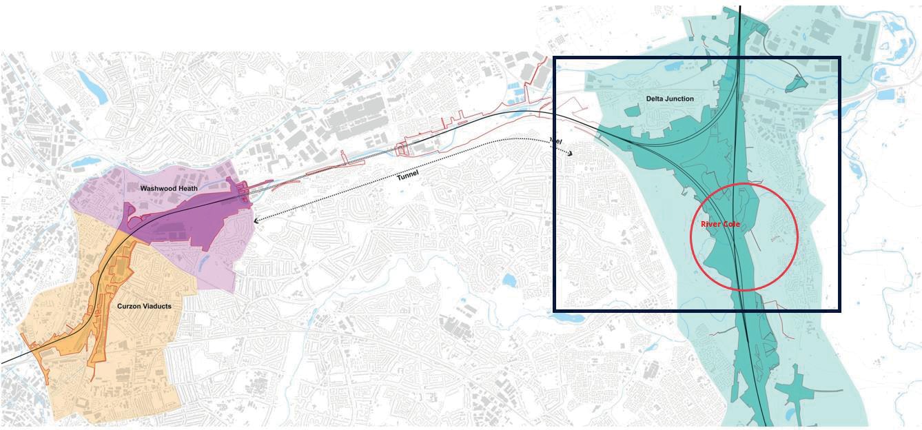
The River Cole is located within the southernmost section of the Delta Junction, a triangular section of High Speed Two (HS2) Phase One, where the route curves west towards Birmingham and runs north towards Crewe. In order to accommodate the HS2 route the River Cole will be realigned.
Referencing the HS2 key design principles of Conserve, Enhance, Restore and Transform this paper considers the effectiveness of the project specific design guidance and industry-wide best practice in delivering the River Cole realignment, whilst maintaining and ultimately improving a holistic river environment: Conservation of existing elements within the landscape means preserving the environment and landscape character including the local heritage site at Coleshill Manor; Landscape Enhancement will require integrating the displaced river into the existing landscape through designing new bank shapes, contouring and meanders to create a diverse natural river channel over time; Restoring the landscape during and after the construction phase, then emphasising its unique character, is key. The realignment of the river will allow new shallows, riffles and pools to be created. Reconnecting footpaths along the river will be an added benefit for the local community.
Transformation of the river landscape requires the development of a robust and species rich wetland ecology around the river. The design process for the displaced river is driven by habitat creation, improved biodiversity and landscape enhancement realised though the collaboration of several disciplines aimed at climate resilience and a richer tapestry of life through biodiversity.
This paper concludes how these principles have been implemented in the design and whether the results can be deemed best practice for similar projects on river restoration and riparian enhancement.
- Written by
-
Michael Beswick (SYSTRA/DJV)

- Resource type
- Resource type: Good Practice Document
- Intended audience
- Consultants
Introduction
The Main Works Civils Contract (MWCC) for the northern section of High Speed Two (HS2) Phase One includes Long Itchington Wood Green Tunnel to Delta Junction and Birmingham Spur and the Delta Junction to the West Coast Main Line (WCML) tie-in, being delivered by the Balfour Beatty VINCI (BBV) Integrated Project Team (IPT). Systra is part of the Mott Macdonald Design Joint Venture (DJV) within the Balfour Beatty Vinci (BBV) IPT.
The High Speed Rail Act (2017) grants deemed planning permission for HS2 Phase One of the route, however a number of detailed design and construction elements are subject to further approval. Schedule 17 to the Act puts in place a process for the approval of certain matters relating to the design and construction of the railway. It requires that the nominated undertaker (HS2 Ltd) seeks approval for matters of construction and design from the appropriate planning authority.
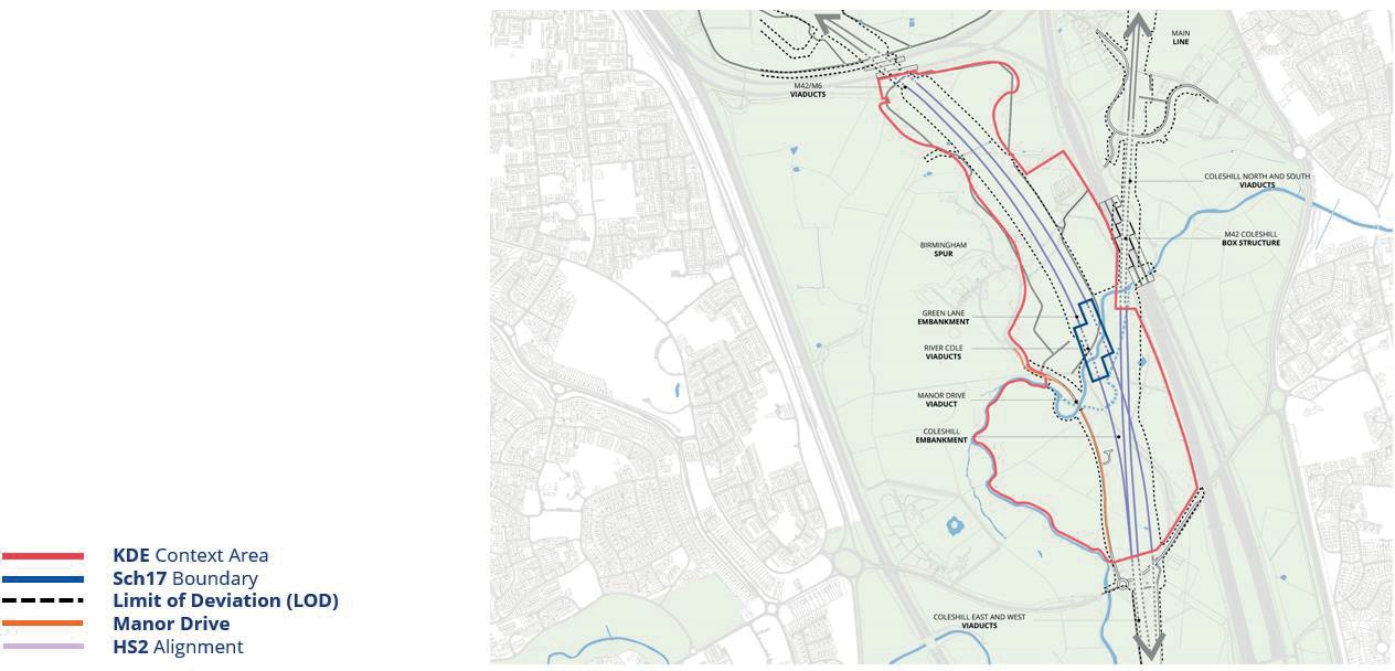
The infrastructure and enhancement associated with the River Cole, including two large viaducts, embankments and the displacement of the river, combine to create one of the most significant developments along the HS2 Phase One route. As such, it is considered to be a Key Design Element (KDE) that requires the additional scrutiny of the Independent Design Panel (IDP).
Therefore, the DJV scope includes extensive public and stakeholder engagement and the preparation of a series of detailed plans, schedules and a Design and Access Statement (DAS) prepared to support the submission of Schedule 17 requests for approval to North Warwickshire Borough Council (NWBC).
HS2 Green Corridor and the River Cole
HS2 are committed to minimising and compensating the environmental impacts of its proposed infrastructure, including the minimising the loss of habitat from constructing an operating the railway and, where possible, are committed to enhancing landscapes affected by the route.
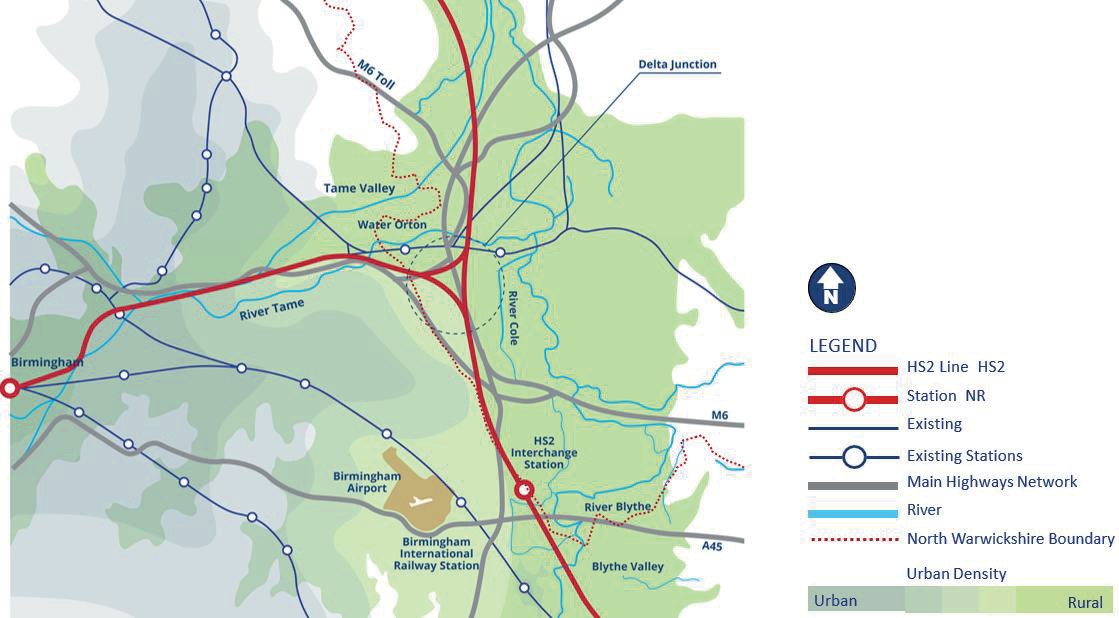
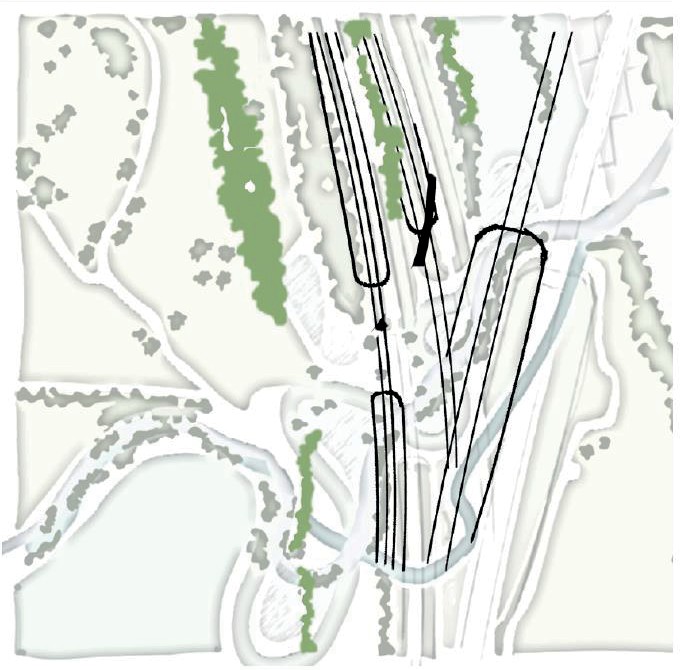
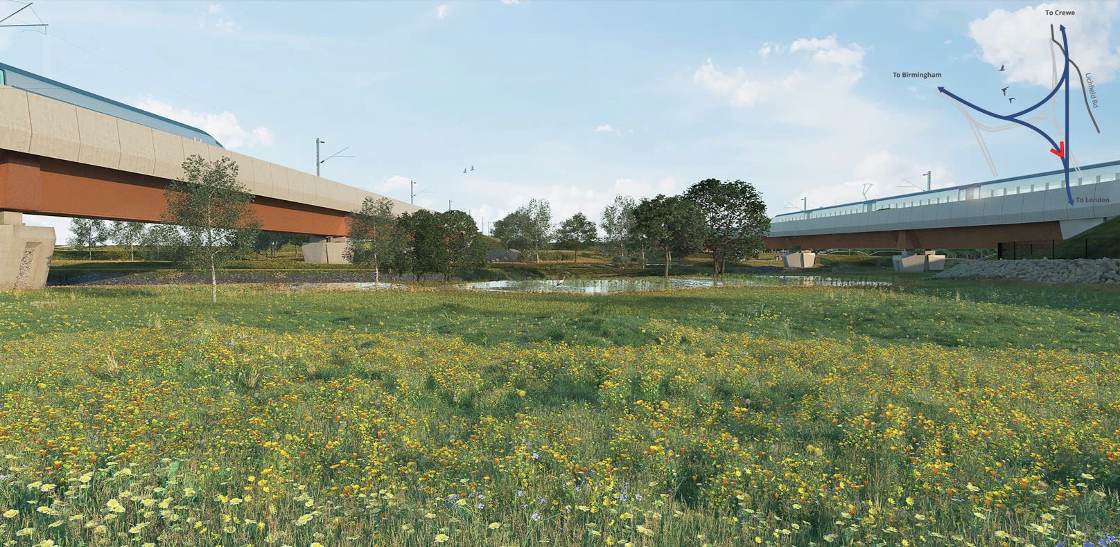
HS2’s Green Corridor “is the largest single environmental project in the UK. We will leave behind more than 33 square kilometres of new woodland, wildlife and river habitats alongside the line from the West Midlands to London, the equivalent of 23 new Hyde Parks lining the spine of the country”1 Along this Green Corridor lie a number of important Sites, not least the River Cole and its floodplain. The River Cole is located within the southernmost section of the Delta Junction, within North Warwickshire Borough Council. The Delta Junction is a triangular section of railway, covering a distance of approximately 4.6km, where the HS2 route divides, curving westward to Birmingham and running northward to Crewe. The eastern section of the Main Line runs north and crosses the River Cole via the Coleshill viaduct with the western part, the Birmingham Spur, crossing the River Cole via a pair of single-track viaducts (the East and West Viaducts).
The proposed East and West Viaducts are each 158m long and include 4 spans. The Viaducts are large, engineered structures of concrete and steel intersecting the landscape, inclusive of the River Cole and its floodplain. Despite the railway being raised above most of this landscape on viaduct a significant amount of work is involved to ensure these structures are not only intersecting the landscape but are integrated into the landscape fabric. This landscape integration includes a number of elements, not least the displacement of the River Cole itself.
This paper will seek to dissect the HS2 design principles, governing the way in which DJV/BBV design landscapes around HS2 and vice versa, with a particular focus on the displacement of the River Cole and HS2 as a catalyst for green recovery and climate resilience, to determine if these methods are indeed best practice and easily translated to good design beyond HS2.
The River Cole sits within Arden National Character Area (NCA) 97, as defined by Natural England. The key landscape characteristics of this area are as follows:
- Well-wooded farmland landscape with rolling landform.
- Mature oaks, mostly found within hedgerows, together with ancient woodlands and plantation woodlands that often date from the time of enclosure. Woodlands include historic coppice bounded by woodlands.
- Narrow, meandering clay river valleys with long river meadows; the River Cole is a good example of this.
- Numerous areas of former wood-pasture with large, old, oak trees often associated with isolated remnants of more extensive heathlands. Village greens/commons have a strong association with remnant lowland heath. Fragmented heathland persists on poorer soils in central and northern areas.
- Diverse field patterns, ranging from well hedged, irregular fields and small woodlands that contrast with larger semi regular fields on former deer park estates, such as Coleshill Manor.
- Complex and contrasting settlement pattern with some densely populated areas where traditional settlements have amalgamated and some settlements that remain distinct and relatively well dispersed, the Gilson Hamlet is a good example of this.
- North-eastern industrial area based around former Warwickshire coalfield, with distinctive colliery settlements. The north-western area is dominated by urban development and associated urban edge landscapes such as managed green space – allotments, gardens, parks and public open spaces; playing fields, churchyards, cemeteries and institutional grounds (schools, hospitals).
- Transport infrastructure, the M42, and M6 are major transport corridors that sit within the landscape of this NCA.2
Within Volumes 2 and 5 of the HS2 Phase One Environmental Statement, relating to Coleshill Junction, CFA 19 “Chapter 9 Landscape and Visual Assessment”3, the Landscape Character Assessments (LCAs) within the area have been determined with reference to the Warwickshire Landscape Guidelines in the North Warwickshire Landscape Character Assessment (NWLCA)4 and the Warwickshire, Coventry and Solihull Green Infrastructure Strategy5.
The LCA around River Cole were identified as follows:
- Cole Valley LCA; and
- Coleshill and Cole End Settlement.
Cole Valley LCA has been derived from the NWLCA and falls partially within the Curdworth to Middleton area (CFA20);
- The landform of this LCA is defined by a broad valley with gently undulating terrain. The former historic parkland landscape has been fragmented by development, such as the
Lakeside Industrial Park on Marsh Lane, the major transport routes of the M6, M6 Toll and M42, and infrastructure such as National Grid overhead power lines and rail lines.
- The north of the LCA retains a rural character, comprising predominantly arable fields bounded by sparse but trimmed hedgerows and less development, including Coleshill Manor Office Campus, a number of residences and Coleshill Manor Farm.
- The narrow River Cole meanders across the LCA with mature trees along sections of its banks. The Belt, The Catmore, the Duck Decoy and Woodlands Cemetery are small belts or blocks, of mainly deciduous woodland in the parkland landscape around the Coleshill Manor Office Campus. These woodlands and the hedgerows are relatively well maintained and in a fair condition.
- The LCA is designated as green belt.
Coleshill and Cole End Settlement LCA is defined as:
- This LCA is located to the east of the study area and includes the villages of Coleshill and Cole End. These settlements are only narrowly separated by the River Cole which passes under the B4117 Lichfield Road and the A446 Stonebridge Road, the main routes connecting these settlements.
- Coleshill is situated across rising landform, from the river (approximately 75m Above Ordnance Datum (AOD)) westwards, to a ridge line at approximately 100m AOD. The land use is predominantly high density residential, with terraced and semi-detached two storey houses, schools, and shops.
- Two conservation areas cover central Coleshill, characterised by the narrow street layout and distinctive architecture. The main area of open space within Coleshill is the Coleshill Memorial Park Recreation Ground.
- The main vegetation patterns are street trees, garden planting and vegetation bordering the A446 Stonebridge Road. Cole End is of a similar residential character to Coleshill. This smaller settlement is situated across low lying, flat terrain between the River Cole, the A446 Lichfield Road and the Hams Hall industrial estates. There are few Public Rights of Way (PRoW) crossing the LCA.
The land adjacent to the River Cole has been identified as a ‘HS2 Heritage Hotspot’ displaying a rich history dating from pre-Roman up to the middle of the last century. From the Angles, a Germanic people who settled post-Roman Britain and used the rivers as navigable routes, entering these shores via the Humber estuary, colonising and eventually establishing the Kingdom of Mercia, through to modern history with the Edwardians tending to use the meandering rivers for boating and recreation and their more functional usage during and post WWII.
HS2 Design principles and the River Cole
The HS2 Design Vision6 was developed as a means to embrace HS2 and provide a suitable platform to achieve it. The core principles at the heart of the vision are People, Place and Time. The DJV set out to understand how people have used this landscape both historically and contemporarily, through extensive community engagement and research. Reflecting this research in a design which responds positively for the future as well as the present.
Understanding local requirements, landscape context and opportunities for benefits socially, economically, and environmentally.
DJV worked hard to understand the historic context of this landscape, the layers of history involved, and to develop a new layer for the 21st Century which responds to these characteristics based on the existing sense of place. This focussed on the sensitive integration of HS2 into the local landscape through conservation, restoration, enhancement, and transformation.
The design team endeavoured to design the landscape to respond to the changing nature of a water course over time so that it matures into a more naturalistic river channel surrounded by an extension to the Coleshill Manor parkland landscape. An adaptable riparian landscape, resilient to the impending impacts of climate change with HS2 as the catalyst.
The 3 core principles can be subdivided further into 4 key elements Conserve, Enhance, Restore and transform. HS2 suggest that these elements are imperative when designing landscapes around the HS2 alignment.
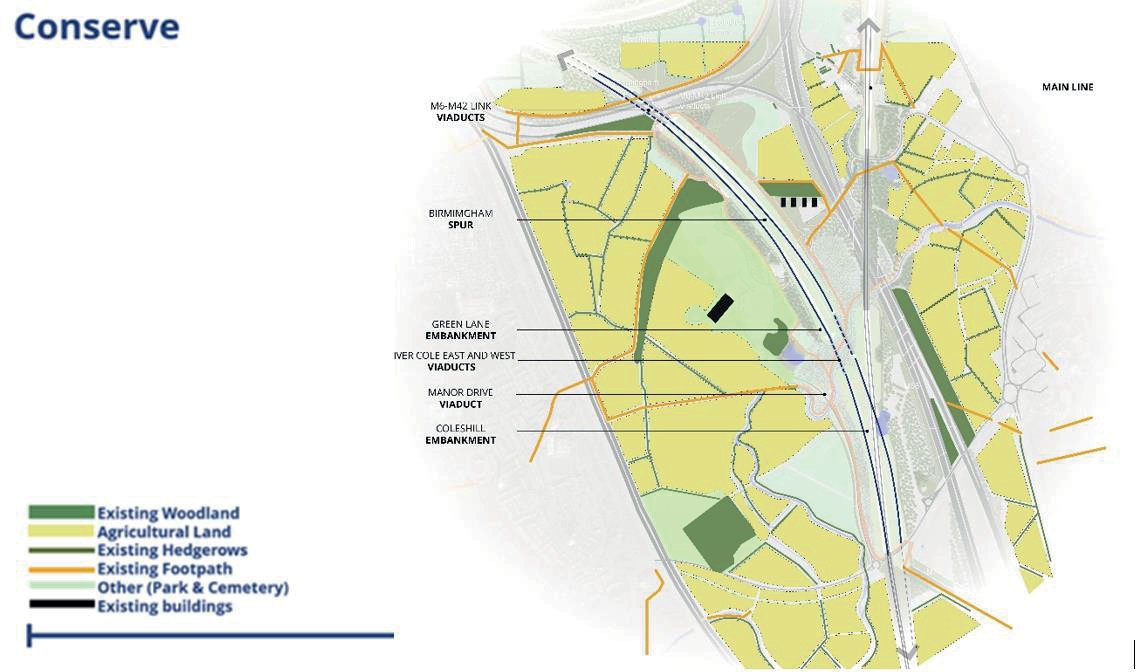
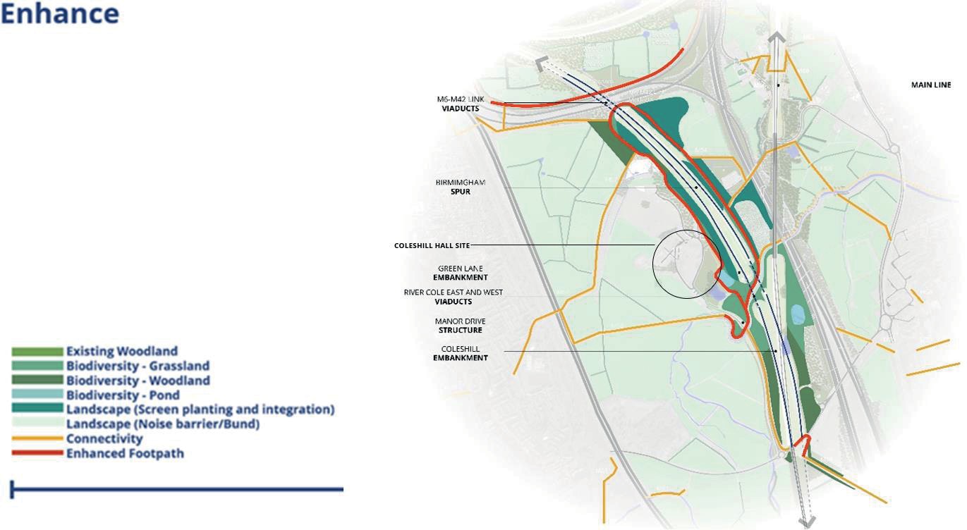
‘A sensitive high value landscape is likely to require a landscape design approach that creates significant screening and integration of HS2 but also develops measures that will conserve and enhance the overall landscape character.’ 7 In delivering a scheme sensitive to the location we put landscape, ecology and water at the forefront of our design to ensure not only the integration of HS2 into the baseline landscape but to create a future baseline superior to that of the existing. The Conservation of existing elements within the landscape is a key principle of the design vision preserving the environment and local landscape character.
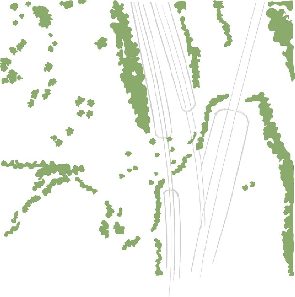
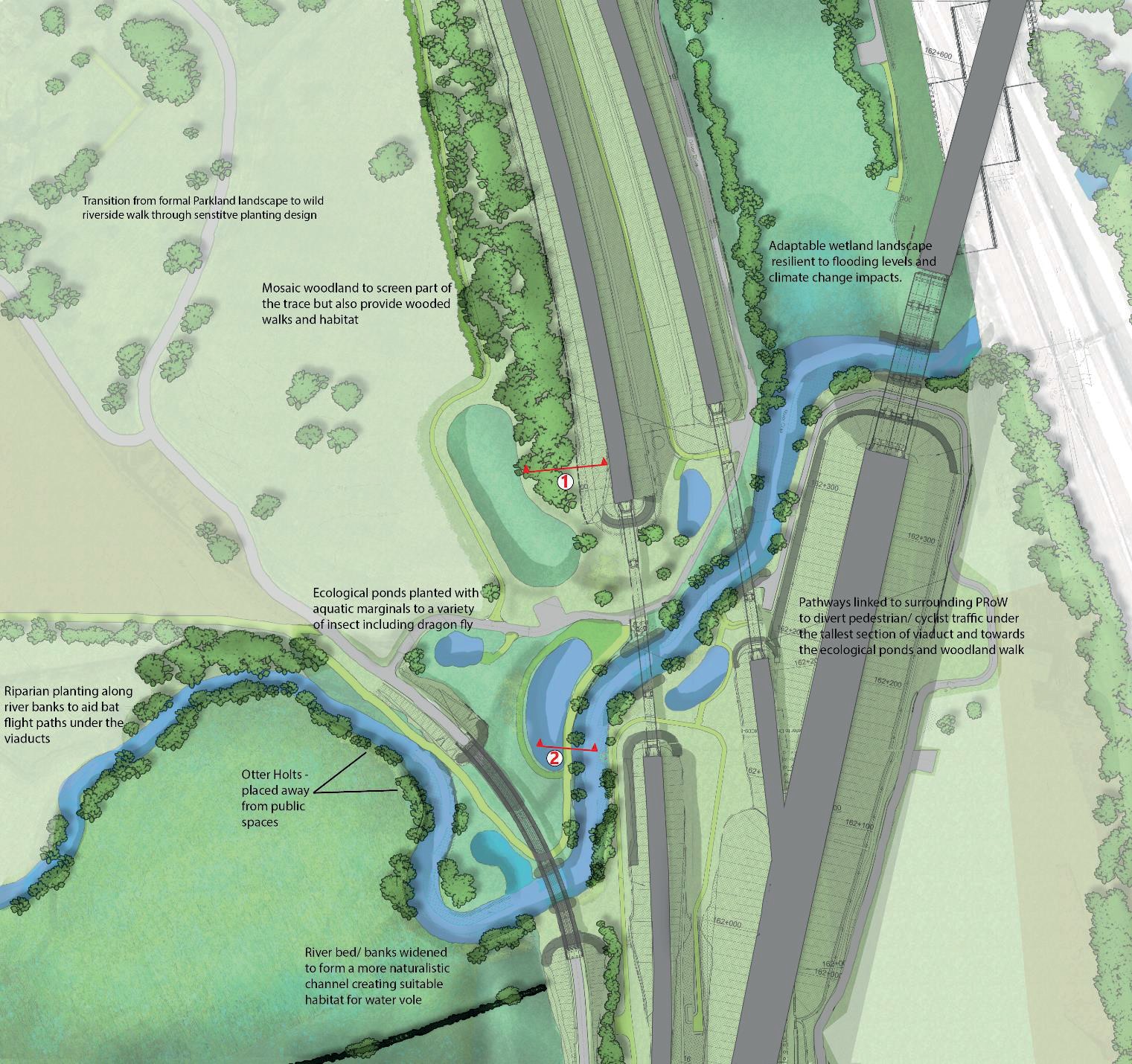
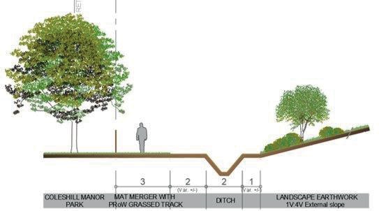
This approach, illustrated in figure 4, is especially important in the vicinity of the River Cole due to local conservational interest. Both the existing Coleshill Manor with its designed landscape and the newly uncovered Coles Hill Hall have influenced the use and management of this dating back centuries. By maintaining as many of the existing hedgerows, agricultural fields and main woodland blocks during construction and into operation, we are able to build on a mature landscape structure and incorporate these characteristics into the design vision.
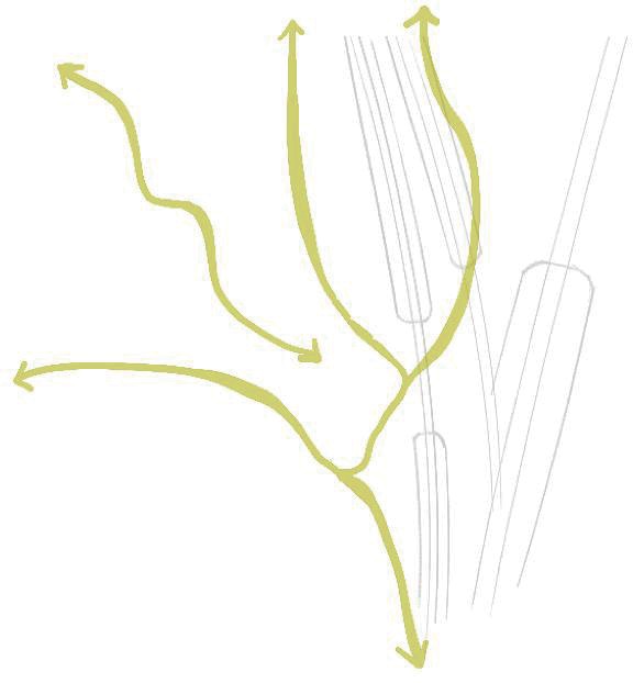
Existing public rights of way also form important elements of the design, maintaining existing links and enhancing access through and around the wider Delta Junction.
….
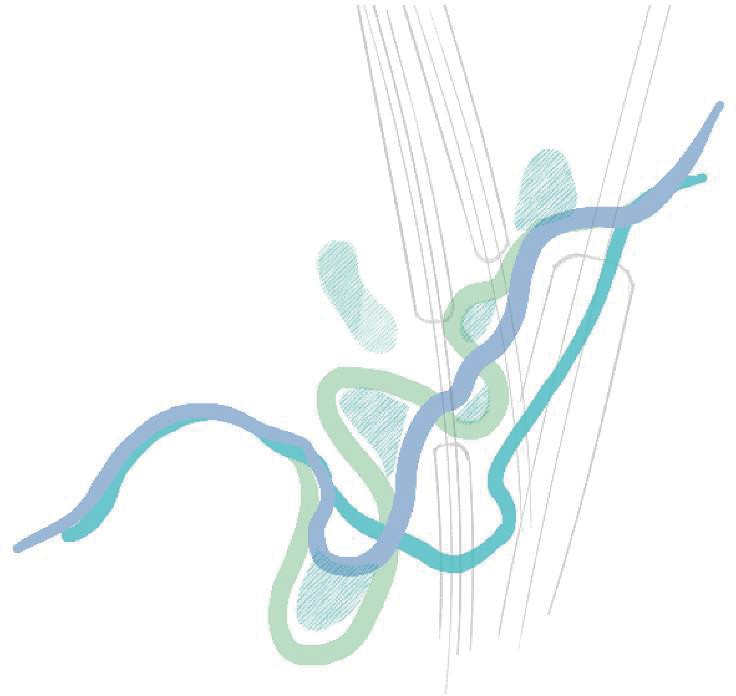
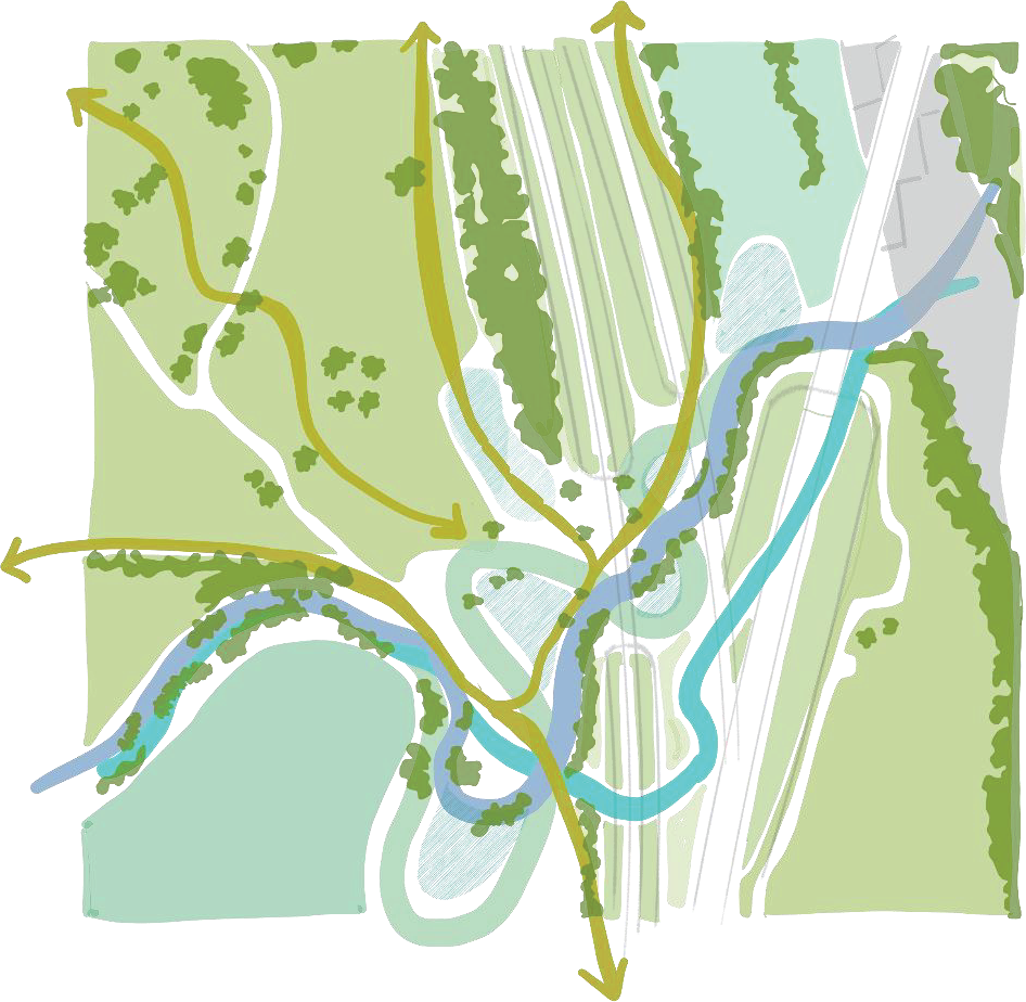
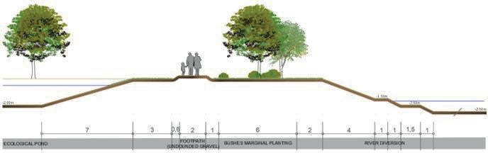
Landscape enhancement is a fundamental principle of the River Cole design. The design builds upon analysis undertaken for the HS2 Phase One Environmental Statement and upon our understanding of the area through subsequent environmental surveys. As figure 5 suggests, the key elements of landscape design in this area are based on the relationship between the River Cole, the emerging understanding of the Coleshill Hall site and the Coleshill Manor parkland landscape. These layers of history portray the River Cole as a popular place of recreation, with a widened section that was possibly created by a small dam or weir and is an element that has been revisited through sensitive design of the river corridor and surrounding landscape.
A key component of the landscape design, linked directly to the River Cole, is the need to realign the river and provide the associated flood compensation areas. In doing this we have worked with the Environment Agency to understand their requirements for a new section of diverted river and integrated this into the surrounding parkland landscape. Working as an integrated design team we have sought to ensure this diversion is as naturalistic as we can make it. We have done this by designing in a diversity of bank shapes, contouring and meanders which when aligned with ecological and landscape enhancement will create a diverse river channel over time.
Rather than solely mitigate views of infrastructure we set out to make features of the HS2 alignment through the design of the structures themselves, using high quality finishes where possible along with sensitive planting patterns and small-scale topographical interventions. In addition, we have developed a strategy to provide greater green and blue connectivity and to mitigate the impacts of construction works on the scheme. We have focused on enhancing connectivity at a human scale and through the provision of a network of footpaths and bridleways, which provide permeability around and through the area for people to experience the natural habitats that we have created.
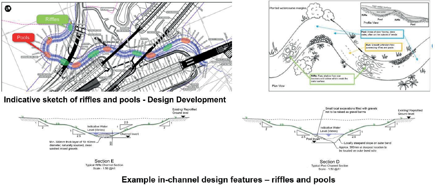
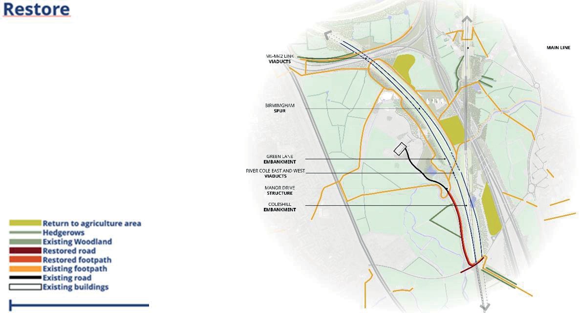
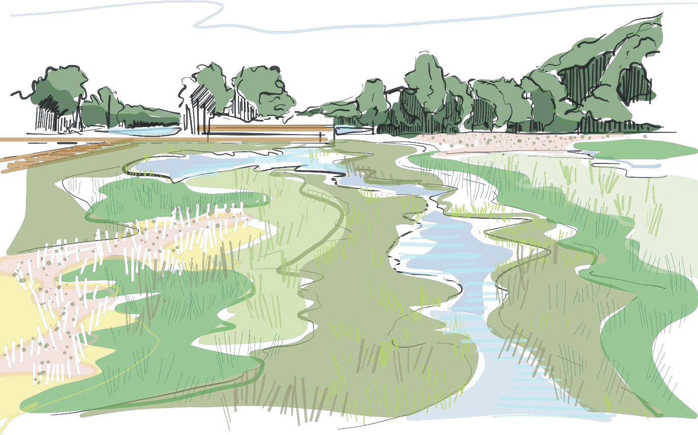
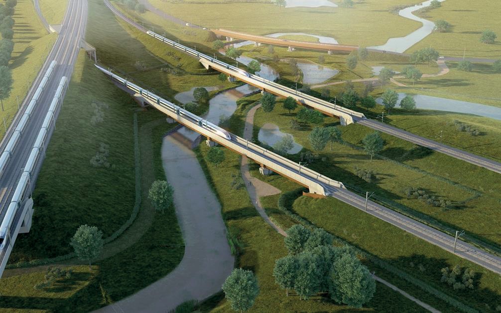
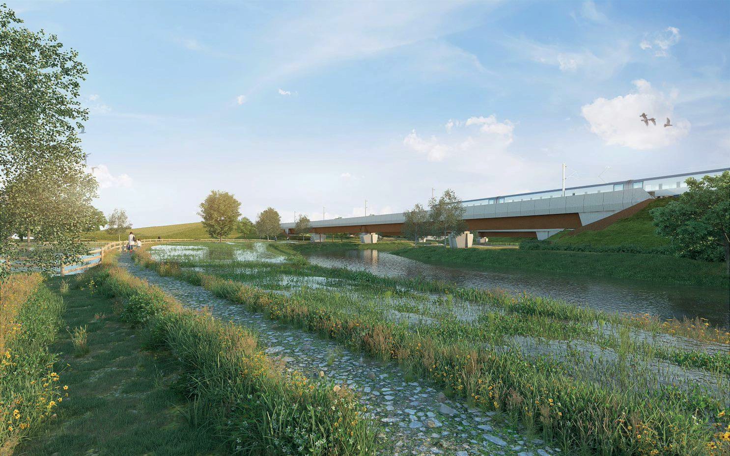
Restoration of the landscape during and after the construction phase will be important, building on the retained landscape features and the unique character of the area will integrate our design vision into the landscape in a legible way. The realignment of the river will benefit from a more naturally flowing design with enhanced profiles which will allow shallows, riffles and pools to be created, which will provide shelter, food, foraging and breeding opportunities for a variety of wildlife species including plants, amphibians, invertebrates, birds, bats and other mammals. With reconnected footpaths, in addition to other enhancements, we can deliver an accessible, biodiverse landscape which benefits both the environment and people living and working locally, figures 6 and 7.
Through our analysis of the landscape and environmental context of the River Cole viaducts it was clear that to attempt to change the unique character of the area was not an appropriate solution. However, there are elements of the existing landscape that require some change in order to deliver our design vision.
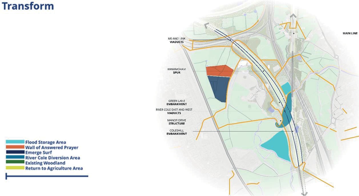
There are a number of approved developments noted on figure 8 that will transform the natural environment as well as consented developments delivered by third party developers that will become local destinations attracting visitors to the Delta area. Most notably a large Christian monument called the Wall of Answered Prayer and an aquatic centre called Emerge Surf Birmingham. Our design vision has been developed to be flexible and adaptable, safeguarding for the integration and surface access to them.
Key design interventions that will transform the River Cole landscape mainly include the development of wetland ecology around the river, with the creation of two RFS areas and of ecological ponds and with footpaths running under the viaducts which will allow users to experience these interventions close up.
Design Strategy – Landscape/Ecology/Water/Heritage
HS2 crosses the Delta Junction on a series of viaducts and embankments, at different levels, creating a series of new landmarks visible at long distances within the open and often expansive landscape. The landscape strategy, therefore, is aimed at creating a relationship between the wider landscape and HS2 assets rather than simply screening the alignment with vegetation.
This section of HS2 passes close to the Coleshill Manor, a parkland landscape adding value to the title ‘Heritage Hotspot.’ The Parkland is designed in the style of Repton or Brown with typical 18th Century English design elements including manicured lawns, intermittent groups of trees and standalone feature trees whilst also utilising the meander of the River Cole to full effect. HS2 passes directly over the River Cole in this location. The River Cole was once a popular recreational hub, with a widened section that was possibly created by a small dam or weir. Visitors using the boating lake, would walk across the parkland lawns towards the manor which created a strong sense of place and an element of grandeur to the Manor. The redesigning of the River Cole riparian landscape brings with it the opportunity to recreate links between the park and its river.
The landscape strategy has been developed to reconnect and strengthen the historical relationship between these elements through sensitive landscape and ecological design that mirror the layers of the landscape’s historical past. To create a multi-layered landscape that enhances the existing site conditions, providing flood alleviation, connectivity, recreation, habitat creation, whilst enhancing the approach to the Coleshill Manor, by creating a continuation of the Manor’s historic landscape and reinterpreting this ancient link between the river and the house.
Taking inspiration from the Manor’s parkland, the development of recreational green space alongside the river will enrich the existing estate and expressing those important historical layers including the historical gardens, displaced river and the river floodplain landscape. The addition of circular PRoW routes gives a less glamorous part of HS2 multifunctionality by incorporating a proposed maintenance access track, part of Green Lane and areas adjacent to the river. This is aimed at boosting the areas’ recreational value, linking to the wider network of PRoW whilst also emulating the historical informal routes from the Manor to the former boat house.
The design of the viaducts, abutments and piers watercourse has taken the displaced watercourse into consideration. HS2 Ltd has committed to providing a high-speed railway that is resilient to flooding and that will not increase the overall risk of flooding elsewhere, and this is very much the case at the River Cole. This means that the watercourse crossings will be designed to convey the 100-year return period flow, including an additional flow allowance for climate change.
Given that the viaducts’ abutments, piers and approaching embankments, upon which HS2 will run, encroaches on Flood Zones 2 and 3, the displacement of floodplain storage volumes will be compensated through the creation of two Replacement Floodplain Storage (RFS) areas, one to the west of Coleshill No.3 Embankment and one between River Cole East Viaduct and the M42 Coleshill Box Structure. The two RFS areas are created to enable the river to flood and then slowly recede after a storm event. The landscape and ecological design strategy will aim to utilise the RFS to mimic the historic shape, width and meander that characterised the River Cole prior to it being channelled, returning the adjacent land to a more natural, pastoral landscape whilst also enhancing the biodiversity through sensitive wetland planting design. To enhance this further, the newly aligned River Cole will have two low sections of bank which have been designed to allow grazing animals access to the water.
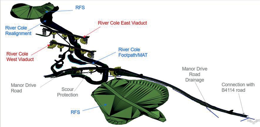
Due to the number and positioning of the viaducts, the River Cole will be realigned to pass between the embankments and viaduct piers, under the River Cole West and East viaducts. The realignment will be designed to mimic the existing channel capacity, minimising any impact on flood risk upstream and downstream. The design of the river diversion and RFS in this area will be integrated with the landscape proposals and seek to maximise ecological value of the site and respond to the local context which includes the designed landscape surrounding Coleshill Manor. Positive drainage solutions have also been implemented in relation to the viaduct structures, with all surface water runoff being managed in a closed system of pipes and gullies to quickly evacuate stormwater.
Enhance river and wetland layout
Enhance the river meanders to design the new ponds, paths and flood areas.
Integrate historic and natural vegetation patterns
With a transition between the informal patterns made of large, isolated feature trees of the Manor Garden and the wild riverside vegetation to the grid pattern of the Elizabethan Hall.
Express historical links between the Manor and the river
Reinterpreting the former informal connections between the boat house and the gradual discovery of the Manor from the river through filtered views and viewing areas.
Add a contemporary layer
Using HS2 to create a new space within close proximity to the viaduct and connect the green corridor to historical vegetation layers and heritage assets.
The River Cole, a sensitive ecological receptor in itself, passes through a diverse landscape all of which has been incorporated into the design for the river displacement and site. The land required for the construction of the River Cole Viaducts consists primarily of agricultural land, species rich grassland, lowland meadows and broadleaved deciduous woodland. Although no Local Wildlife Sites (LWS) are within the land required or directly adjacent to the construction area, wildlife conservation does exist in the wider study area most notably at Coleshill Farm LWS, Wheeley Moor Farm Meadow LWS and Coleshill Park Belt LWS.
The ecology of the site is highly influenced by the River Cole, which supports a wide variety of protected species and priority habitats. The grassland along the banks of the River Cole consists of five large cattle-grazed pasture fields containing the perennial rye grass community Lolium perenne – Alopecurus pratensis grassland. The river itself is to be realigned, as stated in the ES. Realignment works on the River Cole will result in the permanent loss of approximately 660m of existing channel, however any impact on watercourse habitat and function is considered likely to be offset by the increase in channel length within the realigned section.
Due to the presence of valuable ecological assets and the significant change that will be caused to them due to the diversion works, sensitive design must be underpinned by clear objectives with the aim of mitigating any impacts to these valuable receptors and enhancing them where possible. The objectives for the River Cole diversion are as follows:
- During construction and operational phases, losses of vegetation and habitats along the viaduct footprint will be minimised.
- Reduce environmental impacts.
- Achieve the target of ‘no net loss’ in biodiversity for replaceable habitats.
To achieve these goals the design has included a range of important ecological mitigation features, with habitat creation at the forefront of this.
Habitat creation in the River Cole area plays a key role. The realignment of the river provides an important opportunity for swathes of wet grassland and riparian planting along its banks. This grassland planting will help to provide continuation of grassland habitat surrounding the River Cole.
Overall, this is aimed at tying into the greater area set around the River Cole ensuring suitable ecological mitigation, providing ponds, wet grasslands and management of existing woodland to support the rich abundance of species already present.
Habitat creation in the area is largely focused around ensuring ‘no net loss’ to biodiversity as detailed in HS2 Phase One Information Paper on Ecological Impact8. This has encouraged the creation of new sites that represent not only those lost close to the individual assets but those lost elsewhere on the scheme. This is evidenced in the habitat creation surrounding the River Cole Viaducts. Due to the loss of 7.2 ha of rush pasture and grassland within Coleshill Sewage Works grassland LWS and Coleshill Hall Farm LWS and the approximate loss of 17.3 ha of species rich grassland along the banks of the River Cole, the new habitats created around the River Cole viaducts will be characteristic of these LWS’s, enhancing the schemes link to the wider landscape and importance to the community as a whole.
The wide array of habitats present surrounding the River Cole supports a large density of protected species. Most notably the diversity of bat species. These bat species use the River Cole as a key ecological corridor to travel throughout the local patchwork of habitats. Records show that all three UK species of Pipistrelle, various Myotis species, Leisler’s, Noctules and Barbastelle’s use the river and the surrounding landscape. It is vital that ecological corridors such as these remain intact. To maintain and enhance the River Coles use as an ecological corridor for bats, woodland and scrub planting will be used to discourage bats from crossing the trace but redirecting them to fly under the River Cole Viaducts, along the river itself.
As well as providing habitat connectivity for bats the River Cole provides a suitable habitat for otters. The design therefore focuses on providing a planting scheme along the newly realigned River Cole that will ensure this suitable habitat is maintained. This riparian habitat created may include natural features such as such as berms, two-stage channels, riffles, pools, and marginal planting, where reasonably practicable. By creating this new habitat, the design ensures that will be no permanent loss to otters’ access to watercourses. In addition to these measures, an artificial Otter Holt will be located on one of the banks of the River Cole Diversion, west of Manor Drive.
Planting palettes were created by DJV following the Warwickshire County Council Landscape Guidelines9 for the Arden area, the Phase 1 vegetation and habitat surveys from the ES and the Warwickshire Landscape and Biodiversity Action Plan (LBAP)10 with appropriate planting mixes selected to ensure that these habitats are successful and the scheme properly integrated into the surrounding landscape, with local legislation forming the backbone of the proposals.
Stakeholder Engagement
People play an integral part in the ethos that HS2 is trying to capture and, as such, stakeholder engagement is high on the agenda, engaging with communities over the lifecycle of the project. Due to the Covid pandemic the traditional community events at the concept stage of the River Cole Key engagement process were unable to take place, so working collaboratively BBV, DJV and HS2 made the decision to reach out to these affected communities and residents in a different way, through the distribution of an informative engagement booklet. This engagement booklet allowed the public and local communities to be involved in the continued development of the design. The engagement booklet was also accompanied by a questionnaire giving the public the opportunity to give feedback on different aspects of the scheme including landscape, ecology, water and heritage. The public were also able to give their feedback through an online questionnaire on HS2’s Warwickshire community website.
Barriers to engagement, created by the pandemic, were ameliorated by ensuring that the booklets were delivered through Royal Mail directly to the affected communities. This was a great success and guaranteed that residents received the information and were made aware of our intentions. We also gave local communities the opportunity to ask their questions through an online webinar. BBV presented an informative presentation and a panel of specialists communicated the different aspects, answering questions as they arose.
BBV also updated local authorities, the MP for the local area and groups such as the North Warwickshire Special Management Zone, through virtual engagement meetings.
As the COVID-19 restrictions relaxed during July 2021, BBV were able to complete follow up engagement events within the community, to provide feedback to the public. These events were organised with a focus on ‘you said, we did’. Identifying aspects of the design the community’s feedback had been able to enhance and influence.
All these engagement activities were positive ways of keeping the local stakeholders in the area up to date with the design and construction proposals of the River Cole Viaducts and surrounding landscape.
With regards to affected Planning Authorities a series of presentations were made to an Independent Design Panel including representatives of Warwickshire County Council and North Warwickshire Borough Council. This series enabled the design to evolve alongside public opinion and ensured an open dialogue between each party throughout the process. As part of the public engagement process for the River Cole Viaducts, BBV asked for feedback on numerous different aspects. From a landscape perspective, the public were very keen to introduce good quality, well supported cycle and pathways to enhance community connectivity within the area. The public showed a great affinity towards retaining as much of the existing habitat as possible and making sure we enhance habitat creation for wildlife going forward.
All feedback from the public, the local authorities and HS2 Independent Design Panel were then considered during the design of the viaducts and the River Cole region as a whole. The decisions and options for design have, therefore, been taken based on public engagement, design, efficiency, and sustainability grounds.
Lessons Learned
In conclusion, the design process for the displaced River Cole and surrounding landscape has been extensively driven by habitat creation, improved biodiversity, landscape enhancement and historic preservation which has been realised though the collaboration of several disciplines within the DJV, open dialogue with stakeholders and is aimed at climate resilience and a richer tapestry of life for all those expected to use the landscape.
Throughout this process the focus has been on delivering not only a suitable scheme in terms of high speed rail infrastructure but delivering a scheme that: conserves all that is important and unique about the baseline landscape; enhancing those features of importance through sensitive design; restoring lost landscapes either by creating a link to the land use interests of the past or restoring broken habitats through landscape and ecological design; and transforming the landscape through good quality design, boosting biodiversity and ensuring the landscape is more adaptive and resilient to threats such as climate change.
Collaboration between disciplines has allowed for a more holistic approach to river displacement, evidenced though design evolution such as shallower banks to achieve natural, stable conditions based on channel depth, optimising the approach to include a 3-stage channel helping to maintain velocities and water depth in low flow conditions, avoid sediment deposition, ensure sufficient depths for fish species and allow for additional habitat creation along the river margins.
The catalyst behind this strong design ethos has been the open, transparent and frequent dialogue with important stakeholders including Local Planning Authorities, Third party developers, local communities and many others. Involving these stakeholders at the earliest possible occasion and using imaginative methods during the pandemic to keep these parties updated and involved in the design process has helped the DJV design team in unearthing a real sense of place and understanding what is important to local communities, as well as having their input on environmental issues such as flooding and climate resilience.
Following the HS2 Design Vision guidance and an emphasis on People, Place and Time the DJV has been able to deliver proposals for the River Cole and surrounding landscape that celebrates the local with a coherent national narrative, shows a commitment to the natural world, boosting biodiversity and habitat creation whilst enforcing a resilience to future climate impacts and designing a place that supports a quality of life underpinned by engagement with communities through the lifecycle of the project. Therefore, it is the DJV’s belief that these design principles set by HS2 and adhered to by the design team will stand the test of time, particularly in light of increased national importance placed on biodiversity and habitat creation with the
Environment Act 2021 as the catalyst. The extensive environment programme put in place by HS2 to tackle environmental impacts, is underpinned by strong collaborative and innovative design and despite the enormity of HS2 and it’s ‘Green Corridor’, these principles are entirely scalable, as evidenced through the River Cole KDE, a small but integral part of the HS2 route, with the potential to case study environmental best practice and pave the way for better environmental design nation-wide.
Acknowledgments
This paper and the research would not have been possible without the DJV design team incorporating specialist from a range of disciplines across SYSTRA Ltd, Mott MacDonald Ltd, Weston Williamson and Partners and PCP Architects Ltd.
Special thanks is also extended to Marion Gourlay and Deborah Nash at Transport PR for their willingness to review and comment on draft reports, offering insight into a more concise writing style.
Finally, thanks to Leigh Brewin, Jon Morgans and Henry Casement of SYSTRA Ltd for their unparalleled support in allowing me to deliver this paper and its findings in a timely manner.
References
- HS2 Green Corridor Prospectus [Internet]. HS2; 2020 [cited 28 April 2022].
- NCA 97 Arden [Internet]. 1st ed. Natural England; 2014 [cited 26 April 2022].
- HS2. LONDON-WEST MIDLANDS ENVIRONMENTAL STATEMENT – CFA 19: Coleshill Junction ES Volume 2. HS2; 2013.
- North Warwickshire Landscape Character Assessment – Warwickshire N. Document downloads – Forward Planning | North Warwickshire [Internet]. Northwarks.gov.uk. 2010 [cited 26 April 2022].
- Warwickshire, Coventry and Solihull Green Infrastructure Strategy [Internet]. [cited 26 April 2022].
- HS2 Design Vision [Internet]. HS2; 2017 [cited 26 April 2022].
- HS2. River Cole Viaducts KDE Design and Access Statement. p. 27.
- Ecological Impact [Internet]. HS2; 2017 [cited 28 April 2022].
- WCCC-863-667 [Internet] Warkwickshire.gov.uk. 1993 [cited 26 April 2022].
- Warwickshire, Coventry & Solihull Local Biodiversity Action Plan (LBAP) | Warwickshire Wildlife Trust [Internet]. Warwickshirewildlifetrust.org.uk. [cited 26 April 2022].