Route-wide contamination risk assessment modelling in support of a sustainable earthwork material reuse framework
High Speed Two (HS2) aims to re-use a minimum of 95% of soils generated by the scheme. This poses challenges for the re-use of potentially contaminated materials. In support of a Material Management Plan for the northern section of the HS2 Phase One works, a contamination risk assessment was produced to derive Acceptability Criteria (ACs) to allow the sustainable reuse of excavated soils. The works were unusual as they were undertaken at a strategic level for the whole of the northern route. Utilising the Definition of Waste: Industry Code of Practice (DoWCoP) approach, this material could be diverted from becoming a waste and be reused achieving financial, carbon, time and environmental cost savings.
The methodology generated eight scenarios to account for the variability in hydrogeological conditions along the route, and contaminant fate and transport modelling produced relevant contamination thresholds for each asset, which will be utilised by the site teams for material movements.
These works have successfully delivered a robust but necessarily conservative set of ACs for protection of human health and the environment which were fully accepted by the Environment Agency upon first submission. This project supports a demonstrable legacy of sustainable earthwork material reuse.
Part of this unique, innovative approach was to classify assets on the basis of two key parameters (depth to groundwater and permeability) in order to provide the basis for a manageable number of acceptability criteria suites applicable to the assets on the scheme.
This work is considered leading edge due to the application of contaminant fate and transport models to a long, linear scheme of variable sensitivity to water contamination, owing to variations in geological and hydrogeological conditions. The methodology employed can be applied to future linear schemes to enable effective development of robust ACs for large scale materials reuse.
- Written by
-
Tim Hodges (Mott MacDonald/Mott Macdonald Systra DJV)

-
Lucy Bethell (Mott MacDonald/Mott Macdonald Systra DJV)

- Resource type
- Resource type: Technical Paper
- Intended audience
- Consultants
- Tags
- materials reuse, sustainability, contaminated land risk assessment posts
Introduction
This paper is presented as part of the works to deliver the Main Works Civils Contract (MWCC) for the northern section of High Speed Two (HS2) Phase One including Long Itchington Wood Green Tunnel to Delta Junction and Birmingham Spur and the Delta Junction to the West Coast Main Line (WCML) tie-in, being delivered by the BBV Integrated Project Team.
HS2 aims to re-use a minimum of 95% of soils generated by the Phase One scheme. This poses challenges for the re-use of potentially contaminated materials. Such challenges are magnified by the presence of large volumes of potentially contaminated materials in heavily industrialised areas through which the railway passes.
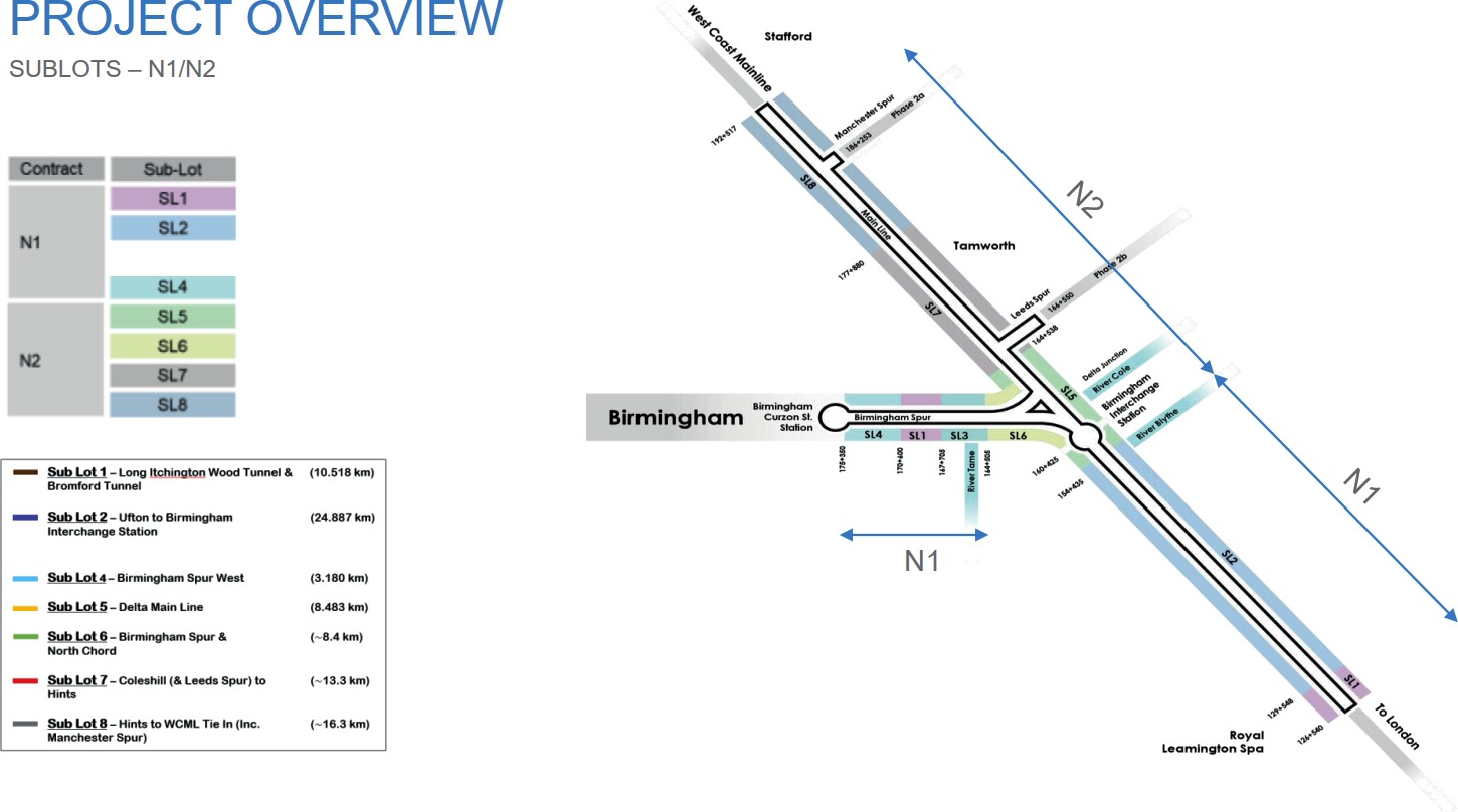
The Phase One Northern Lots N1 and N2 are located in and around the West Midlands conurbation, where the railway passes through the heavily industrialised River Tame and River Rea Valleys on entry to eastern Birmingham.
Lots N1 and N2 are divided into eight sublots (SL) referred to as SL1 to SL8, with N1 in the south comprising SL1 to SL4 and Lot N2 comprising SL5 to SL8. This is illustrated in Figure 1.
This paper outlines a risk assessment approach to support Main Works Civils Contractor Balfour Beatty Vinci’s (BBV’s) Material Management Planning framework. The contamination risk assessment framework was developed by the Design Joint Venture (DJV), Mott MacDonald Systra.
The aims of the project are to:
- Ensure the protection of the environment and human health through the recovery of soils
- Contribute towards sustainability objectives for the scheme through recovery of soils and minimisation of waste achieving financial, carbon, time and environmental cost savings.
The principal project deliverables were risk-based contamination acceptability criteria for re- covered soils. These criteria are used to define contamination concentrations which are deemed to pose a low risk to human health and the environment as part of a material management and earthworks design framework.
Material Management Planning
The HS2 Material Management Plan (MMP) Framework Technical Standard [1] demonstrates how the CL:AIRE Definition of Waste Development Industry Code of Practice (DoWCoP) [2] will be met for the scheme. DoWCoP, first published in 2008 “provides a clear, consistentand efficient process which enables the reuse of excavated materials on-site or their movement between sites”. DoWCoP was updated to version 2 in 2011 and this version is implemented by the HS2 Technical Standard.
Fundamentally, DoWCoP establishes four factors to demonstrate the recovery of soil waste, allowing the material to be reused outside of the waste management legislative framework as an acceptable earthworks fill. These are:
- Protection of human health and the environment
- Suitability for use, without further treatment
- Certainty of use
- Quantity of material
For this scheme, factors 1 and 2 are demonstrated through achievement of risk-based acceptability criteria and achievement of specified landscaping or structural class. Factors 3 and 4 are demonstrated through design documentation and mass haul and are not considered as part of this paper.
The DoWCoP defines two potential development routes to demonstrate waste recovery which are:
- Route A for land where contamination is suspected or known to be present; and
- Route B for land where contamination is not suspected.
Under route A, excavated material will require detailed assessment to determine its suitability for reuse. This risk assessment is intended to form part of the route A development framework. Potentially contaminated materials are defined as:
- Made ground
- Natural materials that exhibit evidence of anthropogenic contamination from point sources
DoWCoP identifies three basic steps for best practice in the recovery of waste:
- Ensuring that an adequate Materials Management Plan (MMP) is in place, covering the use of materials on a specific site;
- Ensuring that the MMP is based on an appropriate risk assessment, that underpins the Remediation Strategy or Design Statement, concluding that the objectives of preventing harm to human health and pollution of the environment will be met if materials are used in the proposed manner; and
- Ensuring that materials are treated and used as set out in the MMP and that this is subsequently demonstrated in a Verification Report.
This paper reports the route wide contamination risk assessment modelling developed to support the Route A MMP.
Spatial Scope
The HS2 MMP Framework [1] defines the phase One Contractor Lots as “Sites” for the purposes of the “Site of Origin” scenario. Material generated within the Northern Lot site boundary could therefore be recovered within the same boundary in accordance with the MMP Framework, avoiding the requirement to transfer material as a waste between work sites. Acceptability criteria were to be generated for the principal reception locations for recovered materials, namely embankments and landscaping areas along the mainline between Leamington Spa in the south and Handsacre in the north. This includes the Delta where the mainline and Birmingham Spur split east of Birmingham, with a high demand for landscaping material. Principal areas of material generation are located within cuttings on the Mainline and Birmingham Spur.
Conceptual Model
The first step in the development of the risk assessment was the establishment of a conceptual model. This model identified landscape bunds formed of recovered materials as the source. Pathways linking the source to human, environmental and property receptors are illustrated diagrammatically below in Figure 2.
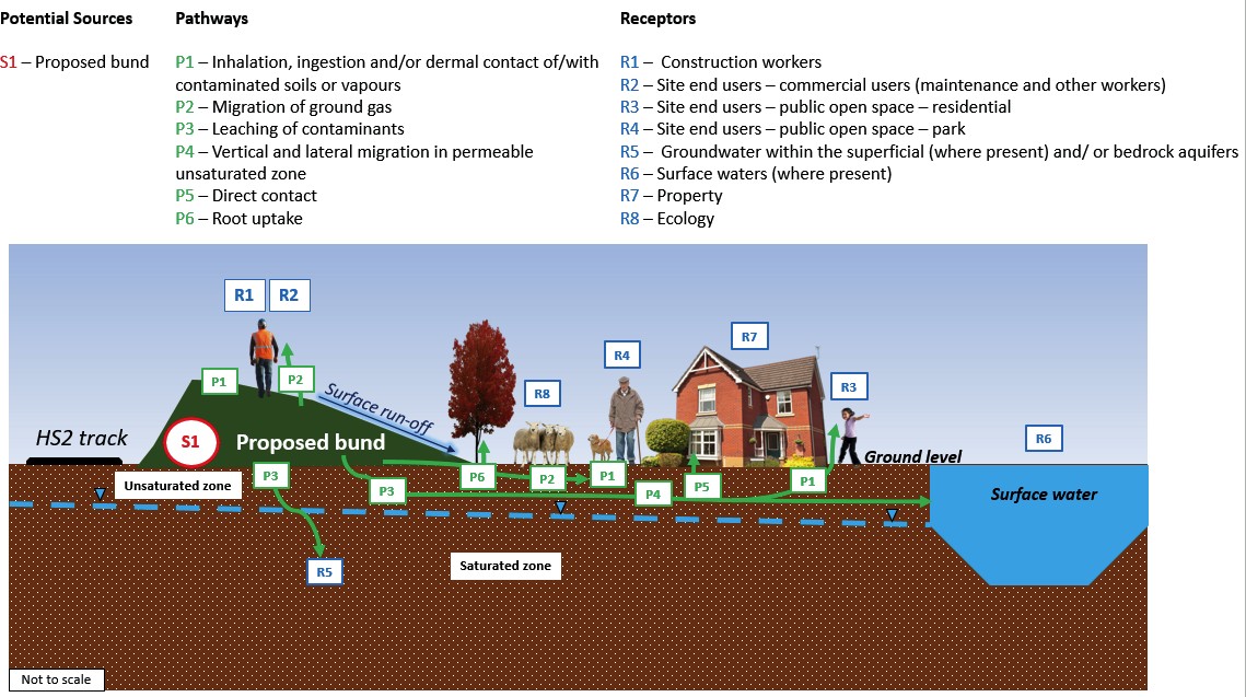
It is noted that lateral migration of contaminants in the unsaturated zone is only likely where there is a low permeability saturated zone (for example the Mercia Mudstone Group) and thus may not be active across the whole route. The saturated zone is only considered as a receptor and not a pathway for this CSM. Further detail is given in the Controlled Waters Risk Assessment Section.
Acceptability criteria as part of the risk management framework
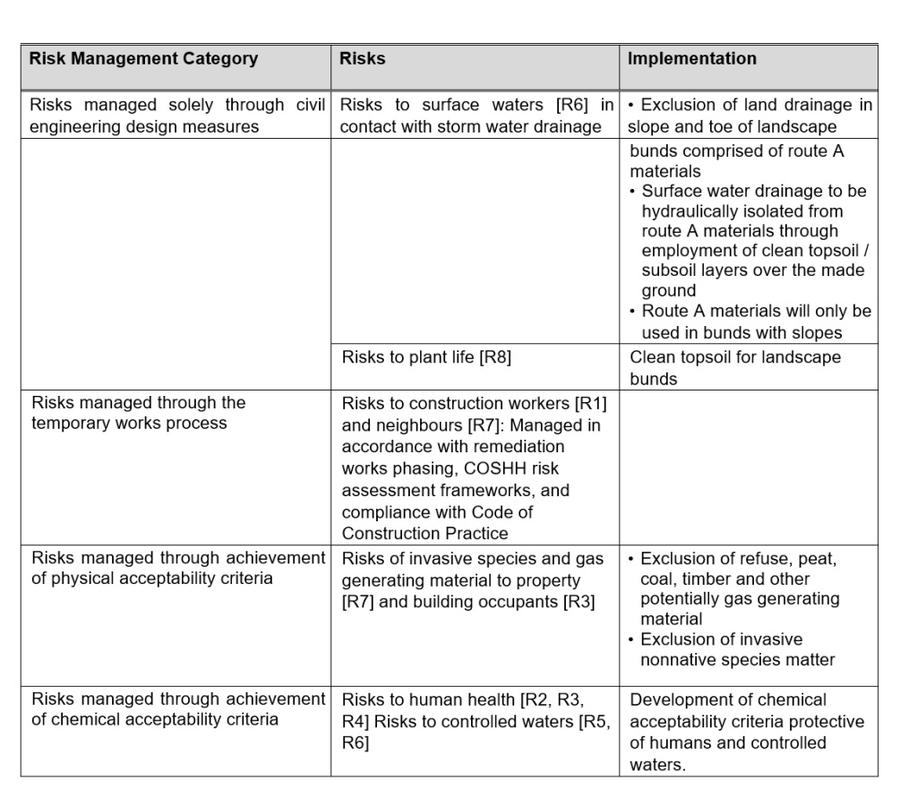
It was clear from the conceptual model that the management of contamination risks fell into four categories:
- Risks managed solely through civil engineering design measures
- Risks managed through the temporary works process
- Risks managed through achievement of physical acceptability criteria
- Risks managed through achievement of chemical acceptability criteria
The management measures were apportioned to each receptor are summarised in Table 1 below.
Table 1. Risk management summary
The derivation of ACs is undertaken to address Factor 1 of the four principles of material as non-waste in DoWCoP, namely “protection of human health and protection of the environment”.
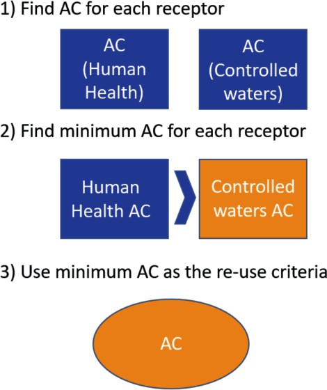
In order to determine ACs for each of the defined Scenarios (Table 2), acceptability criteria (AC) for each receptor (human health and controlled waters) were generated for each determinand. The final AC for each determinand is the lowest receptor specific AC. This process is shown in Figure 3.
Human Health Risk Assessment
Human health AC were assessed using published and bespoke Generic Screening Criteria (GSC) derived using the SP1010 framework developed by Contaminated Land: Applications in Real Environments (CL:AIRE) on behalf of the Department for Environment, Food and Rural Affairs (DEFRA) [3] , and the Environment Agency Contaminated Land Exposure Assessment (CLEA) [4] Framework.
Under both frameworks, GSC have been developed for a range of generic land use categories. The commercial and public open space park (PoSpark) end uses are considered to be protective of human receptors across the Proposed Scheme. However, there are certain discrete areas of the re-use boundary that are located close to residential properties. This includes public rights of way which may be within close walking distance of residential properties. Public rights of way in these areas are understood to be covered in a layer of clean gravel thereby minimising exposure to underlying contaminants. As a result, human health AC adopted in this risk assessment are based on public open space (park) and commercial land uses.
Where available, the GSC are the Category 4 Screening Levels (C4SLs) published in the SP1010 policy companion document by DEFRA (2014) [5] . C4SLs are based on Low Level of Toxicological Concern “which represents the estimated concentration of a contaminant [expressed as a daily intake] that poses a low risk to human health”. This is regarded as far below an intake level that would represent a Significant Possibility of Significant Harm (SPOSH) to human health. C4SLs have been published for a Soil Organic Matter (SOM) of 6%. These have been remodelled using CLEA Software v 1.071 assuming identical model parameters to those published, but with SOM contents of 1% representing a typical lower bound for this parameter. Published GSC for all other organic contaminants considered in this study assume a SOM of 1%.
C4SLs have been published for a limited number of determinants. Where no C4SL exists, Suitable for Use Values (S4ULs) published by Land Quality Management Ltd (LQM) [6] , have been used. S4ULs are based on Health Criteria Values (HCVs) representing a minimal / tolerable level of risk. This is regarded as far below an intake level that would represent a Significant Possibility of Significant Harm (SPOSH) to human health.
C4SLs and S4ULs have been published for commercial and PoS(park) generic land uses. Where C4SLs and S4ULs do not exist, Generic Screening Criteria were modelled with CLEA v1.071 using HCVs published by CLAIRE, Environmental Industries Commission (EIC) and The Association of Geotechnical and Geoenvironmental Specialists (AGS), (2010) [7] and pathway and receptor parameters recommend in DEFRA 2014 under the SP1010 framework [3].
Controlled Waters Risk Assessment
The key parameter in considering materials reuse, and thus materials suitability, across the route relates to the in-ground conditions where the material will be placed and therefore the geology and associated hydrogeology. Due to the length of the route, the geology and hydrogeology vary from south to north and, in many cases, over the length of one asset.
Therefore, robust review and consideration of the geological and hydrogeological conditions is undertaken using ground investigation data (in situ and laboratory testing) presented in borehole logs, long sections and Leapfrog geological models. The superficial and bedrock geology is shown in Figure 4 and Figure 5.
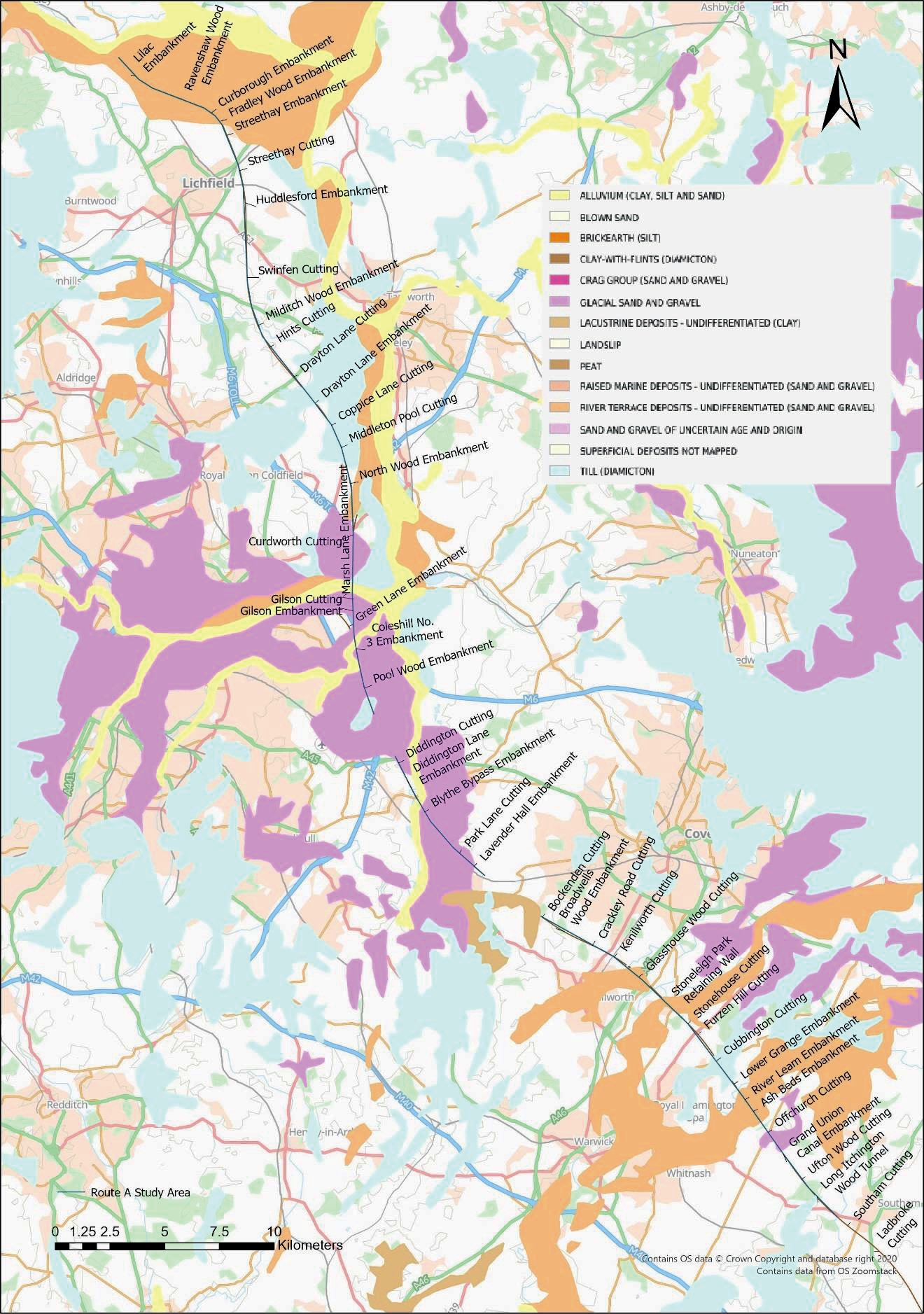
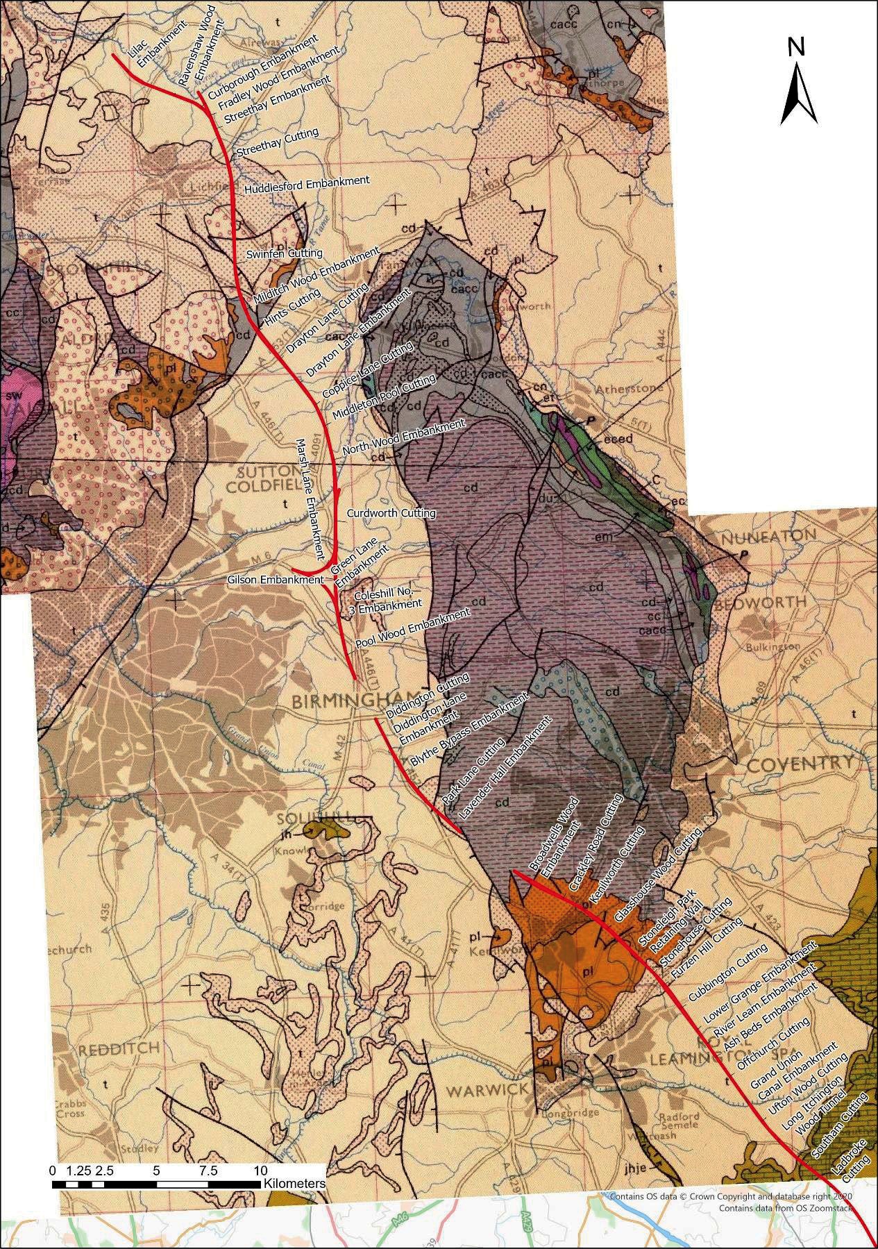
To reflect this variability and to maximise efficiencies for reuse, seven acceptability criteria suites have been defined which are intended to be protective of controlled waters and human health of Commercial and Public Open Space (Park) users across the entire Northern Contract area. For assets which do not fit within these seven acceptability criteria suites (discussed further below), a site specific “Scenario 8” would need to be derived.
To address the natural hydrogeological variability, suites of contamination acceptability criteria have been defined to be applicable to a range of unsaturated zone depth and permeabilities (groundwater risk scenarios) at the point of material placement. A summary of the groundwater risk scenarios covered by the suites (numbered 1 to 7) is provided in Tables 2 to 4.
Where the underlying shallow geology is of higher permeability, migration of contaminants from the reused material will occur more rapidly through the unsaturated zone to the groundwater receptor. In addition, where there is a shallow water table, travel times will be shorter than where a deeper water table is present.
Table 2. Groundwater risk scenarios
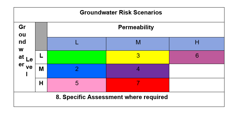
Table 3. Permeability parameters
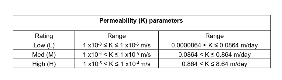
Table 4. Depth to groundwater parameters
Where there is a high permeability and medium or high groundwater level, potentially contaminated materials will not be used. However, if there is a need to use Route A material at these locations, scenario 8 will be used to develop site (asset) specific criteria.
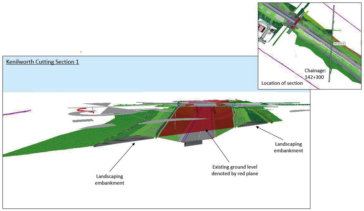
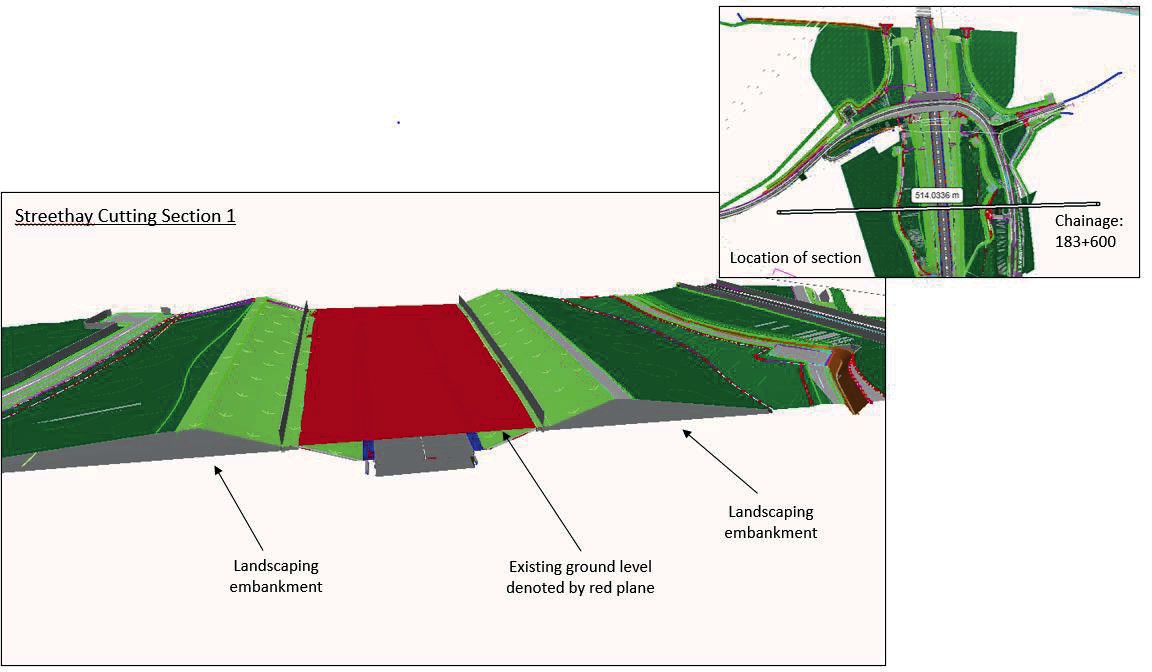
All seven scenarios assume that the material is to be placed above existing ground level and above the water table. A number of assets (Kenilworth Cutting, Roughknowles Wood Cutting, Swinfen Cutting and Streethay Cutting) will be subwater table, at least along some of their lengths. A review of the design of these assets was undertaken to confirm that the landscape bunds containing Route A material are to be constructed above existing ground levels (and therefore above existing groundwater level). The proposed bund design compared to existing ground level is illustrated for Kenilworth Cutting and Streethay Cutting in Figure 6 and Figure 7.
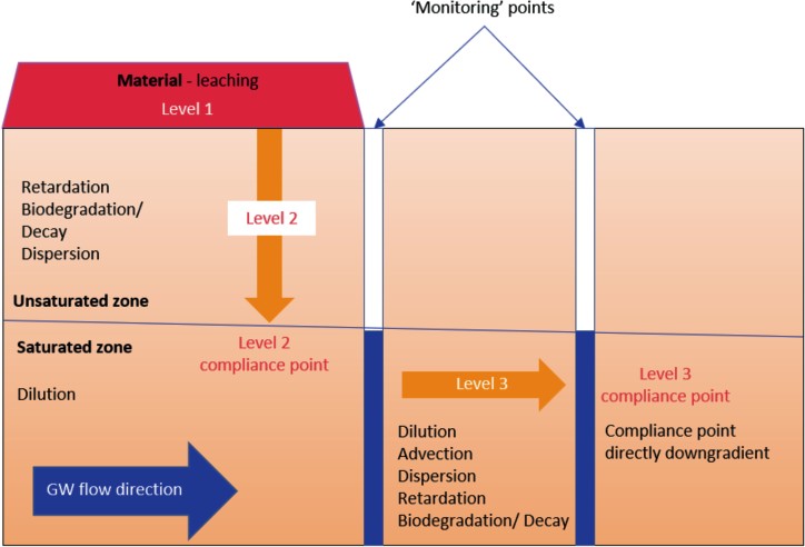
Source-Pathway-Receptor linkage S1>P3, P4>R5, R6 (Figure 2) relates to risks from reused material to controlled waters. A fate and contaminant transport model has been developed to generate Controlled Waters AC using ConSim software [9] (Version 2.5) for each of the seven defined scenarios (Table 2).
ConSim is a fate and transport model which calculates retardation times and concentrations of compounds at a defined receptor compliance point using a tiered analysis, by incorporating the compound concentration at the source. The model incorporates algorithms to quantify the natural attenuation by dispersion, retardation and biodegradation which affect compounds along the flow path from the source.
The ConSim model is tiered into three levels, following the principle of tiered risk assessment. At Level 1 the model predicts porewater concentrations based on the results of the soil concentration analyses and the partitioning between the solid and liquid phases. At Level 2, the model simulates migration through the unsaturated zone to the water table with consideration of degradation, adsorption, dispersion in the unsaturated pathway and dilution within the aquifer. At Level 3 the model simulates the fate and transport of dissolved compounds to identified compliance points or receptors downstream of the point of contaminant entry into the saturated zone, taking account of attenuation within the aquifer.
These are defined by the Environment Agency as:
- Level 1: “Evaluates whether contaminant concentrations in pore water in contaminated soil are sufficient to impact on the receptor but ignoring dilution, dispersion and attenuation along the pathway”
- Level 2: “Considers the possible effects of attenuation processes in the soil and unsaturated zone, and predicts the effects of dilution by groundwater flow below the site”
- Level 3: “Considers the effects of attenuation between the site and a downgradient receptor or compliance point”. This includes:
- “Dilution
- Dispersion
- Retardation
- Degradation by biotic or abiotic processes
- other attenuation processes”
This is shown schematically below in Figure 8.
Determinands (contaminants) of concern were defined based on a review of the soil leachate and groundwater contaminants identified from the ground investigations along the route which represent the likely type of material that will be deposited and based on expert judgement on the sensitivity of receptors in receiving areas. They include a range of inorganics and hydrocarbons including aliphatic and aromatic fractions and Polycyclic Aromatic Hydrocarbons (PAHs). For material that is suspected to contain any additional contaminants of concern, based on its provenance (e.g. Volatile Organic Compounds (VOCs), agrichemicals) etc. then Scenario 8 will be used to derive Acceptability Criteria (AC) for these additional determinands.
The Groundwater Daughter Directive (GDD) (2006/118/EC) defines hazardous and non- hazardous substances for the purposes of groundwater protection. In line with the ‘prevent’ and ‘limit’ aspects of the GDD, for the Consim model the compliance criteria were considered to be the maximum of Minimum Reporting Value (MRV), background concentration or detection limit for hazardous substances and the lowest of Environmental Quality Standard (EQS) and UK Drinking Water Standard (DWS) or background concentration from across the N1/N2 sector where no EQS or DWS are available for non- hazardous substances. The compliance point was defined as the leachate point of entry into saturated zone (Consim Level 2).
Model input parameters were based on Environment Agency guidance, chemical literature sources and site data.
Permeability is considered to be a key input parameter. A review of in-situ testing and Particle Size Distribution (PSD) data (considering the Kozeny-Carmen method [14]) was undertaken to determine the typical lithologies associated with each geological strata. The Kozeny-Carmen method was not used for the modelling, because the in-situ testing values are more representative at this scale. Based on the in-situ testing, permeability classifications were defined for each unsaturated zone lithology based on the permeability bandings for each scenario (Table 2 and 3). Where there is no permeability data for other formations which needed to be included in the modelling, the permeability bands were based upon the aquifer classification and the BGS lexicon of rock units [8].
Based on the approach defined above, the lithologies for modelling are selected based on the known geologies as follows:
- High permeability is represented by a sandy gravel
- Moderate permeability is represented by a clayey sand
- Low permeability is represented by a silty clay
Across a single asset there is variability in the geology of the unsaturated zone. The geology across each asset was reviewed using site data (long sections) and the most permeable shallow lithology (which represents the unsaturated zone) was selected as representative for each asset. However, where that lithology comprised less than 20% of the length of the total asset, it was not considered representative and therefore the next most permeable lithology was selected. A permeability classification (low, moderate or high) was then assigned to each asset.
Groundwater levels for the shallow lithologies for each asset were reviewed based on the ground investigation data and the average groundwater level taken as representative of that asset to reflect seasonal variability. A groundwater level classification (low, moderate or high) was assigned to each asset.
For each asset the relevant scenario was defined based on groundwater level and permeability value of the lithology present using the scenario definitions in Tables 2 to 4. Nine assets were outside the seven standard scenarios, considered as higher risk due to a combination of high permeability and high groundwater level. A site specific risk assessment will be required to allow the re-use of Route A material in these assets.
For calculating infiltration for the assets, consideration was given to climate (rainfall variations along the length of the route), compaction of material, vegetation and slope. As the material will largely be used for landscaping bunds and embankments, a slope runoff factor was applied based on guidance from the Design Manual for Roads and Bridges (DMRB) [15].
Risk based acceptability criteria derivation
Based on the Human Health and the Controlled Waters ACs, the process used to derive ACs for each Scenario is shown in Figure 9.
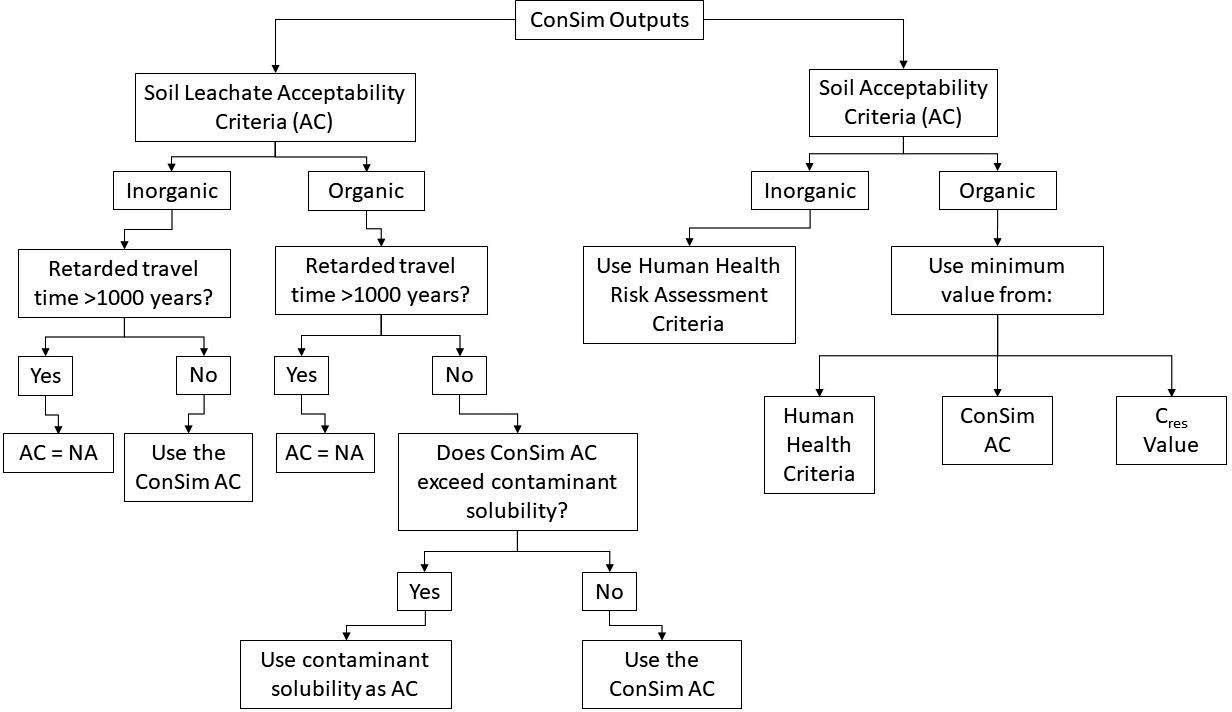
In order to limit the potential for free phase oils, the maximum concentration of the sum of Total Petroleum Hydrocarbons (TPHs) and PAHs is limited to the residual NAPL concentration (Cres) [10]. A conservative value was used for the Cres of a Middle Distillate in a coarse gravel.
For organic leachate ACs, where the model output was above the solubility value, this was limited to the solubility threshold.
Where the retarded travel time for the controlled waters AC is >1000years, in line with Environment Agency guidance [11], no AC was quantified using ConSim.
ACs for asbestos in soils and invasive species were not derived as these will be managed in accordance with the asbestos acceptability criteria and the EWC biosecurity management plan.
A summary of all made ground samples taken in sublots SL1, SL2, SL5, SL6, SL7 and SL8 was screened against the seven scenarios for both soil and leachate tests. The number of samples exceeding the criteria for each scenario was presented as a percentage of the overall number of made ground samples. This demonstrated the likely reuse potential from each sub-lot for each scenario. When the results were compared with the length and estimated area of landscaping that will require material reuse, this demonstrated that there is a fairly consistent opportunity for reuse across the whole scheme, with only slightly lower reuse for scenarios 5, 6 and 7. Scenario 2 presents the best opportunity for material re-use on the scheme with the largest %age of area of all the seven scenarios. Scenario 2 also only recorded 5-11% of exceedances for soil and 0-2% for leachate when the AC were compared to existing ground investigation data across the Sub-Lots.
Remediation framework
A combined Remediation Options Appraisal and Remediation Strategy is in production, implementing the outputs from the risk assessment. The strategy follows the UK Government Land Contamination: Risk Management Framework [12] and includes a remediation options appraisal and remediation and verification sections.
Remediation objectives
The following objectives have been developed to address residual contaminant concentrations in Made Ground and to provide a site suitable for the intended development.
Objective 1: Render risks to controlled waters and human health, from recovered potentially contaminated made ground, as Low.
Objective 2: Through integrated landscaping and topsoil design, ensure that risks to flora are Low.
Objective 3: Provide a practical remediation solution for recovered potentially contaminated
made ground which is consistent with the Contractor’s mass haul strategy and programme.
Objective 4: Maximise recovery of potentially contaminated Made Ground through placement and treatment in order to fulfil the requirements of factor 1 in the DoWCoP.
Remediation optioneering
The remediation option framework is based UK Sustainable Remediation Forum (SurF-UK) methodology (CL:AIRE, 2010) [13] and the associated supplementary reports (2020) [16] . The following remediation options have been considered in the remediation options appraisal:
- Ex-situ soil stabilisation
- Ex-situ bioremediation
- Off-site disposal
Soil stabilisation is likely to be the favoured option for most route A materials generated by the scheme since it facilitates remediation of organic and inorganic species and is broadly consistent with geotechnical stabilisation measures being deployed across the scheme area.
Ex-situ bioremediation is favoured for material subject to high levels of TPH contamination dominated by aliphatic fractions, although its use is likely to be limited in areas of elevated inorganic leachate contamination.
Off-site disposal is likely to be favoured only for those areas exhibiting physically deleterious materials with a low mineral content or for small areas of contamination located some distance from stabilisation or bioremediation facilities.
Application of the ACs in the remediation framework
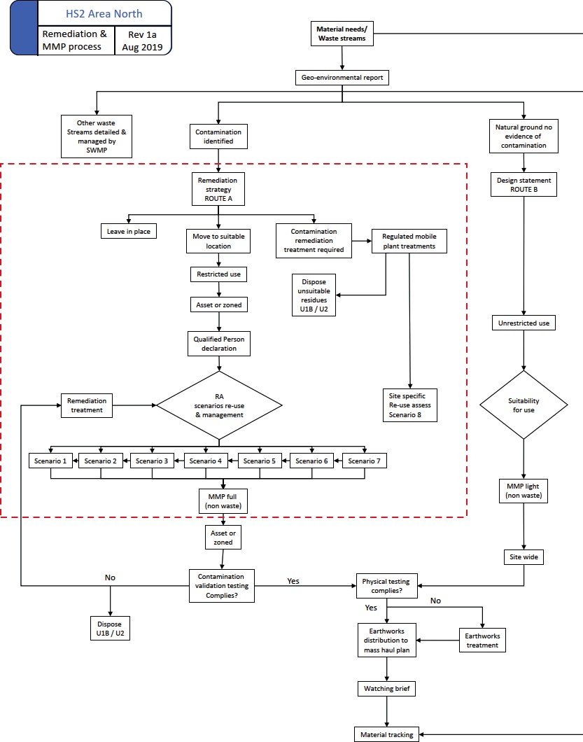
The flow chart below (Figure 10) identifies how the site specific acceptability criteria fit into the overall remediation framework. The critical stages of the framework, listed in chorological order, are as follows:
- Geo-environmental Reporting: Contamination screening through Generic Quantitative Risk Assessment on all contamination data across the scheme to identify contamination linkages greater than Low.
- Route A Remediation Strategy: Methodology for management of re-used materials to ensure that contamination risks to human health and the environment remain Low, and are suitable for use at the point of placement. The Remediation Strategy applies the route A risk assessment in practice.
- Route A Material Management Plan: Describes the process by which potentially contaminated materials are processed and recovered from waste
- Contamination Validation Testing: To demonstrate that the remediation strategy is implemented through amongst other factors, post remediation soil testing against the ACs.
Conclusions
This paper describes the development of a risk management framework for the recovery of potentially contaminated materials generated in the HS2 Phase One Northern Lots. The framework identifies material acceptability criteria protective of human health and the environment, which are the key factors to demonstrate suitability for use in accordance with the authoritative CL:AIRE Definition of Waste Development Industry Code of Practice [2] .
A unique aspect of the risk assessment is the application of controlled water risk modelling to a long linear project containing large discrete earthworks composed of recovered material over geologies of variable sensitivity to pollution. Part of this unique, innovative approach was to classify assets on the basis of two key parameters (depth to groundwater and permeability) in order to provide the basis for a manageable number of acceptability criteria suites applicable to the assets on the scheme. The BBV DJV adapted the EA Remedial Targets Methodology and ConSim model to this challenge. The result is a risk assessment and remediation framework which provides:
- Flexible material recovery options across the scheme;
- A manageable set of earthworks acceptability criteria for recovered made ground;
- A rational and objective framework to demonstrate acceptable risks from earthworks materials to human health and the environment;
- A key element of a sustainable material recovery strategy contributing to the HS2 goal to reuse over 95% of soils in the scheme.
- Support the aims of project efficiencies; optimising materials reuse; carbon, time and cost savings.
These works have successfully delivered a robust, defensible but necessarily conservative set of ACs for protection of human health and the environment which were accepted by the Environment Agency. This project supports a demonstrable legacy of sustainable earthwork material reuse.
The risk assessment framework that has been developed is considered adaptable to other parts of the HS2 scheme which pose similar challenges relating to variable geology and hydrogeological sensitivity.
This work is considered leading edge due to the application of contaminant fate and transport models to a long, linear scheme of variable sensitivity to water contamination, owing to variations in geological and hydrogeological conditions. The methodology employed can be applied to future linear schemes to enable effective development of robust and comprehensive ACs for large scale materials reuse.
Acknowledgments
The authors gratefully acknowledge the contributions of the following members of the Mott MacDonald Systra DJV and Balfour Beatty Vinci for data handing, contaminant modelling and advice on the development of the risk assessment framework:
Emily Royan (MM Systra DJV) George Newman (MM Systra DJV) Adam Cowin (MM Systra DJV) Jane Dottridge (MM Systra DJV) Paul Sandall (BBV)
Stephen Phipps (BBV)
References
- HS2 Ltd (2017). Technical Standard – Materials Management Plan Framework. Birmingham : HS2. HS2-HS2-EV-STD-000-000006.
- CL:AIRE (2011). The Definition of Waste: Development Industry Code of Practice. London: Contaminated Land: Applications in Real Environments (CL:AIRE). Version 2.
- Department for Environment, Food and Rural Affairs (2014). Development of Category 4 Screening Levels for Assessment of Land Affected by Contamination. London : Contaminated Land: Applications in Real Environments (CL:AIRE). SP1010, Revision 2.
- Environment Agency (2009). Updated Technical Background to the CLEA Model. Bristol : Environment Agency. SC050021/SR3.
- Department of the Environment, Food and Rural Affairs (2014). Development of Category 4 Screening Levels for Assessment of Land Affected by Contamination – Policy Companion Document. London : DEFRA. SP1010.
- Nathanail, C.P., McCaffrey, C., Gillett, A.G., Ogden, R.C., Nathanail, J.F. (2015). The LQM/CIEH Suitable 4 Use Levels for Human Health Risk Assessment. Nottingham : Land Quality Press, Copyright Land Quality Management Limited reproduced with permission. Publication Number S4UL3398. All rights reserved..
- CL:AIRE, AGS, EIC (2009). The Soil Generic Assessment Criteria for Human Health Risk Assessment. London : CL:AIRE .
- British Geological Survey (2020). The BGS Lexicon of Named Rock Units. [Online] British Geological Survey.
- Environment Agency and Golder Associates (2004) ConSim (v2.5) Software
- Brost, E.J., DeVaull, G.E. (2000). Non-Aqueous Phase Liquid (NAPL) Mobility Limits in Soil. Soil and Groundwater Research Bulletin, American Petroleum Institute. Vol. 9.
- Environment Agency (2006). Remedial Targets Methodology – Hydrogeological risk assessment for land contamination. Bristol : Environment Agency.
- UK Government. Land Contamination Risk Management (LCRM). [Online]
- CL:AIRE (2010). A Framework for Assessing the Sustainability of Soil and Groundwater Remediation. London: CL:AIRE.
- W. David Carrier III (2003). Goodbye, Hazen; Hello, Kozeny-Carman. Journal of Geotechnical and Geoenvironmental Engineering, November 2003
- Standards For Highways. Design Manual for Roads and Bridges. Accessed January 2021
- CL:AIRE (2020). Supplementary Report 1 of the SuRF-UK Framework: A general approach to sustainability assessment for use in achieving sustainable remediation (SR1) and Supplementary Report 2 of the SuRF-UK Framework: Selection of indicators/criteria for use in sustainability assessment for achieving sustainable remediation. London: CL:AIRE