Seeing the Bigger Picture: Dashboard Solutions for Ecological Monitoring
HS2 has an extensive ecological mitigation programme to comply with the 2017 Act of Parliament, which granted powers to construct the railway. This includes the creation of a ‘green corridor’ of new habitats alongside the railway. Monitoring of these mitigation and compensation measures is necessary to measure the extent to which the ecological objectives of the proposals are being met. The requirement for monitoring is also stipulated in many of our protected species licences.
During parliamentary proceedings, the Secretary of State committed to appointing an independent review panel to monitor ecological outcomes. This commitment led to the creation of the Ecology Review Group (ERG), tasked with reviewing HS2’s ecological monitoring of habitats, protected species, and mitigation measures. To enable this, HS2 provides ecological monitoring data for review and feedback annually.
Historically, monitoring results were shared with the ERG as lengthy Word documents accompanied by Excel spreadsheets. Compiling these reports was a significant undertaking, requiring extensive effort to consolidate data and identify themes across multiple contracts. Despite improvements made in response to feedback, the format did not fully showcase the richness of the data and relied heavily on summarisation.
To enhance transparency and support the ERG’s remit under the Act, HS2 has developed web-based GIS dashboards that present ecological monitoring data in an interactive, navigable, and queryable format. This user-friendly tool brings all monitoring data for a single species into one place, streamlining engagement and automating processes that previously consumed considerable time and carried operational risks.
- Written by
-
Clare Pugh (AtkinsRéalis/HS2 Ltd (EDP))

- Resource type
- Resource type: Micro-report
Background
The Act of Parliament for Phase One of the railway requires HS2 to engage with an independent ecological review group (known as the Ecology Review Group/ERG) and share annual ecological monitoring results for review and feedback through an Undertaking and Assurance (U&A). To comply with the U&A, HS2 prepared a written Word report each year with Excel appendices. This process was highly resource intensive, and despite tweaking of formats and information, did not share the data in its most usable format. It relied heavily on the manual collation of data from contractors. It was clear to the HS2 ecology and biodiversity team that a more effective and efficient approach was needed.
Approach
Purpose
To enable the ERG to fully deliver its remit, data needed to be presented in a format that allowed interrogation, pattern recognition, and informed recommendations. The previous approach; static Word reports supported by Excel data, was cumbersome and did not adequately convey complex ecological information.
To address this, HS2 developed a GIS-based suite of dashboards: one for each protected species and an overarching habitat condition dashboard. These interactive tools allow users to:
- View all related data points along the route.
- Zoom into individual records for detailed information.
- Apply filters by geography or survey to identify trends over time.
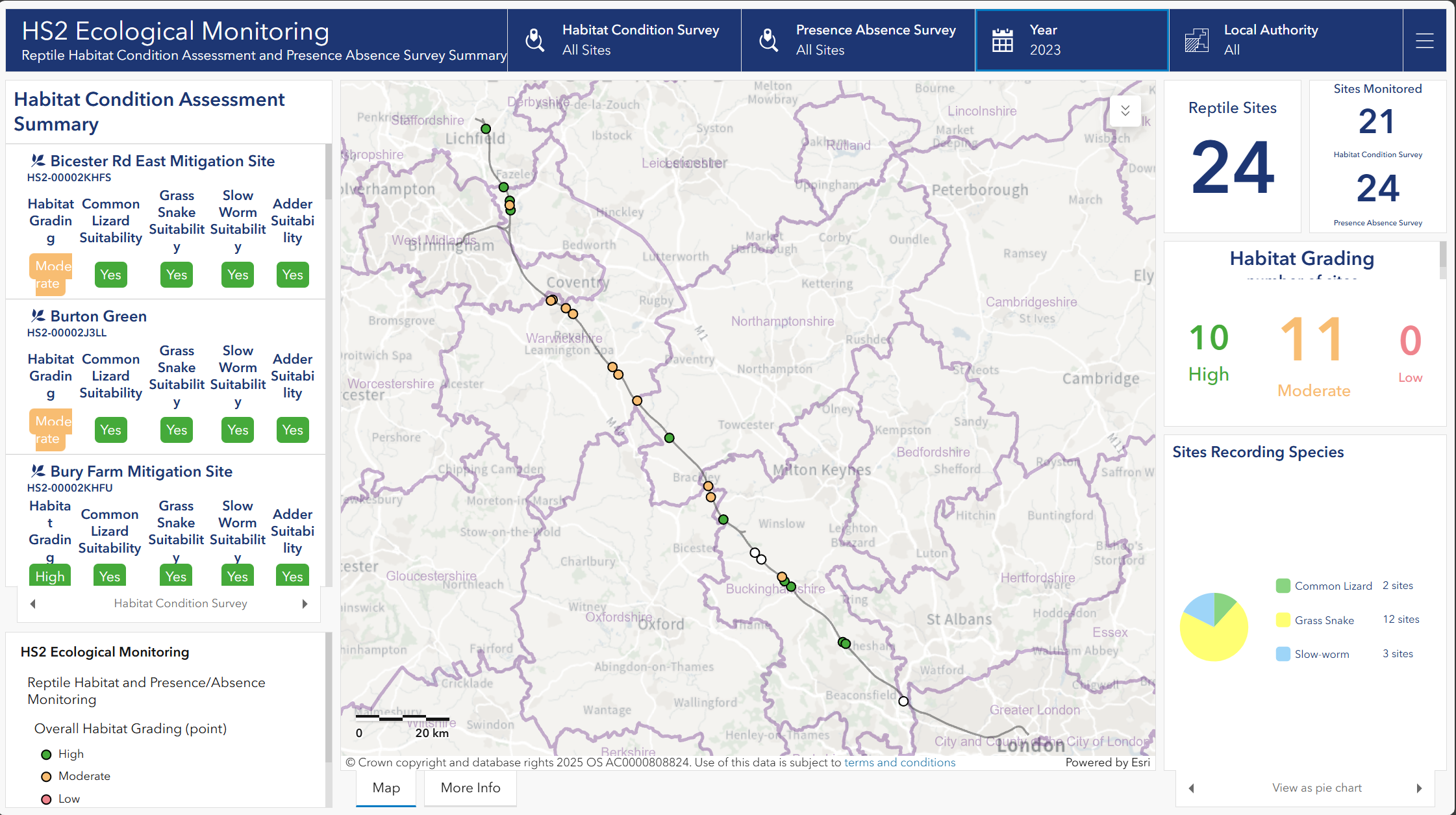
Note: Several of these sites remain within their initial establishment phase, having been created less than five years ago. Habitats typically do not achieve a ‘good’ condition score until they are fully established, so lower scores at this stage are expected and do not indicate failure. Instead, they reflect the natural time required for habitat development, which varies according to habitat type.
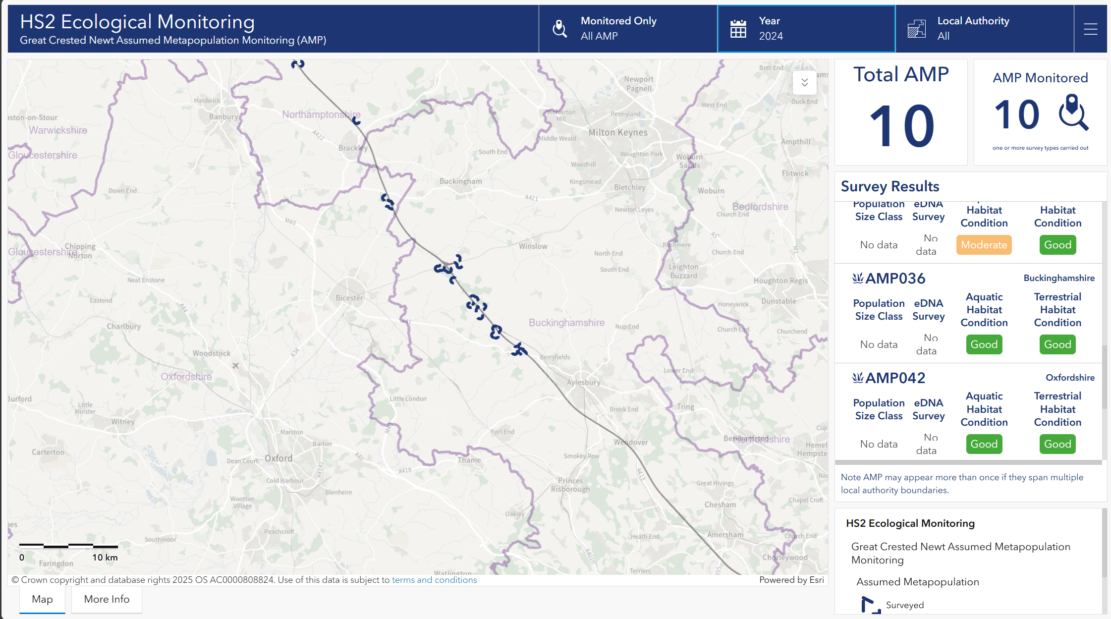
Note: Monitoring for GCN comprises a combination of eDNA surveys, aquatic habitat condition assessments, terrestrial habitat condition assessments, and population size class estimates. The specific methods applied at each site vary depending on the monitoring year, the extent of construction impacts, and other site-specific factors. Where data is not collected for a given method, this is recorded as ‘no data’.
This approach not only reflects the way data is collected, reducing manual conversions and risk of error, but also streamlines internal workflows. The HS2 ecology and biodiversity team can now query monitoring data quickly to support decision-making and respond to potential issues.
Developing the dashboards
Developing the dashboards required a structured and collaborative approach. The HS2 ecology and biodiversity team began by reviewing the objectives of the existing annual ecological reports to identify which data should be included and how it could be presented most effectively. Working closely with the GIS team, we explored what additional information was captured within survey schemas and could be integrated into the dashboards, either as map layers or supporting statistics.
Regular fortnightly meetings ensured progress was monitored, assumptions about scoring were clarified, and explanatory text was drafted to help users understand what each dashboard represents. Once initial versions were prepared, a review session was held with the ERG Chair and Natural England (NE). Their feedback was invaluable in refining the format, improving usability, and ensuring the dashboards were fit for purpose in supporting the ERG’s role.
Challenges
During development of the habitat condition reporting dashboard, it became clear that several underlying asset datasets required further refinement, which in turn limited the functionality that could be delivered at this stage. Work is now underway to update and strengthen these datasets, enabling more advanced dashboard features to be implemented as they are completed. A manual workaround was implemented, and a project is underway to strengthen the data formatting, enabling full automation and richer data integration in future.
Outcome and learning
The dashboards have been positively received by the ERG, Department for Transport (DfT), and NE as a user-friendly solution for managing complex ecological monitoring data. They set a benchmark for transparency and could be replicated by other large-scale infrastructure projects to support environmental commitments and best practice.
Engaging the ERG Chairman, and NE during the development of these dashboards was instrumental in ensuring they were fit for purpose and user-friendly for the intended audience. Their feedback led to several key improvements:
- Enhanced clarity and layout: Recommendations on the presentation of statistics and the interpretation of results prompted the addition of a ‘More Information’ tab on each dashboard, providing clear, accessible explanations to support reader comprehension.
- Improved usability: Suggestions to include mitigation site extents on each dashboard were implemented, offering greater context and transparency.
These collaborative reviews significantly strengthened the dashboards’ effectiveness and usability, ensuring they meet stakeholder needs and facilitate informed decision-making.
Following the sharing of the dashboards with the ERG members, additional feedback, particularly from the National Trust, highlighted opportunities for further enhancement. Key suggestions included:
- Consistent terminology: Ensuring uniform language across dashboards to improve clarity and strengthen the links between them.
- Standardised legend layouts: Repeating legend formats for consistency and ease of interpretation.
- Future development: Incorporating surveyor commentary to explain the rationale behind habitat scoring, linked to the data strengthening work discussed earlier in this micro-report.
These insights will guide ongoing improvements, ensuring the dashboards remain clear, coherent, and informative for all stakeholders.
Recommendations
- Plan for reporting early
Define what reporting will be required and how data will be used and how it will be presented or shared from the outset of a project. Missing this step can lead to poorly structured data, making later automation and reporting more complex and resource intensive.
- Engage key users throughout development
Involve those who will use the dashboards, such as ecology and biodiversity teams and third-party organisations, during design and testing. Regular meetings and user feedback sessions help ensure the dashboards meet practical needs and remain fit for purpose after launch.
- Set clear data standards from day one
Provide comprehensive guidance on survey schemas, asset tagging, and GIS feature requirements to contractors at project inception. This ensures data is captured accurately and in the correct format to support reporting, automation, and compliance.
Conclusion
The introduction of GIS-based dashboards marks a step change in ecological monitoring data management for HS2. By replacing static reports with interactive tools, HS2 has improved efficiency, transparency, and stakeholder engagement, while reducing resource burden and risk of error, and supporting the ERG’s remit.
Although further development is planned for the dashboards, they are now the standard method for communicating ecological monitoring data for ERG review. The dashboards have the potential to be adapted for other datasets, and this approach offers a replicable model for other large-scale projects seeking to meet biodiversity targets and demonstrate best practice.
Acknowledgements
The authors would like to thank everyone who contributed to the development of the dashboards, notably the HS2 GIS team and Matthew Robson, Amy Davies, and David Prŷs-Jones of the HS2 ecology and biodiversity team. Thanks must also be shared with:
- Colin Shawyer for helping to review and input into the barn owl ‘More Information’ tab text to clearly explain how each category is arrived at, as well as for undertaking the surveys.
- NE and the Chair for ERG; Geoff Bateman, Jonathan Pearce and Madeleine Ryan who provided early review and recommendations on the dashboards ahead of circulation.
- The ERG members for their feedback on the dashboards which will feed into future iterations.