Soils, Landscape and Woodland: How HS2 is using integrated asset information management in a BIM environment.
High Speed Two (HS2) is delivering a new environmental framework alongside the railway infrastructure; creating landscape plantings sites and new ecological habitats and features in advance of the main construction works. Before it comes into operation, Phase One of the HS2 Project intends to create around 650 hectares of new woodlands, to provide new habitats, screen communities and blend the new line into the landscape. This huge task is fully integrated with the construction programme, utilising integrated Asset Information Management to efficiently collect and manage information throughout the build and operation of HS2.
The use of Building Information Modelling (BIM) is particularly significant in the design integration to support delivery of landscape earthworks, ecology, tree and woodland surveys; pre and post construction implementation of diverse habitats, landscapes and future land management.
Using BIM to achieve HS2 aims is enabled through integrated design, which, in turn, improves supply and construction coordination, and informs management and maintenance of assets throughout the Project’s lifecycle. During Scheme Design, the efficient management of data within a Common Data Environment (CDE) has helped reduce potential impacts arising from construction by, for example, recording baseline information to minimise the loss of existing trees and hedgerows and validate the design decisions. Such benefits extend through the Detailed Design and Construction stages.
The quality of data capture and the use of a Common Data Environment to integrate datasets from across the environmental and engineering disciplines has improved early design decision making to influence land management. Cost efficiencies will be delivered by enabling HS2 Ltd to plan, construct and manage soils, landscape, and woodland assets throughout the lifetime of the project.
This baseline information enables efficient and stable transfer of design data between contractor’s design teams. The data has been used to work with stakeholders to develop the Green Corridor strategy and of habitats, access and recreational opportunities that is delivering benefits to communities along the route which link up with those delivered by the HS2 railway.
- Written by
-
Steve Fancourt (HS2 Ltd)

-
David Thompson (HS2 Ltd/HS2 Ltd)

-
David Whitehorne (HS2 Ltd/Jacobs Engineering Ltd)

- Resource type
- Resource type: Technical Paper
- Tags
- BIM posts
- CDE posts
- data capture posts
- digital posts
- ecology posts
- green corridor posts
- green infrastructure posts
- integrated design posts
- landscape posts
- soils posts
Introduction
By Spring 2021, High Speed Two (HS2) will have already planted over 700,000 new trees, the important first steps to achieving 7 million new trees along the first phase of the project. Over the next decade, the project will create around 650 hectares of new woodland, designed to provide new habitats, screen communities and blend the new line into the landscape.
Future opportunities, for what is known as the Green Corridor [1], are being developed with stakeholders to support HM Government’s 25 Year Environment Plan. Recent ‘Green Recovery’ opportunities through enhanced funding for active travel through a joined-up system of improved cycleways and footpaths will contribute to meeting health and well-being goals and clean air targets of benefit to communities along the route. This is particularly key for those communities that are affected during the construction period.
Through an integrated and collaborative approach, the design, construction and operation of HS2 provides opportunities for the development and implementation of innovative processes and methods. The use of Building Information Modelling (BIM) is particularly significant in the design integration to support delivery of landscape earthworks, ecology, tree and woodland surveys; pre and post construction implementation of diverse habitats, landscapes and future land management.
Building Information Modelling
Traditional risks in complex multi-facetted infrastructure programmes are recognised as factors leading to poor performance across the industry. These include information loss across the multitude of contract packages, poor interface management, misalignment of programmes or costly construction error. The BIM process ensures the coordination, verification and validation of information at every stage of the project lifecycle. The massive scale and complexity of HS2 means that a large volume of complex data sets must be managed, exchanged and interpreted by a range of engineers, architects and environmentalists. HS2’s BIM Team is leading and defining the definition of assets which is being used to improve the design, management and maintenance of all its assets. These are being populated by the Design Teams to deliver data on soils, habitats, drainage catchment, and noise impacts which the environmental designers draw on to define high performing landscapes that are invested to deliver public goods and benefits throughout the project life cycle.
BIM comprises of two key components: information management and information modelling. Information management is about how project and asset information is structured, ensuring it is communicated contractually to get consistency in the ways in which data is produced and delivered; it provides a consistent collaborative process to information management. Information modelling is the exploitation of digital data to support data analysis, visualisation and reporting. Both the process and technology go hand in hand. However, BIM is also reliant on people’s behaviours and their ability to work in a collaborative environment. It is people, following agreed processes and using the appropriate tools and systems, that will result in greater assurance, governance, provenance and mobility of data and information.
By mandating the BIM process, different information sets are collected and managed within the contractor’s 3D models. These are overlain with environmental survey data to provide a comprehensive view of the various design components. These are managed as a digital data set in a Common Data Environment (CDE). The CDE is configured to a set of consistent and standard processes which enable efficient and accurate exchange and integration of information across multi-disciplinary teams and with the HS2 Client. This use of digital tools to manage complex information and data across the entire life cycle of a project represents an important shift from documents to data driven information sharing. HS2 Ltd is harnessing the power of digital engineering, with BIM at its foundation, to develop a Virtual Railway Twin in which to plan, test, verify and validate design and construction. The embedded value is to ‘design once and build wisely’. Integrated data driven management and maintenance processes is making significant cost and programme efficiencies.
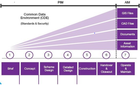
The data set starts with the managed collection of consistent and reliable information, referred to as the Project Information Model (PIM). For soils, landscapes and woodlands this comprises a series of desk top studies and field surveys using data-specific proforma to record the information. The collected information is transferred to platforms such as gViewer, HS2 Ltd’s GIS system, which forms part of the CDE. All asset related information is connected to the Asset Information Management System (AIMS), also part of the CDE. This is the core database of information and provides the means by which data can be managed and shared. The overview of this process is illustrated in Figure 1. Currently most of the assets designed by the Main Works Contractors are reaching the completion of Scheme Design (Stage 3) with some well advanced onto Detailed Design (Stage 4) and a few delivering site Construction (Stage 5). The volume and maturity of information is rapidly growing, and this exponential data maturity is leading towards such time that the project is ready for handover to operations and maintenance as a complete, validated and verified Asset Information Model (AIM).
Soils, Landscape and Woodland
The ability to manage assets such as landscape features, woodland and soils requires the availability of reliable and accurate information. The length of the HS2 route and the consequent variety of landscapes requires a robust system of data capture to ensure that data is both reliable and in a format that is compatible with the BIM platforms, including CAD, gViewer and AIMS. The quality of data collection therefore is critical, and this in turn is dependent on the capabilities of the people collecting, collating and transmitting data. For Phase One of HS2, the Contractors and their supply chains confirm a process of self-assurance that data is of a reliably high standard. This is defined by compliance with a series of Technical Standards that prescribe the methods for data collection and recording, coupled with the use of bespoke recording proforma developed by HS2 Ltd. One example is the Trees and Woodlands Stage 1 and 2 survey standards which capture the baseline data for woody vegetation across the Project. These Requirements, based on existing industry standards, enable efficient capture of data. For trees and woodlands this is fed into the design process to identify which trees and woodlands can be retained because they are outside the construction footprint, those which must be removed to allow the railway to be built and those areas where redesign should be assessed to see if retention is possible. This ensures seamless integration of data within the Contractor’s supply chain and on to the future vegetation management operations, by HS2, landowners or stakeholders thus maintaining an efficient flow of data quality during transfer of responsibility for land management.
Soils
The sustainable reuse of displaced soils is recognised by HS2 Ltd as a key environmental mitigation measure. Conserved soils are being used for the restoration of land to agriculture, landscape earthworks, forestry, landscape planting and habitat creation. For agricultural restoration the primary objectives are to reinstate land to its original Agricultural Land Classification (ALC) grade (MAFF, 1988) [5], and to restore the full soil resource in the correct sequence of horizons.
Information on soils along the route of Phase One has been collected through a combination of desk top studies of existing soils information, and soil surveys. The soil survey data is recorded in a bespoke soil recording proforma for each Land Registry parcel surveyed and each soil sampling location is geo-referenced. The output of this work comprises a master database of soil observations, uploaded to the GIS mapping, which correlates the location of observations, the relevant physical and chemical characteristics, and the ALC grade, all in a CDE on gViewer. The information is fed into the construction process to facilitate mapping the origin and destination; their structure and storage, so they are managed to reduce multiple handling and retain condition for reuse of soils.
This information enables the delineation, quantification and characterisation of the topsoils and subsoils available within the construction area prior to these materials being stripped. It records the sources, locations, contents and approximate volumes of soil stockpiles. The information allows assessment of the suitability of the different soil materials for reuse, including reinstating agricultural land temporarily affected by construction. It is informing the soil handling necessary for the successful translocation of Ancient Woodland Soils and preparation of landscape planting areas and habitats on new landforms.
Landscape Character
Landscape character assessment was an integral part of the technical studies submitted to Parliament in support of the HS2 Project and the hybrid Bill.
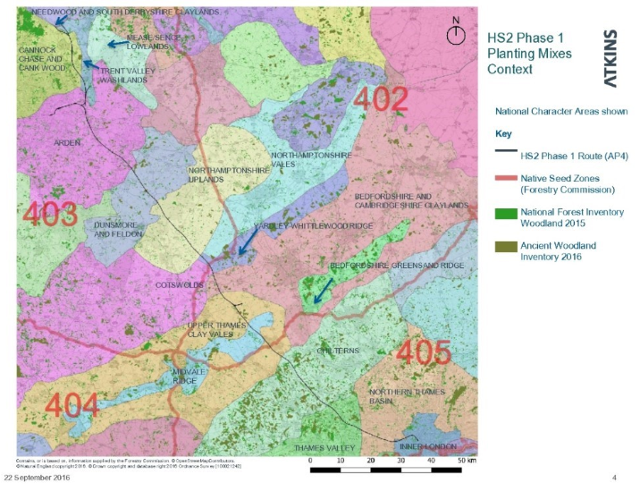
This assessment identified fourteen of Natural England’s National Character Areas (NCA). Using these NCA’s, HS2 overlain data from the National Forestry and Ancient Woodland inventories, along with Forestry Commission seed zones, to inform the selection of native tree and hedgerow planting mixes. This in turn drove the specification for native tree species that have been grown under the HS2 Tree Supply Contract and supplied to Contractors along the route. Figure 2 shows the Phase One HS2 route overlain on the National Character Areas map. This information provides the framework for delivering the landscape vision. The Contractor’s planting strategies reflect the necessary contextual palette of woodland types, hedgerows and wildlife habitats. By combining the extensive database held in the CDE native plant species and mixes have been selected to deliver locally responsive to the varied geology, soils, seed zones and landscape character within the HS2 rail corridor. The planting of up to seven million trees, will assist integration of the railway into the pattern of the English landscape. Enabling connectivity of existing and new woodlands, will diversify and extend habitats and provide visual screening. This will help Government deliver on the “bigger, better, more joined up” challenge posed by the Lawton Review in 2010 [2] to how England’s wildlife and ecological network could be improved to help nature thrive in the face of climate change and other pressures. A coherent and resilient ecological network will help wildlife cope with change but will also improve the wider benefits the natural environment provides for the nation’s health and well-being. Decisions on planting species and target locations are informed by site surveys and held in AIMS. Such information is being fed into the development of HS2 Ltd’s maintenance of landscaped areas[3]. In respect of Ancient Woodland compensation measures these commitments are mandated for 50 years so the CDE is critical to ensure a secure flow of data to inform management and monitoring operations as part of HS2’s commitments.
The Phase One contractors and their design teams are using this layering of information to test the design to minimise adverse landscape and visual effects during construction. One successful example has been to avoid or reduce the loss of Ancient Woodlands predicted under the Phase One Environmental Statement [4]
Woodland
A significant database of information has been collated on woodlands and proposed woodland creation sites within and adjacent to the HS2 Phase One route. Desktop studies and comprehensive surveys have determined existing woodland information, site designations, ancient woodland inventory status, woodland composition, structure, vegetation classification, soils, hydrology and associated protected or notable species. The presence of invasive non-native species (such as Japanese knotweed) is also recorded.
Pre-construction surveys of trees and woodlands, commissioned from 2017 onwards, provide an accurate picture of the resource. This information forms a key framework to developing the soils and earthworks design. This, in turn, influences the extent of trees, hedgerows and woodlands to be retained during the building of the railway. The data from survey results are captured in the CDE by a set of HS2 standard reporting proformas to ensure a consistent approach is applied across the route. The information provides the baseline to inform design and construction decisions alongside end state management.
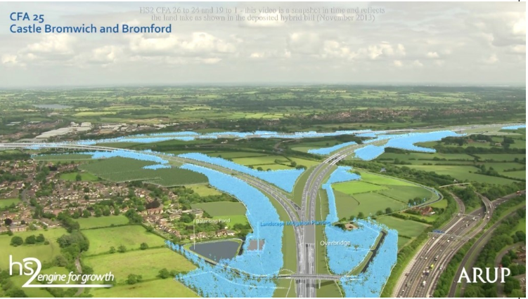
HS2 Ltd has committed to planting extensive areas of woodland for landscape mitigation and ecological habitat creation. This planting reflects and complements local woodland characteristics and species. Consultation with the Forestry Commission has informed the final species selection and the range of local provenance, with the aim of resilience to future climate change. An illustration of the reach of landscape works is shown in Figure 3. This visual, from an HS2 Ltd flythrough, indicates in blue proposed woodland planting to recreate and enhance local landscape character and provide a new ecological framework. This is providing the ’Bigger, Better, More joined up’ landscape to mitigate adverse landscape and visual effects identified in the HS2 Environmental Statement [4].
The Application of BIM
An example of the way that data will be combined and used in AIMS is the soil surveys. This data provides a new approach to pre-construction audit of soils; their management and recording of soil stripping and storage, leading to the effective restoration of a scarce soil resource back to agricultural land taken temporarily during construction. It has also been developed to enable the identification of suitable soils for landscape construction and restoration, and to define soil profiles for target habitats. This information is being used to define management operations to be undertaken by the landowner or future management body. The CDE feeds into BIM processes to ensure information is continuously built on; is stored and is accessible by all users. BIM processes, informed by the CDE, is the structure for integration of design and enables the project to be tested digitally before it moves on to site. This has major cost and programme benefits to minimising lost data and waste of resources in reworking designs or costly changes during the build phase.
Conclusion
The implementation of the CDE, asset management systems and BIM processes has enabled improved design coordination, management and maintenance of assets throughout the project lifecycle. During scheme design, efficient management of data within a Common Data Environment has minimised adverse construction impacts by minimising the loss of trees and hedgerows. Such benefits extend throughout the design and construction stages where data is readily shared with stakeholders to facilitate complementary integration, planning, design and management of river catchments and green corridors that lie outside HS2’s powers to act. The quality of data capture in the Common Data Environment has integrated datasets from across the environmental and engineering disciplines and improved early designs. In turn, permanent designs have been enhanced that, in turn are influential in future land handback and management decision making. Thus, HS2 Ltd enables its supply chain to plan, construct and manage soils, landscape, and woodland assets throughout the project’s lifecycles.
HS2 Ltd is harnessing the power of digital engineering in the Common Design Environment Digital Engineering, with BIM at its foundation. The development of the Virtual Railway has enabled planning, testing, verification and validation of integrated design and construction. One example relevant to Soils, Woodland, Landscape is the monitoring of the collection and translocation of ancient woodland soils onto the receptor sites. This sensitive process is being recorded by contractors in GIS to track the origin and destination of soil types and depths into each receptor site. This information will be used during the aftercare and monitoring of sites to assess the success of their development. This is valuable data both during the critical establishment phase as well as the commitment for long term management for the next 50 years. During construction, sensor enabled devices feed real-time data back into the digital model. This live connectivity between the Virtual Railway and the physical assets forms the basis of Digital Twin and enables close to real-time monitoring and performance management over the 120-year design life of HS2.
References
[1] “More than a Railway. HS2 and the natural environment” (2018)
[2] “Making space for nature” The Lawton review (2010)
[3] HS2 Phase One information papers: environment (series E16: Maintenance of landscape Areas 2017)
[4] Department for Transport and High Speed Two (HS2) Limited (2013) (1): HS2 Phase One environmental statement volume 5: agriculture, forestry and soils.
Department for Transport and High Speed Two (HS2) Limited (2013) (2): HS2 Phase One environmental statement volume 5: ecology
Department for Transport and High Speed Two (HS2) Limited (2013) (3): HS2 Phase One environmental statement volume 5: landscape and visual assessment
[5] MAFF (1988): Agricultural Land Classification of England and Wales. Revised guidelines and criteria for grading the quality of agricultural land