Geospatial Information Systems (GIS)
A framework for gathering, managing, and analysing data, rooted in the science of geography. GIS analyses spatial location and organises layers of information into visualisations using maps and 3D scenes to reveal deeper insights into data.
Geospatial Information Systems (GIS) Resources
Resources include papers, videos, research summaries and good practice documents produced by authors from across the HS2 Family to capture learning, good practice and innovation from the HS2 programme
-
Published on
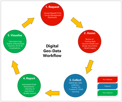
Construction stage geo-data collection, reporting and visualisation – digital workflow
This paper presents an innovative digital workflow designed to address the challenges associated with collecting, reporting, and visualising construction stage geological and geotechnical ground data (geo-data). It emphasises the importance of this data in informed decision-making, to achieve efficiencies, optimisation, and, most importantly, risk assessment and mitigation. The limitations of traditional geological mapping workflows and…
-
Published on
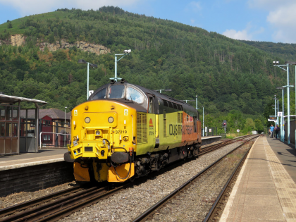
Using Train-Borne Lidar to improve design confidence in railway electrification
The Midland Main Line needs to be remodelled and electrified to accommodate High Speed Two (HS2) train services to Sheffield. This paper addresses how the issue of site surveys, to accurately judge the level of intervention required for the system design, without site access, was solved. Detailed measurements were required on the 26km route, which…
-
Published on
Digital mapping of environmental significant effects on HS2 Phase 2a
Protected species constraints are an early consideration for nearly every development project, and where impacts cannot be avoided mitigation licensing is a legal requirement. HS2 Ltd are the licensee for a great crested newt organisational licence, as part of the Phase One works; the largest such licence ever issued by the regulator for a single…